RealImaginarySmokies Day 2 – Cumberland Gap & Camping in Great Smoky Mountains National Park

We continued south on US-23 into Virginia and cut west on Alt-58 and US-58 to Cumberland Gap National Historic Park, where Virginia, Kentucky, and Tennessee all meet. After enjoying the view there at Pinnacle Overlook, we stocked up on groceries in Knoxville and drove through Townsend into Great Smoky Mountains National Park, where we set up at Elkmont Campground.

In Search of Breakfast

We spent our first night on the road in a warm cozy room at the Eastern Heights Motel in Ivel, Kentucky. We were up bright and early at 6:30am and got on the road just before first light at 7:15am. An early high fog hung just over the hills, shrouding the tops in mystery. About a half an hour after we got going, the sun quickly burned it all off.

We decided to start our day by looking for breakfast. I preferred finding a mom & pop greasy spoon over a national chain place. I expected that there would be plenty of these along US-23, but I was hard-pressed to find any using Google Maps the night before…maybe they never got on the map? So we kept driving south along the highway, keeping our eyes open for prospects.

As we came up to Pikeville, about 10-15 miles from our motel, we decided to exit and search there in hopes of finding something. What I didn’t know is that Pikeville is a more sizeable college town. While there were large sports facilities, parking decks, and big-brand hotels, there was not much in the way of restaurants—especially for breakfast. On the main drag that appeared to be where the US highway used to snake through, we did find Roasted, Coffee and Cafe. However, I didn’t see any breakfast choices that appealed to me for the $5 price tag. So Becky bought her usual espresso and we continued south.

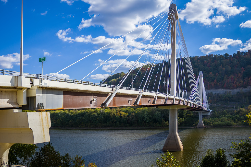
Eventually, we began ascending further and further up hills in the mountains until we went over Pound Gap and crossed into Virginia. Mom & pop dining options along the way were sparse, and we often missed them until we were about to pass them at nearly freeway speed…so it was after 9am and I was still quite hungry. Finally, near the town of Wise, we passed through a commercial strip area where I settled for Huddle House. While the food wasn’t super spectacular or super cheap, it did hit the spot so we could continue on our way.

Morning fog lingers over a valley to the south of Pound Gap.

It wasn’t far to the south where we finally diverged from US-23 at Big Stone Gap and started following Alternate US-58, which is known as Trail of the Lonesome Pine Road most of the way. We passed through several quaint little old valley towns with some beautiful brick buildings right up against the street. In Jonesville, the alternate leg of US-58 joins the mainline highway again and we began following the Wilderness Road. After we meandered our way through countryside and a few more hamlets, we arrived at Cumberland Gap National Historic Park.

Cumberland Gap National Historic Park

Now the Wilderness Road was one of only two good routes across the Appalachian Mountains into Kentucky (the other was the Cumberland Road, which later became part of the National Road that went across from Cumberland, Maryland). Daniel Boone was the man hired in 1775 to blaze a trail that opened up settlement in Kentucky, and that trail became known as the Wilderness Road. It crossed the mountains at Cumberland Gap, which is now the site of a national historic park run by the National Park Service.

Cumberland Gap had been used by Native Americans to cross the Appalachians long before the colonial era. After Daniel Boone carved his trail, it was later widened to allow wagon traffic to pass. It held a great deal of strategic significance during the Civil War, changing hands multiple times. When the US Highway System was created in the 1920s, Cumberland Gap carried US-25E. The Wilderness Road across Cumberland Gap was restored to its historic appearance as a wagon trail in 1996, when US-25E was rerouted through the new Cumberland Gap Tunnel.

Cumberland Gap Tunnel

Inside the Cumberland Gap National Historic Park Visitor Center

Fern Lake between the trees at Pinnacle Overlook

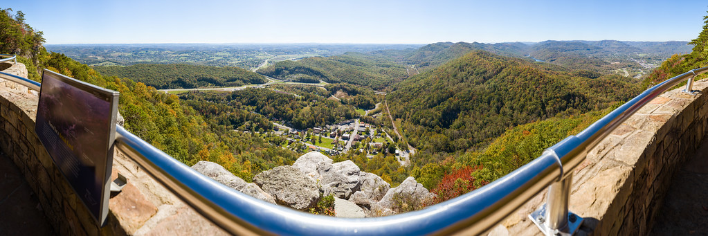
When we arrived, we passed back into Kentucky through this tunnel, and exited the highway to go to the Cumberland Gap National Historic Park Visitor Center. Besides taking a quick look around, I asked a ranger about which parts of the park were the best. It was already about noon, and we still had at least 2-3 hours to drive and a stop for groceries before we made it to Great Smoky Mountains National Park…so we didn’t have more than maybe an hour or two here if we were going to beat rush hour traffic out of Knoxville. The ranger said that hiking across Cumberland Gap doesn’t offer much to see besides the trail itself—but she definitely recommended that we drive up the mountain to Pinnacle Overlook.

So we set out on the winding switchback road up the mountain to a parking lot with ample space. Several short trails, including one that is handicapped-accessible, took us just over the Virginia state line to Pinnacle Overlook. The view here did not disappoint! You can see for several miles across a few towns, countryside, and forested hills to the south, including Tri-State Peak, where the borders of Virginia, Kentucky, and Tennessee all come to point, and tranquil Fern Lake. I spent a good hour photographing from the vantage point here, since it was a relatively clear day and lighting conditions were rather favorable.

Hey, a stranger we met snapped a decent picture of us!

Becky with one foot in each state on the trail back to the parking lot

Overlooking Tennessee and Kentucky from Pinnacle Overlook in Virginia…I will post a link to the full-res version (1.2 gigapixels!) when I get it uploaded…

Continue reading RealImaginarySmokies Day 2 – Cumberland Gap & Camping in Great Smoky Mountains National Park

RealImaginarySmokies Day 1 – The Scioto Valley & Eastern Kentucky

We followed Riverside Drive along the Scioto River into Downtown Columbus, where we headed south on US-23. We then took US-23 through Chillicothe and followed scenic SR-104 out of Waverly and into Portsmouth. After dinner in Portsmouth, we took US-52 along the Ohio River, crossing into Eastern Kentucky at Ashland to follow US-23 south to the Eastern Heights Motel in Ivel.

Starting Off Around Columbus

So there’s a twist for our last road trip this year! Rather than starting out from home, we start out today from Delaware, Ohio, where our friends Justin and Jennifer live. Jennifer organized a Star Wars-themed costume party in nearby Columbus last night. Besides not wanting to miss hanging out with one of her best friends, Becky is an avid cosplayer and a rabid Star Wars fan. Some fans wear costumes to celebrate their favorite sports franchise, while Becky loves getting everyone in costume to celebrate her favorite movie franchise. I always liked Star Wars too…and will say that it is more fun this way!


Anyway, we spent the night at Justin and Jennifer’s house last night, putting us about an hour or so closer to our destination for the night, which will be some as yet undetermined motel. Rather than taking freeways, we’ll mostly take US-23 the entire way, which will take us through parts of Ohio and Kentucky that neither of us has ever seen. I’m not sure where exactly we’ll stop, because I honestly have no idea how long we’ll spend at stops along the way. And we’re getting a motel because tonight will be the first freeze of the season in much of the Midwest and Appalachia. The weather warms up over the course of the week, and should be just fine for camping.

Following the Scioto River

We started out by following US-42 to SR-257/Riverside Drive, which eventually becomes US-33 and Dublin Road. Along the way we passed two dams and the Columbus Zoo. The drive was very pleasant, with a park between the road and the river almost all the way down. It reminded me of the Valley Parkway in the Cleveland Metroparks or Riverview Road in the Cuyahoga Valley National Park, except much busier and with a lot more development.

The plan was to take Dublin Road until it becomes Long Street downtown, where we’d turn south on High Street towards the south side of Columbus. Unbeknownst to us, the Columbus Marathon was being held today, so it was impossible to get to High Street north of I-70. We lost some time trying to figure this out, but we eventually got back on track.

Now US-23 follows High Street at this point, and runs all the way down along the Scioto River from Downtown Columbus to Downtown Portsmouth, which is where the highway crosses the Ohio River into Kentucky. Along the way you pass through or around the towns of Circleville, Chillicothe, and Waverly, which along with Cleveland and Akron were on the route of the old Ohio & Erie Canal. The Ohio & Erie Canal revolutionized travel and shipping across the state in 1832, reducing the trip from Cleveland to Cincinnati from a few weeks to just 80 hours. Railroads came along two decades later, causing most of the canal to become abandoned early in the 20th Century.

There are three things I’m especially interested in seeing along our route this afternoon: the Scioto River for one, the city of Portsmouth since it’s on the Ohio River, and the city of Chillicothe, as it was Ohio’s original state capital. Had it not been for so much politicking in the state’s early history, perhaps Ohio’s “Three C’s” would have been Cleveland, Cincinnati, and Chillicothe! I suppose we’ll never know, but maybe that’s how things unfolded in a parallel universe…so maybe one day we will find out…

Chillicothe

Since US-23 now bypasses Chillicothe, we exited to follow Business-23 (which quite honestly is the only Business Route I’ve ever seen in all of Ohio) to go through town. The actually center of Chillicothe is a few blocks off of the old US highway, so we took a detour to check it out. While there were lots of old buildings in good repair, Chillicothe didn’t seem to be all that big of a place and was certainly not bustling this Sunday afternoon.

So we continued south back to the bypass and continued to Waverly. On the south side of Waverly, we followed SR-104, which follows the Scioto’s west bank all the way to Portsmouth. This road was marked scenic on my Rand McNally atlas, and it did not disappoint. There were sweeping views of the river all along, passing through small farms and unincorporated hamlets. The land along this part of the river seems vastly untouched.

Portsmouth, Ohio

The Ulysses S. Grant Bridge connects Portsmouth, Ohio across the Ohio River to Kentucky.

The road joins up with SR-73 just before West Portsmouth, and at the interchange with US-52 we stayed on SR-73/104 to go through Portsmouth. At this point, you can see two prominent bridges…a steel cantilever bridge directly ahead, and a newer cable-stayed bridge towering to the east. After we crossed the Scioto River right next to its mouth, we noticed a huge floodwall a block away. Besides its height, the 21-foot floodwall attracted our attention because it was covered in murals across the entire western section of the city.

It was definitely time for us to refuel, and the cheapest gas I found was just over the river in Kentucky. So before we got dinner and explored some more, we drove across the cable-stayed bridge on US-23. After gassing up, we went back over to Portsmouth to a restaurant I’d found on Google Maps that had a menu that worked for both of us.

Continue reading RealImaginarySmokies Day 1 – The Scioto Valley & Eastern Kentucky