Seven Hours, No Stops!
We made it…this far! Once we got out of Greater Cleveland, traffic was a breeze, even around Chicago. Incredibly, Becky made the entire 7-hour drive without even a single stop! This got us to our hotel in the Quad Cities last night at 11:30pm local time. Checkin at the LaQuinta Inn Moline Airport was a breeze, and we settled into bed maybe a minute or two past midnight.
Iowa
‘Tis the Season
I haven’t had the best time sleeping lately…it seems 4 or 5 hours is about all I get most nights. I set an alarm for 6:15 with the hopes we could grab a quick breakfast in the hotel lobby and get on the road. My sinuses had other ideas—every year they let me know when August arrives. This morning they reminded me, which made it difficult to exist let alone get up. Becky was feeling it too.
“The World’s Largest Truckstop”
We finally got out the door and back on the road at 7:30am. The Iowa 80 Truck Stop just west of Davenport was our first refueling stop of the trip. It bills itself as “The World’s Largest Truckstop”, with about half a dozen fast food franchises, a ton of retail, a buffet restaurant, plenty of American automotive memorabilia, and of course gas and diesel.
Where We’re Going, We Don’t Need Interstates…
Normally we just follow I-80 all the way across Iowa. This time I wanted to try a different route farther north. US-20 runs from coast to coast—Massachusetts to Oregon—and it passes maybe 50 miles north of I-80 through Central Iowa before running across Nebraska within a few miles of the South Dakota border. Today we’ll head up I-380 to join US-20 until Sioux City, where we’ll diverge on the Outlaw Trail Scenic Byway to follow the Missouri River more closely.
The Great Plains: #NotFlat #NotBoring
I can’t say this enough, but I don’t understand why people repeat over and over again that the Great Plains are flat. I mean, I realize it’s not exactly mountainous (except it actually is in the High Plains!), but most of it has rolling hills. Eastern Iowa is especially pretty where farmers sow their crops to follow the terrain. We usually go through in July. August offers larger and more mature plants, including tasseled corn, but everything is still a wonderful green. When we passed through last September, things definitely appeared less verdant.
Splat 🙁
The weather was mostly cloudy at first. We even hit some rain between Cedar Falls and Fort Dodge. We also hit some gigantic bugs with yellow innards. Yuck. (Turns out these were actually monarch butterflies! Now I feel guilty too! Those poor things have it tough enough!)
Driving Across Iowa on US-20
We found the drive across Iowa on US-20 very pleasant compared to I-80. Traffic is nearly nonexistent past Fort Dodge, and the route is more scenic in the Western part of the state. The only drawback we discovered was the total lack of rest areas…but there were adequate numbers of gas stations all the way up to Sioux City.
Nebraska
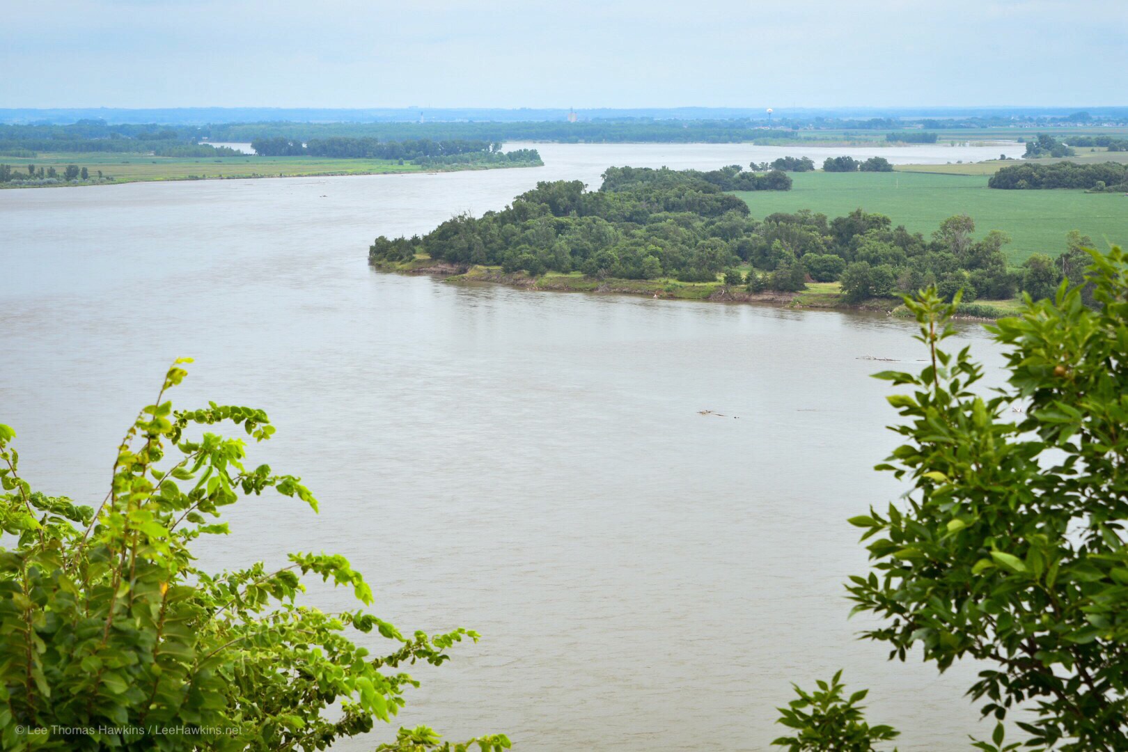
At Sioux City we crossed the Missouri River and the state line into Nebraska. After stopping for fuel we diverged from US-20 to begin our journey along Highway 12—the Outlaw Highway—which follows the Missouri River and the state line with South Dakota.
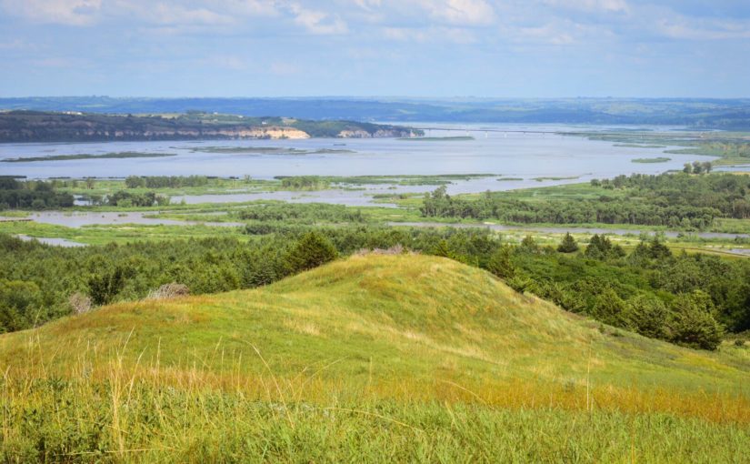
Ponca State Park
Our first stop, Ponca State Park, preserves a section of the River that still looks much the way it did back in the time of Lewis & Clark. We stopped to enjoy the view at the Three State Overlook, where you can see South Dakota and Iowa while standing in Nebraska. This is one of the few places where the Missouri River hasn’t been dammed, straightened, or bypassed with a canal to better facilitate shipping (and flooding). The overcast sky and humidity weren’t the most comfortable, but it was exciting to ponder the beginning of Lewis & Clark’s adventure across the continent, as well as their return through this stretch of river two years later.
Rolling Hills, Bridges, and Bluffs
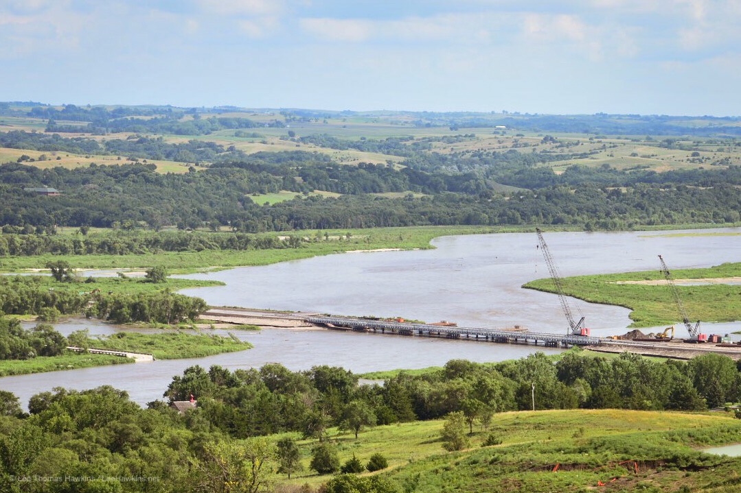
Highway 12 from Ponca State Park to our next stop, Niobrara State Park, meanders through a driftless region of huge hills and bluffs unscultped by glaciers. A few miles before reaching our destination, the highway descends to a few feet above river level just before the town of Niobrara. This has been an extraordinarily wet year, and floodwaters still reach the road on both sides.
Back in March, the Spencer Dam broke many miles upstream on the Niobrara River. This washed out several bridges throughout the area, including the bridges on Highway 12. There’s some spectacular footage of one of the bridges floating downstream online! A temporary replacement bridge opened only last night, making it possible for us to visit Niobrara State Park just on the other side, rather than having to take a huge detour through South Dakota.
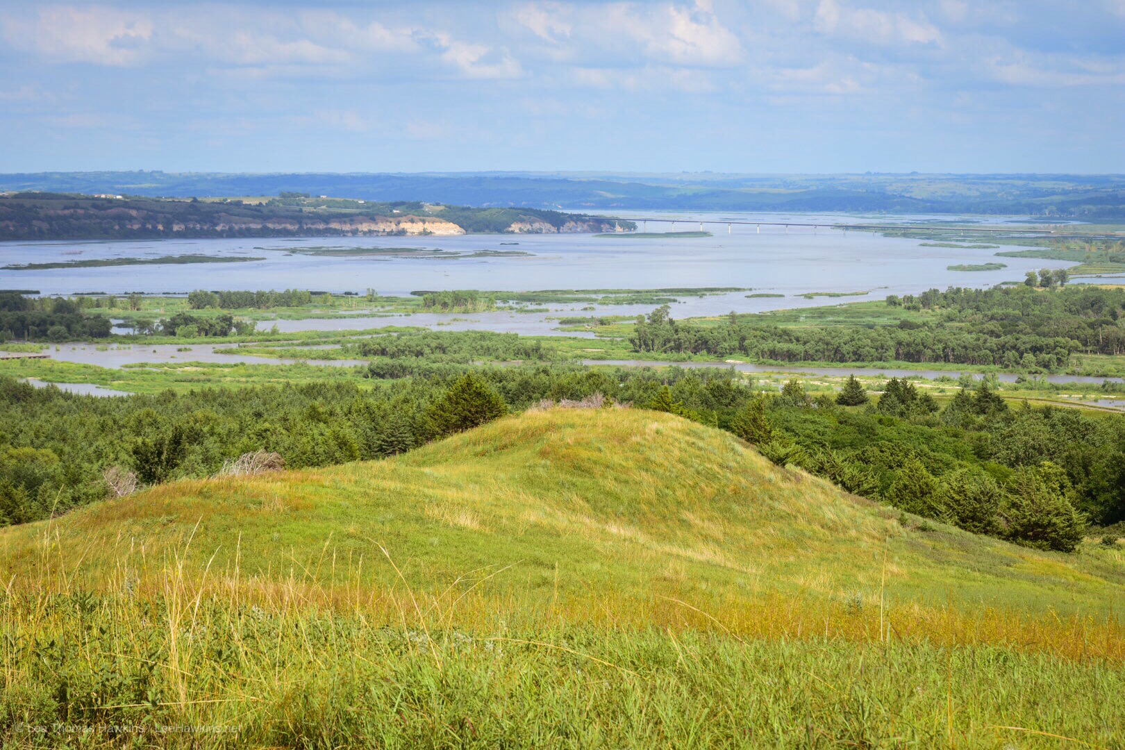
Niobrara State Park
Niobrara State Park is much larger than Ponca, and offers even more expansive views of the Missouri River and the Niobrara Valley. The terrain is still remarkably rugged and beautiful in this area. We stopped for a small picnic and took the three-mile scenic drive before getting back on the road.
Remote Northern Nebraska
Our final stop of the day, Smith Falls State Park, lies about 2 1/2 hours away near the end of Highway 12. I think I could count on one hand the number of cars and gas stations we passed! There might have been 3 small towns with 2-300 people in them along the way. We stopped at the Turbine Mart in Springview, the last gas station and potentially our last chance to buy ice before arriving at Smith Falls.
I spent a few minutes talking to the attendant inside about where I was from and how remote this area is. She asked me if it scared me to have so few people around. I said, “Sure it does, but it also excites me to see how open and beautiful it all is too.” I really enjoy seeing parts of the country like this, but I still prefer living in or very near a major city. She told me a lot of tourists passing through are afraid of being so alone in this vast area of hills and farms—she said that she feels uncomfortable in a city with so many people everywhere.
Smith Falls State Park
We arrived at Smith Falls State Park right around 7:30pm Central Time. About a mile off of Highway 12, the road turns to gravel and dirt for the last 3 1/2 miles, but it’s well-maintained. We pulled in first to the camp office which was closed, but there was an envelope taped to the window with our name on it! I totally forget most of the conversation, but I called back in May or February or something asking for a reservation, so I guess that paid off!
Now to get camp set up so we can go see the waterfall! Unfortunately, the road through the campground has really been beat up by all the rains. It took us quite a long time to assess the situation. Were it not for some help from our site neighbors, Jared and Ki, we would not have figured out how to get our car to our site without hitting bottom on a pothole or getting stuck in the mud.
Smith Falls
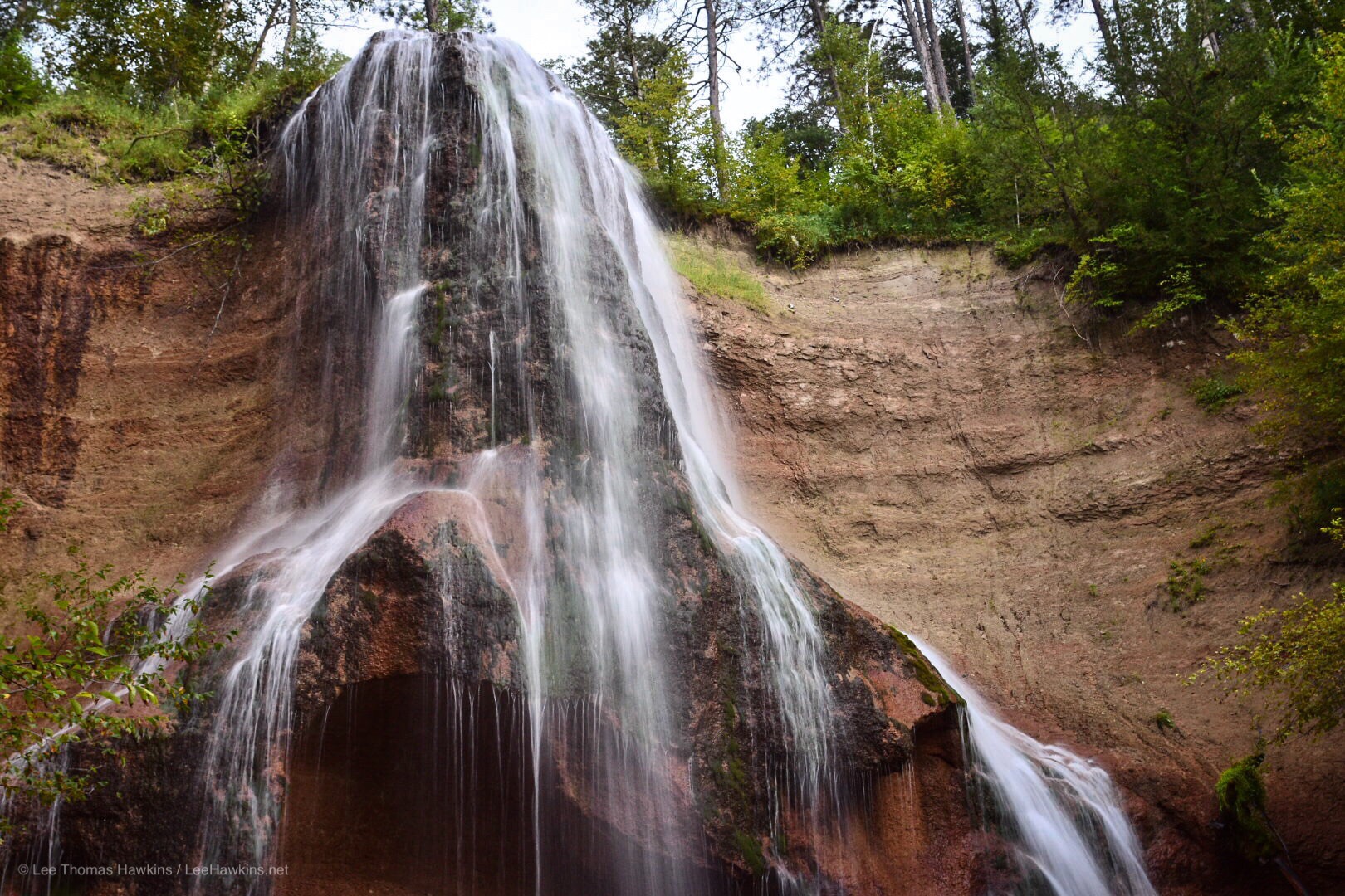
The good news is that our site is directly next to the whispering waters of the Niobrara River. After we got our tent and bedding set up, we rushed on to see 76-foot Smith Falls, about a half-mile or so walk from our site. We followed the trail across the Verdigre Bridge and up the boardwalk to Nebraska’s tallest waterfall. On our way back, the setting sun gave us a brilliant light show over the river as we crossed the bridge back to the campground.
At this point, Becky and I set to getting some real food. We’d eaten mostly potato chips, trail mix, fruit, little mini sausages, and hard boiled eggs since we left last night, so real food sounded delightful! Our generous neighbors had left a few pieces of firewood for us, so I just had to offer to share some of my Great Lakes Holy Moses Raspberry White Ale with them, since they said they enjoy craft beer.
Turning In For the Night
Before I even really got started on dinner, I lost Becky. She was nowhere to be found, so I asked if she was in the tent as I passed…she answered that she was, and that she couldn’t do it anymore. We have been going all day today and all day yesterday, and most of the week too to get ready—so she was exhausted.
So I decided to try and get a fire going and maybe roast up a couple of hot dogs for myself. The bugs and the humidity did not make this easy, but the cold beer helped. I turned in at about 10:30.
Tomorrow, Wyoming!
Tomorrow we’d need to get an early start so we could see the Bridges-to-Buttes Scenic Byway and head into Wyoming for the night. For now, I’ll fall asleep to the whispering waters of the Niobrara River…