We both woke up for our own reasons around 5am this morning. (You can probably guess what they were.) My pad was deflated again, so I did something about that when Becky got up. Sadly for me, I was too warm in the cold, and sweat so much that I think it saved me an earlier trip to the restroom. Sadly for Becky, she did not stay comfortably warm despite her best efforts. Becky tried to catch some more Zs while I tried to catch up on my writing since I knew it was unlikely I’d fall asleep again.
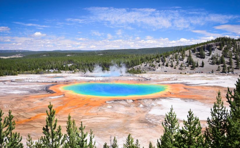
Norris Geyser Basin
At 6am we were both awake and I asked Becky if she was up for getting out early to beat the crowds. She said OK, so by 6:30 we were on our way to Norris Geyser Basin. The entire drive was foggy and mysterious, mainly because of the cold morning air and all of the hot steamy water in the park. We couldn’t see very far ahead of us in Gibbon Meadows and the entire Norris area was shrouded in fog.
Norris Geyser Basin is one of the most popular attractions in the park, and it has extremely limited parking (as do most things in Yellowstone). We definitely made the right move coming early, since we snagged the very closest parking space to the trail into the geysers while the lot was still mostly empty.
Steamboat Geyser
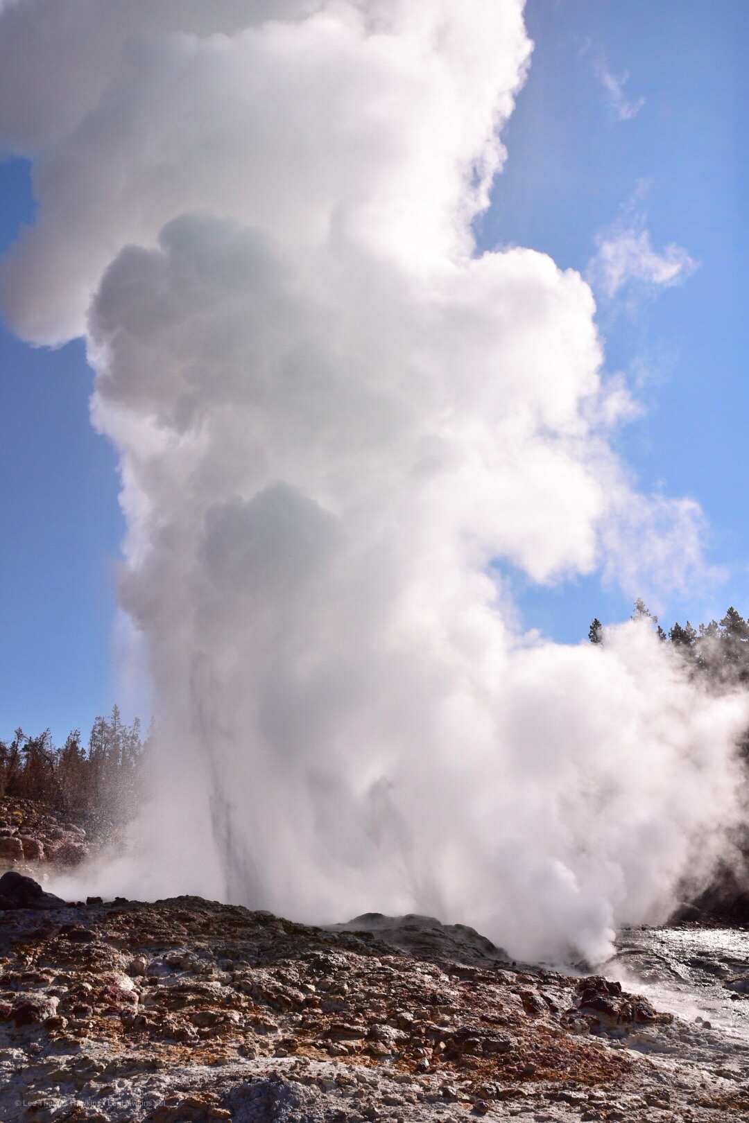
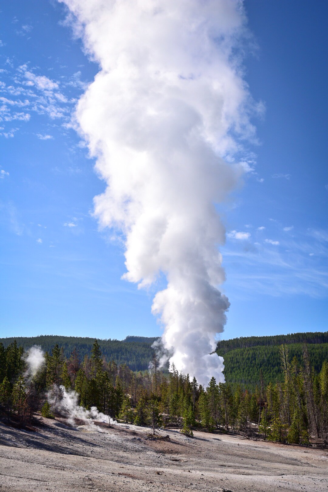
My first thought when we arrived was to check on Steamboat Geyser, the park’s and the world’s most powerful, topping over 350 feet during major eruptions that can last for days. Norris is almost a full thousand feet higher in elevation, so there was ice on the boardwalk leading to Steamboat. I hadn’t considered what this actually meant until we got close enough to the geyser to hear it bellowing water and steam! Sure enough, Steamboat began a major eruption at 10:23pm last night that was still going on this morning!!! People who stayed at Norris Campground a mile away last night said they could hear it when it blew! Even though it wasn’t hitting 300 feet when we saw it, it was still pushing water up exceptionally high and in exceptional volume. What a treat!
Yellowstone National Park’s Steamboat Geyser, the world’s largest, during a major eruption that began the night before.Steamboat bellows an enormous amount of steam during a major eruption.
Last night was not my best sleep. The white noise from the river running was wonderful when I was awake, but too loud and too much like howling wind, so I woke up after only short bursts of slumber. I wish I’d put in my earplugs, I think they would have helped. To top it off, my pad deflated, which just made the bad situation with my back worse.
While the humidity was not much indication, this was our first night at altitude, as Ayres Natural Bridge sits at about 5,000 feet. Usually it’s pretty dry here, but the forecast dew point was actually close to our overnight low. Thankfully, though, dew wasn’t too bad a problem as our tent was dry on top. Since we’re now rather high, it’s time for the peeing to begin, as we have to drink ample water to stay hydrated.
So now you know what motivated me to get up at 6am. After this, I thought about the park gate—didn’t it say they lock the gate between certain hours? Sure enough, the checkin slip says the gate is *locked* from 8pm to 8am—and my notes indicated we needed to leave by 7am! So does that mean we’re stuck here until 8??? Since I didn’t feel a bit like trying to get more sleep and I didn’t know if I should wake Becky up, I needed to investi-gate!
Investi-gate
I didn’t want to leave Becky without the car or wake her up, so I decided just to hoof my way to the gate and determine the situation before proceeding. I guess my attempts to get into better shape before we left paid off, since I had hardly any trouble at all hiking the 1/2 mile or so uphill at 5,000 feet to the gate. Turns out it’s electric, and a car parked in front will trigger it—so we can leave anytime we want—fantastic! Now to go get back to Becky and start packing up camp.
By the way it was a beautiful morning, even though a bit overcast. The clouds and the colored light of the rising sun really made the mountain in the distance to the Southeast look dramatic! My hike also caused me to cross paths with several creatures, including a big black beetle and several rabbits.
Breaking Camp
By the time I returned, Becky was already astir and ready to help break camp. We got everything put together by 7am, but I had to take advantage of the much brighter light to get some photos and video before we left…which didn’t happen until about 7:20 or so.
Pit Stop In Casper
We stopped just inside Casper for gas, mostly so I could clean the windshield and of course, pee again. I really picked the wrong gas station though…an older gentleman stood outside the restroom…and there was a handwritten “OUT OF ORDER” sign on the men’s room door. He sheepishly went into the women’s room, and then came out saying something about the flapper on the toilet…oh man. I walk in, see the cover off of the toilet tank and decide I’ll figure it out, and tried to close the door. Seriously??? The door was not properly hung, so I couldn’t close it! I didn’t have the time to monkey with it, so I closed it as much as possible and hoped for the best. I did have to make sure the flapper in the tank didn’t get hung up on the lever pulling it open, but otherwise everything went fine after that.
I ran back outside to work on the windshield and apologized to Becky for picking the worst possible gas station. I guess it was clean…but they really need a handyman to get things in proper order. Becky came back a couple of country songs later (the pickup truck song really got me working faster) and we got back on the road.
A New Route To Yellowstone (For Us)
Now the usual road to Yellowstone for a lot of people from the East is to cross South Dakota and most of Wyoming on I-90, and then to take either US-16 from Buffalo or US-14 from Rochester. We did that route with US-16 on our first trip back in 2015, passing through Ten Sleep Canyon and Cody. Since we were coming through Casper farther south this time, we would continue to follow US-20 and pass through Cody again. This would give us an opportunity to see some new parts of Wyoming.
I-25 between Douglas and Casper mostly follows the North Platte River, with mountains off in the distance, mostly to the south. After we diverged to stay on US-20, the road basically passes through barren lands without much of a view of anything but grass, sagebrush, and an occasional oil or gas well until you get to Shoshoni.
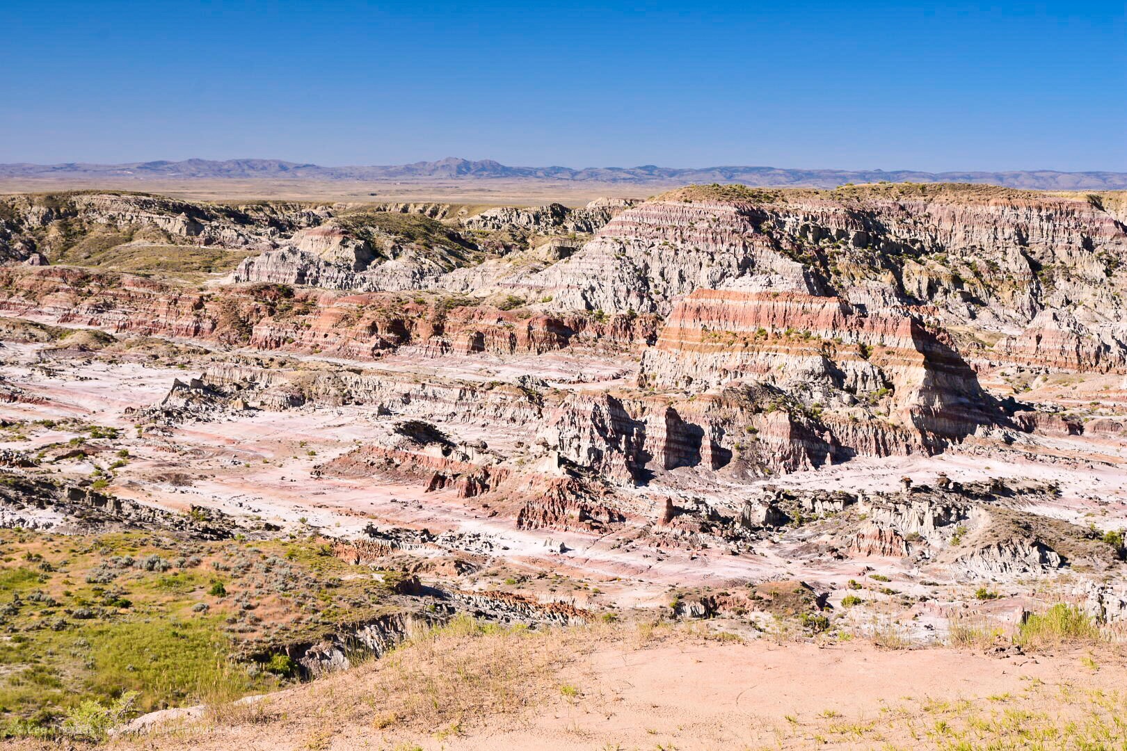
Hells Half Acre
Our first stop, Hells Half Acre, breaks up this drive. This rugged canyon actually sprawls 320 acres, and appears to have at some point had a building there, but all that’s left now is the foundation.
Hells Half Acre on US-20/26 west of Casper, Wyoming
I forgot to mention in last night’s post that I finished packing up by moonlight. The campground at Smith Falls so far as I could tell lacked artificial lighting, so my eyes were able to adjust very well. It’s incredible that a 3/4-full moon could light the night up so well, and for the most part we modern humans have no idea how well our eyes adjust to it because of all the artificial light we surround ourselves with. The funny thing about it is that orange or yellow light from a fire doesn’t prevent your eyes adjusting to the moonlight. Had it not been for me sitting there in just firelight, I don’t think I would have realized how bright the moonlight was.
Getting Started
Anyway, I think I may have actually slept reasonably last night. And my mattress stayed inflated all night too! On last year’s trip I realized it was losing air when we camped at Yosemite. I found a tiny little hole on the bottom and patched it up earlier this season. After two weekend camping trips since, I wondered if a leak might still be present because it seemed to still lose air, albeit more slowly. Perhaps that was not the case.
I stirred around 5:30am, about an hour before sunrise. The moon was gone but the sun had alrighty begun to intrude with first light. The entire campground was quiet with the exception of the tranquil flow of the Niobrara River.
Becky awoke around 6:15. We witnessed some brilliant red colors this morning—I should have thought about that saying, “Red sky in morning, roadtripper take warning,” or something like that. We certainly ran into some weather today…but I get ahead of myself.
What’s With the Humidity?
The first weather we noticed last night was the humidity. Smith Falls State Park is just west of the 100th Meridian, which is about where the altitude of the Great Plains increases and in turn the climate becomes more arid. In general, you can grow crops without relying heavily on irrigation east of the 100th Meridian, but not west of it. We’ve noticed in years past that the air is generally much dryer overall than it was tonight. It felt positively clammy well before sunset—more like an Ohio summer.
When we woke up this morning, our tent was soaked from the dew. We’d left the rainfly open last night to get airflow since it was rather warm. I made the mistake of leaving my sandals out in the open and they were terribly wet. Once we bit the bullet and got down to business, we made short work of packing the bedding and tent, leaving the campground around 7:30am.
Real Food For Breakfast!
Our original plan included a full day of stops at a few more places in Nebraska before heading into Wyoming for the night. One of these was Toadstool Geological Park, which sounded wonderful, but required a 13-mile drive down a gravel road. Maybe we’ll try that in the future during a more normal dry year when the road is less likely to be flood damaged like we saw in the campground in Smith Falls State Park.
Since we’d dropped Toadstool, that freed up plenty of time for us to get real food for breakfast! We headed into Valentine and ate a full breakfast at the Bunkhouse Restaurant in the center of town. The service was great, and the food was good diner fare that hit the spot for us.
The Bryan Bridge
After breakfast we headed south of town a mile or two to check out the Bryan Bridge, which used to carry US-20 across the Niobrara River. On the opposite side of the new US-20 bridge sits an old railroad trestle that now carries bicycles instead of trains.
The entire area around Valentine has incredibly beautiful terrain! The hills around town are lovely, and the Niobrara River seems like a wonderfully quiet place to canoe or kayak through them.
Northwest Nebraska
Not far west of Valentine, the terrain becomes less rugged with more rolling hills and fewer trees. The aridity west of the 100th Meridian certainly becomes apparent. We drove about two hours through another handful of very quiet tiny little towns.
As we approached Chadron the terrain changes again. Along with rolling hills, rocky buttes began to impose themselves on the horizon. Chadron was a bit larger than Valentine and even had Walmart. Here we turned south to visit Chadron State Park.
Chadron State Park
The buttes only became bigger and more concentrated as we approached the park. This area reminds me very much of the drive between the Badlands and Black Hills on Highway 44 in South Dakota and Wyoming. We pulled into the park office, paid the $8 out-of-state day-use fee, and headed up the park’s scenic drive.
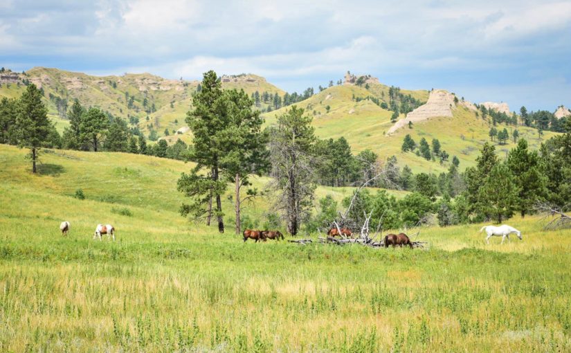
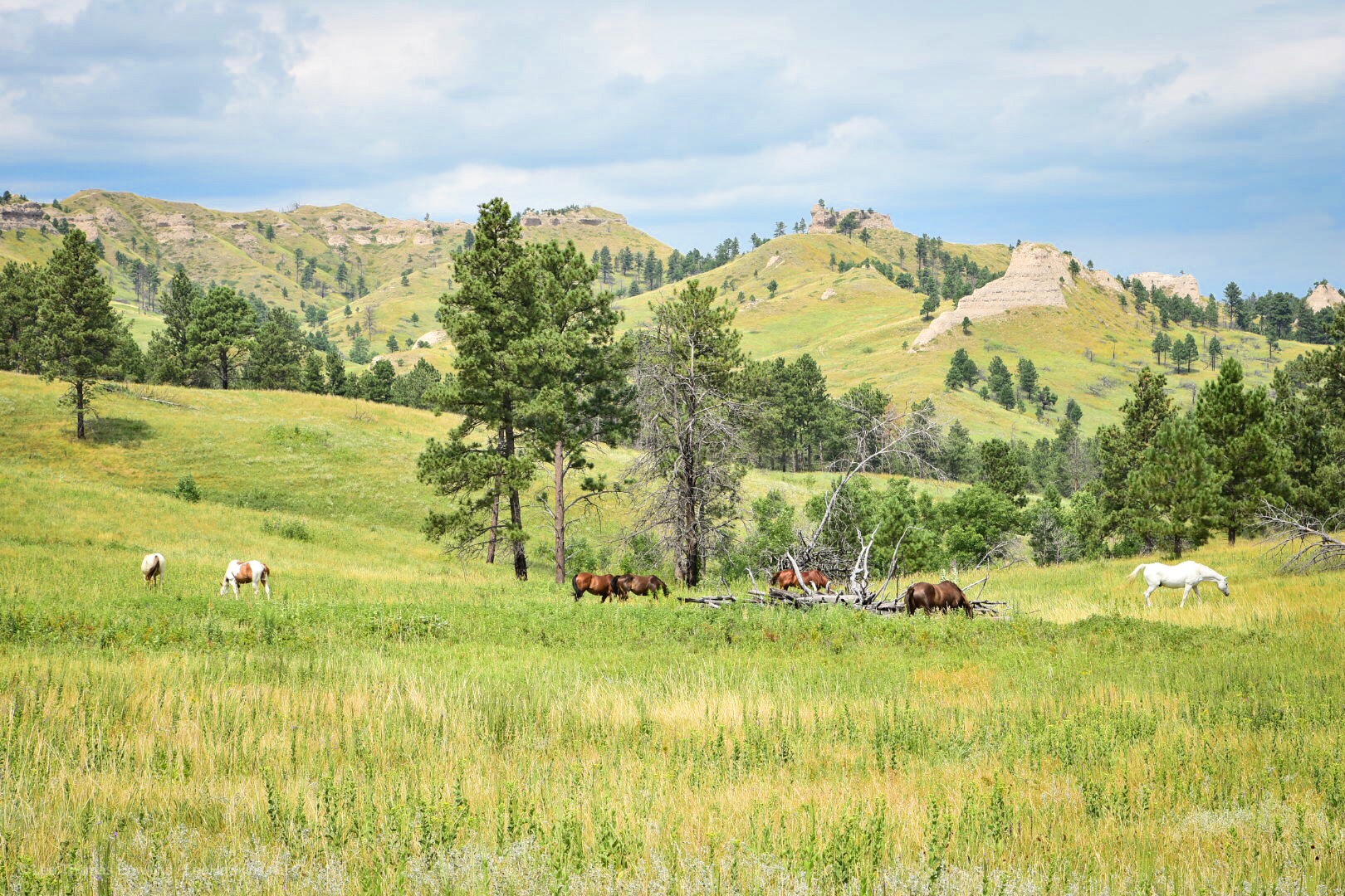
I wanted to see the Blackhills Scenic Overlook, but the narrow high-crested gravel road made us rethink this. We instead continued on the scenic drive past a picnic shelter with a nice retro playground near the horse pasture. We didn’t stay long here since we hoped to get to our campground for the night a bit earlier than originally planned, and we still had one more stop…
Horses grazing in a pasture at Chadron State Park in Northwest Nebraska
We made it…this far! Once we got out of Greater Cleveland, traffic was a breeze, even around Chicago. Incredibly, Becky made the entire 7-hour drive without even a single stop! This got us to our hotel in the Quad Cities last night at 11:30pm local time. Checkin at the LaQuinta Inn Moline Airport was a breeze, and we settled into bed maybe a minute or two past midnight.
Iowa
‘Tis the Season
I haven’t had the best time sleeping lately…it seems 4 or 5 hours is about all I get most nights. I set an alarm for 6:15 with the hopes we could grab a quick breakfast in the hotel lobby and get on the road. My sinuses had other ideas—every year they let me know when August arrives. This morning they reminded me, which made it difficult to exist let alone get up. Becky was feeling it too.
“The World’s Largest Truckstop”
We finally got out the door and back on the road at 7:30am. The Iowa 80 Truck Stop just west of Davenport was our first refueling stop of the trip. It bills itself as “The World’s Largest Truckstop”, with about half a dozen fast food franchises, a ton of retail, a buffet restaurant, plenty of American automotive memorabilia, and of course gas and diesel.
Where We’re Going, We Don’t Need Interstates…
Normally we just follow I-80 all the way across Iowa. This time I wanted to try a different route farther north. US-20 runs from coast to coast—Massachusetts to Oregon—and it passes maybe 50 miles north of I-80 through Central Iowa before running across Nebraska within a few miles of the South Dakota border. Today we’ll head up I-380 to join US-20 until Sioux City, where we’ll diverge on the Outlaw Trail Scenic Byway to follow the Missouri River more closely.
The Great Plains: #NotFlat #NotBoring
I can’t say this enough, but I don’t understand why people repeat over and over again that the Great Plains are flat. I mean, I realize it’s not exactly mountainous (except it actually is in the High Plains!), but most of it has rolling hills. Eastern Iowa is especially pretty where farmers sow their crops to follow the terrain. We usually go through in July. August offers larger and more mature plants, including tasseled corn, but everything is still a wonderful green. When we passed through last September, things definitely appeared less verdant.
Splat 🙁
The weather was mostly cloudy at first. We even hit some rain between Cedar Falls and Fort Dodge. We also hit some gigantic bugs with yellow innards. Yuck. (Turns out these were actually monarch butterflies! Now I feel guilty too! Those poor things have it tough enough!)
Driving Across Iowa on US-20
We found the drive across Iowa on US-20 very pleasant compared to I-80. Traffic is nearly nonexistent past Fort Dodge, and the route is more scenic in the Western part of the state. The only drawback we discovered was the total lack of rest areas…but there were adequate numbers of gas stations all the way up to Sioux City.
Nebraska
At Sioux City we crossed the Missouri River and the state line into Nebraska. After stopping for fuel we diverged from US-20 to begin our journey along Highway 12—the Outlaw Highway—which follows the Missouri River and the state line with South Dakota.
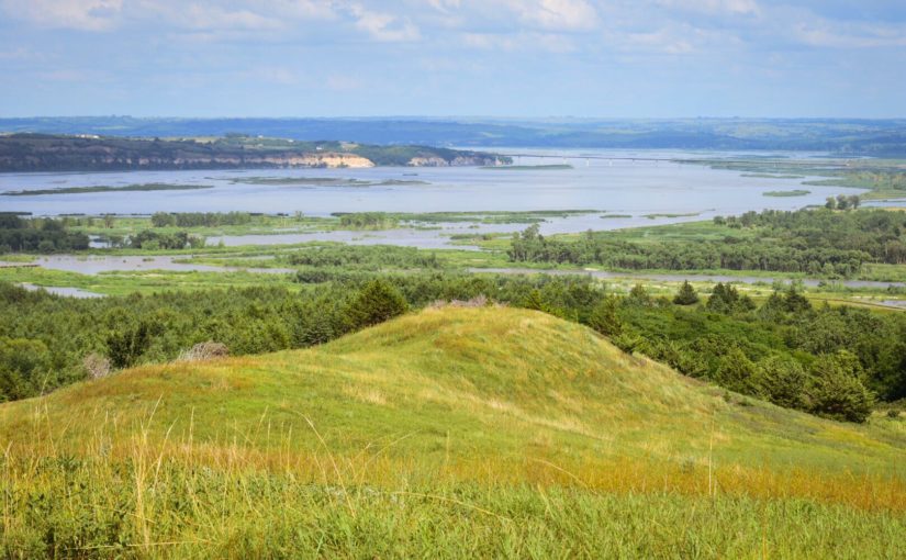
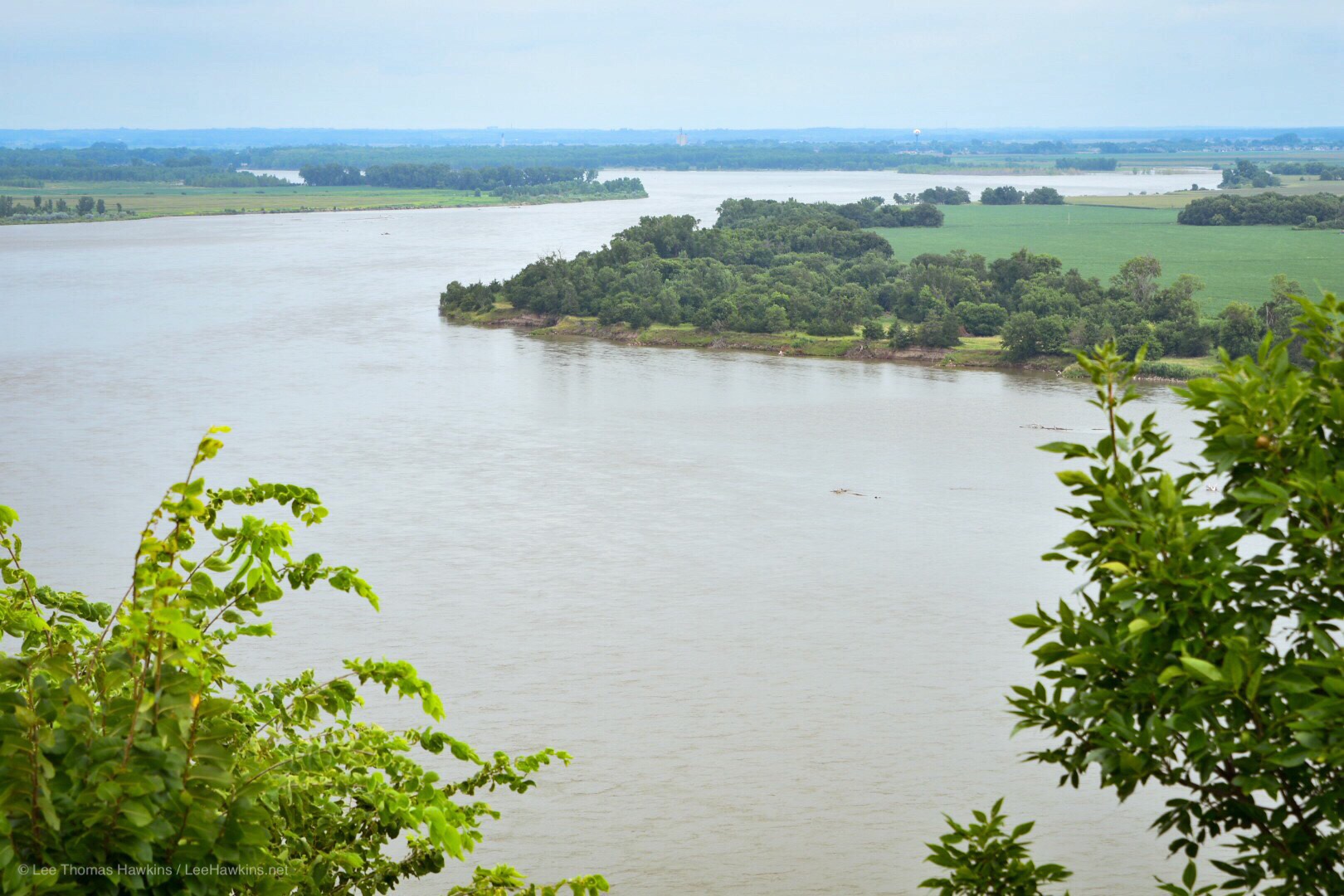
Ponca State Park
Our first stop, Ponca State Park, preserves a section of the River that still looks much the way it did back in the time of Lewis & Clark. We stopped to enjoy the view at the Three State Overlook, where you can see South Dakota and Iowa while standing in Nebraska. This is one of the few places where the Missouri River hasn’t been dammed, straightened, or bypassed with a canal to better facilitate shipping (and flooding). The overcast sky and humidity weren’t the most comfortable, but it was exciting to ponder the beginning of Lewis & Clark’s adventure across the continent, as well as their return through this stretch of river two years later.
So the Cuyahoga County Fair is this week…that’s only relevant because I got caught in far worse rush hour traffic on my way to pick Becky up from work this afternoon. That along with being about 30 minutes behind schedule getting out of the house got us on the road about an hour later than I’d hoped. Traffic on the Ohio Turnpike was slow too at first, thanks to construction.
In spite of all that, we should be able to get into our hotel room at the LaQuinta Inn next to the Moline Airport before midnight Central time. I suppose every hour we’re behind means less pain getting around Chicago…I hope!
Also, I don’t think we forgot anything. I always have that feeling whenever we head out on one of these trips…I probably have problems hahaha! Anyway, we seemed a little more put together this week despite the hectic last month that we had. There were a ton of problems with our car, so we spent a lot of time shopping to buy another one, as well as working on repairs to the old one. We got something I think we’re both happy with, but it really set us back on a lot of work we’d have put in preparing for this trip.
Last year we got a late start and I was way way more stressed out in the process than I was today. This morning we actually had most of the car packed before I drove Becky to work. We haven’t been able to do that in a while! This year it feels like we have a completely different car, even though we still rented a Nissan Altima. I think we’ve had a 2016 for our trips the last couple of years, so we got really used to them. This time we have a 2019 and besides a major redesign of the interior, they’ve loaded this car with a ton of safety features neither of us have ever dealt with before.
I had to dig through the owners manual to understand how the intelligent cruise control system works. It automatically slows you down when you come up behind someone going slower than your cruise setting. That may be a great feature in heavy traffic, but when you could easily change lanes to get around someone it’s kind of annoying. We figured out how to decrease the distance where it starts to slow down, and Becky figured out how to turn off and on some of the other sometimes annoying safety features. At least it has a sunroof…that should be fun.
We have to make a fuel stop before we arrive at our motel in the Quad Cities tonight Hopefully we can get a fair amount of sleep and find some food that gets us going early enough tomorrow. We’re trying a new route across Iowa and Nebraska this year—rather than taking Interstate 80 the entire way, we’re diverging north from Iowa City to take US-20 across. I’m not expecting anything vastly different from the Iowa section than we’d see on I-80, but our route across Nebraska should offer something new! US-20 and Nebraska Highway 12 form the Outlaw Trail Scenic Byway and the Bridges-to-Buttes Scenic Byway, where we’ll follow the Missouri and Niobrara Rivers tomorrow, and pass through the buttes of Northern Nebraska on Sunday.