RealImaginarySmokies Day 7 – Bald River Falls & the Road Home

After packing up at Indian Boundary Campground, we visited Indian Boundary Lake and Bald River Falls in Cherokee National Forest before heading back to I-75. After a stop in Knoxville, we continued north on I-75 across Tennessee and Kentucky to Cincinnati where we picked up I-71. It rained torrentially across much of Kentucky and Ohio before we finally made it home up in Cleveland just after midnight.

Windy Thoughts

I awoke at 4am at Indian Boundary Campground in Cherokee National Forest to a much higher temperature and the wind kicking up…ugh. It had to be at least 60°F, which made me downright uncomfortable until I shed the extra layers I was wearing.

But that wind—it was as if the sky would take a deep breath and then exhale it all in one big long push. The trees swooshed around, and each time I’d tighten up—expecting rain to fall and get our tent all wet just before we’d have to pack it up! I’d hear pattering on the roof of our tent, thinking they were giant raindrops…but they were just leaves. I knew the wind couldn’t be too strong though, because our tent wasn’t flapping like we’ve seen before (De Smet!)—but the pattern unnerved me nonetheless!

With every gust I held my breath, because I just knew we were gonna get it…and then nothing would happen. I wished that I could see a weather forecast or even just the radar…I thought that knowing what’s out there would help me calm down and relax. I kept thinking and working out the physics in my head…I didn’t hear any thunder or see any lightning or smell that ozone smell you get when it’s about to rain…maybe it was just the way wind currents and air pressure worked coming through the mountains? My mind kept racing in circles, so I finally decided to myself that this wind was not going to bring rain right now—it’s probably just a warm front moving through and we’ll be fine.

That wasn’t much solace though. My heart wanted to go along so I could go back to sleep, but every time I’d doze off, the wind would blow hard and wake me up. I started thinking about about how great it would be to sleep in my own bed tonight. Yeah! And I could have cell service, a hard roof over my head, and I wouldn’t feel so disconnected from the rest of the world and all the information I needed to go about my business. Ahhh…yes! It felt wonderful to think such thoughts!

So I decided right then…I was ready to go home. The anxiety of rain, cold, wind, mice, cutting wood, getting stuck with green wood to burn, finding a dishwashing station, not having a clean neat place for a shower…all of that would be gone if we were at home. Home is where my heart is now, so home is where we’ll go! No stop-overs at some other place tonight, just heading straight on home after maybe checking out this area a bit…after all, we were by a lake and among mountains I had not yet seen, no need to waste that. So go see stuff, then drive home. Yeah! It’ll be great!

So when it was light and Becky woke up, we talked about packing up and heading home. She was cool with going back a day earlier than we had to. I know her face still bothered her and made it more difficult for her to enjoy herself. I told her we were only about eight or nine hours from home, but she seemed skeptical. I would have pulled up Google Maps and showed her, but well…you know.

Panos, Wind & Fire

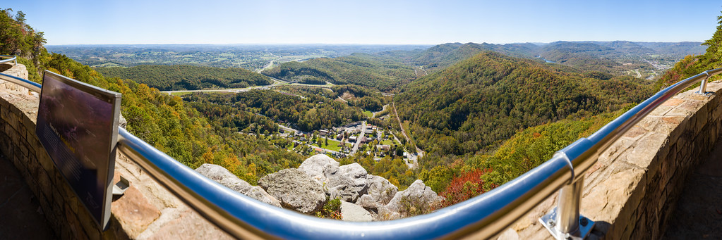
So before we got started on packing up everything inside the tent, I set up my pano rig to get a shot of our campsite with our super-dirty car. We still hadn’t had a drop of rain, but the wind was still blowing and whipping all the trees around, wrecking my shot. I kept running over whenever the wind would die down, but the lulls would never last long enough to shoot all the way around. I eventually gave up and devoted all my energy to cooking some breakfast.

I chopped down some logs to make kindling and got a fire going…sort of. Every time I thought I had it burning, it would die down until it just pathetically smoldered. We got one round of eggs cooked, but for the second round I had to chop up a lot more kindling to get things hot enough again. I had thrown every log but one into that so-called fire and this wood simply refused to burn. I swear that the best way to extinguish any well-burning fire would have been to throw this wood into it! It was the worst firewood we’ve had all year long!!! The label said it was kiln-dried, but I had to wonder if they ever bothered to heat up the kiln…

In the midst of the firewood fighting my fire, the wind died down and just stayed that way. Weird! Thankfully I’d left my pano rig set up, so I ran back over and I think I finally got my shot. At last I can take down the tent!

360-degree panorama of Site 3 in Indian Boundary Campground in Cherokee National Forest. Click and drag to look around. Click the top right button to go full-screen.

A Final Farewell

So with breakfast eaten and our car all packed, there was only one thing left to do. This was the ceremonial burning of our fire-handling logs. They had been pretty good to me, and we’d used them all week. We didn’t do anything crazy…I just rearranged the smoldering wood so I could throw the logs down on top. In my mind, I thought it should be like they were Darth Vader burning on the pyre at the end of Return of the Jedi. Becky and I said nice things about the logs, told them they were good, and watched them burn.

And what a contrast! A minute or two later, the whole thing came to life because of these two little logs…we had a real campfire again! We knew this was too good to waste, so we considered roasting the last of our hot dogs. However, neither of us wanted to dig to the bottom of the car where we’d buried the hot dog skewer…so we said never mind.

Then Becky broke a stick off of a downed limb nearby and fashioned it into a hot dog skewer with her knife…and voila! Hot dog time!

With our completely dry tent in our completely packed car and with our fire now burning brightly…while we roasted our last hot dogs on our last campfire of the season on what was probably our last campsite of the year…a light rain finally started. We were both very happy that it held off just long enough for us not to feel one bit rushed! In spite of our mishaps, the whole week went pretty well overall, and the whole year had brought us a lot of camping in a lot of places and with a lot of friends. It was a fitting finale.

Indian Boundary Lake

While this moment brought a great deal of contentment, the day was not over yet! The rain only lasted a minute or two, so we ate our hot dogs, put out the coals, and moved along to visit the camp store and check out the lake.

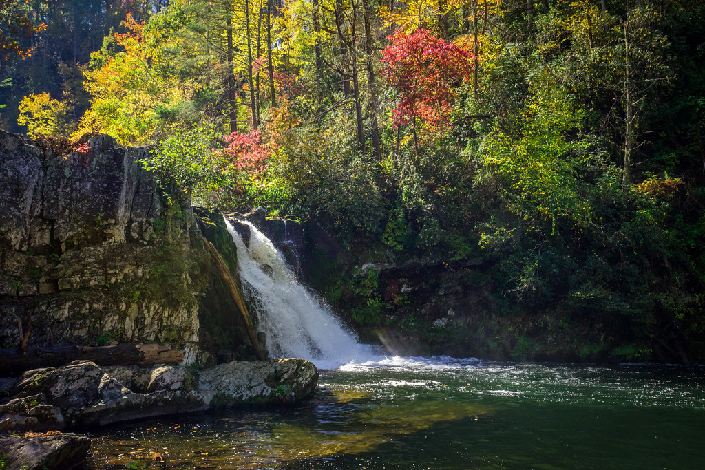
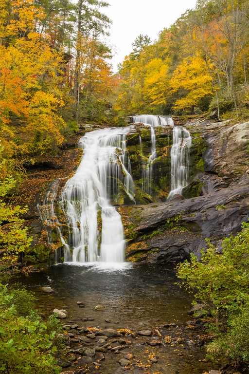
The Indian Boundary Outpost was thoroughly stocked. While not large, it had everything a tenter or RVer would need if something was broken or forgotten—food, firewood, snacks, utensils, air beds, and of course souvenirs. Best of all, they had tons of maps and the lady running it was super helpful at identifying hikes, drives, and waterfalls in the area. She helped us decide to stop at Bald River Falls, a 90-foot waterfall that’s on our way to Tellico Plains and I-75.

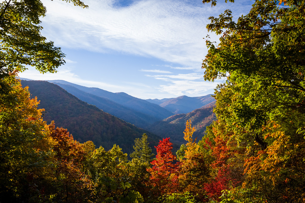
We then drove out of the campground to the beach and picnic area on Indian Boundary Lake. It’s not a big lake, but the beach was nicely maintained. There’s a boat ramp and fishing pier across the lake, with beautiful mountains rising beyond.

Indian Boundary Lake this cloudy morning

Bald River Falls

Bald River Falls

We drove back out to the Cherohala Skyway and cut over to River Road/Forest Road 210, which is a narrow old logging road that follows the Tellico River. Just a couple miles east, the road crosses the Bald River on a bridge offering a perfect view of Bald River Falls. There’s a sign next to the road so you don’t miss it, and a small parking area beyond. It was Saturday, so there were lots of motorcycles, several photographers, and a healthy number of people here.

Things were a bit congested, but still nothing like we experienced at Great Smoky Mountains National Park. I was able to shoot some stills and a 360° panorama just before the crowds built up and the rain started again. Rather than cutting straight back over to the Cherohala Skyway/TN-165, we followed behind a few motorcyclists on River Road/FR-210 as it wound alongside the scenic Tellico River.

Continue reading RealImaginarySmokies Day 7 – Bald River Falls & the Road Home

RealImaginarySmokies Day 6 – Exploring the Ghost Town of Elkmont & Cruising the Cherohala Skyway

We departed Elkmont and got stuck in traffic for 90 minutes heading up to cross the park on Newfound Gap Road. We then drove US-74 west to NC-28 and NC-143 to Robbinsville. Finally, we drove the spectacular Cherohala Skyway across to Indian Boundary Campground in Cherokee National Forest.

Do We Have a Mouse?

It’s always a good night for me when it’s warm enough that I don’t need to wear socks. Last night was one of those nights. At 4:45 I was awake, and amid the still darkness, I wondered if we had caught our mouse. We’d been trying to catch him for the last two days to no avail. He thwarted our first attempt and managed to make off with every bit of the bait.

After finding my socks inside my sleeping bag, I quietly exited the tent, trying not to disturb Becky. I walked up to the car, turned on my LED lantern, pulled on the car door handle AND—it was locked! Crap! Forgot about that…this was certainly less dramatic than I’d imagined!

Our second, somewhat more improvised mouse trap lying behind the driver seat (Photo by Becky)

I retrieved my keys from the tent, unlocked the car this time (that Toyota beep is awful loud in a dead-silent campground!), pulled on the handle AND—saw that the bottle and the sticky trap were still together, but totally jostled out of position from where I had wedged it on the floor behind the driver’s seat. The outside fringe of the sticky trap had been gnawed around, just like the day before, and then I saw the box rock! The mouse was still there, but was he inside?

I slowly picked up the trap and peered in through the front—and sure enough, a long tiny tail on a little tiny mouse about two or three inches long was stuck inside! YES!!! We finally got him!!! He was small enough that he probably would have been able to get inside the bottle and eat the bait with no problem had I not added the sticky trap as an extra hurdle. I set the trap down on the picnic table and went over to the tent to share my jubilation with Becky. “We got him! Do you want to see it?”

Now What?

When Becky said no, my mind moved on to letting him out of the trap. I hadn’t given much thought to this until now—and I felt profoundly sad and even guilty. This poor scared, tiny little creature was stuck in my trap and no longer in my car, but now I have no idea how to let him go. While he was obviously quite strong to be able to jostle a 12-ounce glass bottle around, he was too delicate for me to free from the sticky trap without some serious injury; furthermore, I’d probably get my fingers bitten up in the process. I could just leave him for a predator, but chances are that it too would get stuck in the trap, or worse yet the bait in the bottle could attract a black bear to investigate.

I was all out of ideas, I had no Internet service and therefore no Google, and it was still before 5am…so I asked Becky what I should do. She told me to just put him in the dumpster. 🙁 I felt terrible about it, but that’s what I did. I hoped he would break loose in there, but I didn’t think that was likely.

I concluded that I hate these sticky traps, and that I’m never going to use one again. I have no idea what I could have done better to deal with a mouse taking up residence in our car on a camping trip, but I knew the way I chose was too inhumane to use it again. (UPDATE: I Googled later and found out that you can release a mouse from a sticky trap, but it’s not very easy to pull off on the road. If I’d known, I’d have tried to get him out.)

Remember folks: keep your food safe in hard-sided lockable containers, and don’t leave your car open long enough for wildlife to move into your car for the winter. They can make a real mess, and it’s hard to get rid of them. Out West they have a saying, “A fed bear is a dead bear,” and that seems to be true for all wildlife. I know this experience has made us extra careful on the road and at home.

Shooting Elkmont

After crawling back into bed, I got up again when my alarm went off at 6:30. This was our last day here at Elkmont, and I wanted to take advantage of the still air and soft, even, early light to shoot some panoramas of our campsite and the abandoned buildings. Even the slightest breeze makes it difficult to get a clear 360° image, and the winds have been almost nonexistent first thing in the morning. I had my pano rig set up not long after first light, and thought that shooting our campsite from the top of our picnic table would offer a good vantage point. This is usually no big deal, but today I did something stupid and earned my injury for the week…

The Picnic Table Incident

I was standing on top of the picnic table next to my camera and decided to walk around and check the leveling on my panoramic head…I took my first step, and realized I had made a terrible mistake! As I set my foot down onto nothing, I thought, “Oh no, well I guess I better be ready to land on the bench!” And then I realized…I’d missed the bench! I was going all the way down! In this split second, I realized I’d better be ready so I don’t twist my body all up and really get myself hurt.

So I came down on the one foot, turning myself enough that my upper body continued to fall backwards, past the bench. This saved me from bumping my head, tearing my groin, or twisting a joint, but it meant breaking my fall with my legs on the bench and my hands on the rocky ground! Ach! And when I landed, I looked up just in time to see my camera and tripod coming down after me!

Thankfully, everything landed softly on top of me. No damage came to my equipment or me, save for one sore wrist and a gravel rash on my hands. After the adrenaline passed a bit, I of course set up again and got my shot on top of the picnic table. Then I moved on to the Elkmont Historic District…

360-degree panorama of Site N1 in Elkmont Campground. Click and drag to look around. Click the top right button to go full-screen.

The Saga of Elkmont’s Appalachian Club and the Creation of Great Smoky Mountains National Park

Elkmont’s oldest structure, the Levi Trentham cabin in Daisy Town, built in 1830

The Sneed cabin in Elkmont’s Daisy Town district

The Hidgon cabin in Elkmont’s Daisy Town district

A children’s playhouse in Elkmont’s Daisy Town district called “Adamless Eden”

I know that heading is a mouthful, but there’s a story here with all of these abandoned buildings and the old cemetery I found on Tuesday. You see, back in 1908, Colonel Wilson B. Townsend set up a logging camp where Elkmont Campground is today. Lumber was transferred to his sawmill by a railroad he built and extended to Knoxville. When most of the timber was gone, Townsend advertised Elkmont as a mountain getaway. In 1910 he sold land to an affluent group of Knoxville outdoor enthusiasts who formed the Appalachian Club. They built the Appalachian Clubhouse and several vacation cabins, creating the small neighborhoods of Daisy Town, Millionaires Row, and Society Hill.

In the 1920s, the young National Park Service sought to create a national park in the Eastern United States. The movement to create one in the Great Smoky Mountains was started by certain members of the Appalachian Club. Due to maneuvering by politically influential members who desired to create a national forest rather than a national park, cabin owners in Elkmont were allowed to obtain lifetime leases when the park was created in 1937. Meanwhile, residents in less affluent areas like Cades Cove were flat-out evicted through eminent domain.

The last lease in Elkmont expired in 2001, which would have allowed the park to proceed with demolition plans it had at inception. However, some leaseholders’ descendants succeeded at placing Elkmont on the National Register of Historic Places in 1994. This caused a 15-year debate that finally resulted in the preservation of most of Daisy Town and two other structures further up the mountain. The rest of the buildings will be demolished early in 2017.

I unfortunately did not get to photograph inside any of the abandoned cabins, as all were posted with “NO TRESPASSING” signs, and several of them had collapsed floors and roofs. Things were still plenty creepy though! I did, however, shoot a panorama inside the Appalachian Clubhouse, which was restored in 2009. This was thanks to a ranger who was kind enough to let me in while he performed some maintenance.

360-degree panoramas of abandoned vacation cabins in Elkmont’s Society Hill district. Click and drag to look around & click the arrows to see a different location. Click the top right button to go full-screen.

Continue reading RealImaginarySmokies Day 6 – Exploring the Ghost Town of Elkmont & Cruising the Cherohala Skyway

RealImaginarySmokies Day 5 – Cades Cove & Abrams Falls

In spite of yesterday’s misadventures, we got an early start and headed to Cades Cove. We hiked to Abrams Falls at midday and returned to Elkmont for an early dinner and our biggest fire of the week.

Did We Catch It?

My very first thought this morning was, “Did we catch it?” Yesterday we discovered a mouse had moved into our car and probably intended to spend the winter there. Rather than enjoying a hike here in the Great Smoky Mountains, we spent most of the day rearranging and cleaning everything so we could protect our food and be able to tell if our little friend was still at large. Since he loved my hot dog buns, we used a piece to bait a sticky trap that I placed on the floor behind the driver seat.

I was up before dawn and decided to check the trap before I walked to the restroom. I opened the door AND…the trap was gone?!? What?!? I moved a few things around and found the trap lying behind the car jack under the seat…and the bait was completely gone. There were gnaw marks around the paper with a couple of turds inside, but no mouse. Argh! I tossed the trap and went back to the drawing board…

Our new and improved trap…bait in a bottle, with a sticky trap gauntlet around the neck (Photo by Becky)

Obviously this little guy was stronger and smarter than I realized! While I wanted him out of my car, I had to respect his resourcefulness. We had some empty 12-ounce bottles, so I stuck another chunk of the hot dog bun deep inside on of them, and stuck the opening into the sticky trap. Now he’ll have to get past the sticky trap twice, and he’ll have to risk getting stuck inside the bottle. I actually hope he does get stuck inside the bottle, because it’ll probably be easier to let him go. I wedged my new and improved trap underneath some stuff behind the seat and the waiting game began again…

Assessing Becky

As if battling a mouse living in our car wasn’t enough yesterday, Becky battled with a log she was cutting—and it drew blood. She was OK, but she got a cut inside her mouth when it whacked her teeth, and she had a small cut above her lip. When I saw it happen I thought it would be much worse—but it turned out that there were no teeth missing and no eyes put out. Before this and the ensuing hubbub occurred, we’d planned to get up before dawn this morning to beat the crowds to Cades Cove. This is our last full day here before we move on tomorrow to Cherokee National Forest.

Since we did get to bed early and Becky was doing OK last night, I checked to see if she thought she was still up to going now. She didn’t say much, because things still hurt quite a bit, but she was good to go. So we got on the road at about 7-7:30.

Cades Cove

From everything I’ve read, Cades Cove is the stuff at Great Smoky Mountains National Park. I’ve seen a few pictures and read that there are animals and old farms to see, but I wasn’t sure I understood the draw of this part of the park thus far. I figured maybe I would after seeing it with my own eyes.

We pulled in not long after 8am and immediately began the Cades Cove Loop Road, which runs one-way for 11 miles around the area. It was pretty country, with forested hills to the north, mountains to the south, and lots of clearings in between. Some areas were pastured off for horses, and we stumbled across a few deer. Unfortunately I didn’t get any photos because I was driving. About a mile or two in, my curiosity took us down a road that turned out to be a cutoff to the other end of the loop…which led us back to where we started by Cades Cove Campground…whoops!

Breakfast at Cades Cove Campground & Picnic Area

At the time I was fine with this, because we could take this opportunity to restock the ice in our cooler and eat some breakfast. While the prices are higher, concession operations at Cades Cove Campground are much more extensive than at Elkmont. The store here is big enough that you can actually walk into it, there’s a small eatery with ice cream and $5 hamburgers, and they offer bicycle rentals. I grabbed a bag of ice and drove us over to the nearby picnic area where we could dump the cooler.

Once the cooler was taken care of, I put together a turkey sandwich while Becky made a protein shake. I’m sure glad she brought her protein powder, because her mouth still hurt too much to chew anything. Her lip was pretty swollen, and her cut would bleed a little, but it was starting to heal up. After our peaceful little break, we got back on the road at close to 10am.

Gridlock, Thy Name Is Cades Cove

By now, however, hoards of people had arrived to bask in the splendor—and the gridlock—of Cades Cove. The speed limit on the hilly winding loop is 20 miles per hour, which seemed totally realistic an hour or so ago. Now things had slowed down to a 5 mile per hour crawl. Copious signs indicate that slow-moving and stopped traffic must pull off to let others pass, but few actually do. Most people looked over the age of 55, and drove like they had all the time in the world.

We did see more than brake lights and full-sized cars though. Besides spotting a few more deer, we saw a bear that had been tranquilized by park rangers. Alas, Becky was not yet up to driving, so I was unable to get any photos.

The traffic really killed the experience for me though. Most people drove like aimless wanderers, starting and stopping and slowing down for no apparent reason, not paying attention to the road, and completely oblivious to everyone else. I know I could have moved faster on a bicycle, but that too would have been terrifying because of all the absent-minded motorists. I really feel like the driving sucked any joy I might have felt over Cades Cove completely out of me. Some people may hate me for saying this, but I really hope that one day soon, Cades Cove will be restricted to shuttle buses, bicyclists, pedestrians, and horsedrawn carrages at the busiest times. I don’t think an 11-mile traffic jam should be a national park experience. My thought is that if you don’t enjoy traffic, and you can’t get to Cades Cove at the crack of dawn or during the off-season, don’t even bother with it—it’ll just suck the life out of you.

Abrams Falls Trail

Abrams Falls Trailhead, on the far end of the Cades Cove Loop Road

Now we finally get to the good part of the day! After rounding the halfway point on the Cades Cove Loop Road, I told Becky there was a trailhead coming up where we could hike 5.2 miles to a waterfall. She was game, so we took the turnoff and found a spot in the gravel parking lot. We were still dressed for the chilly temperatures this morning, so we took off a few layers of clothing besides filling our water bottles and packing some trail mix for the hike.

The Abrams Falls Trail starts out around 1,700 feet, much lower than our hike from 5,000 feet at Newfound Gap two days ago. The trail doesn’t really gain elevation, but it does sink 600 feet or so by the time you reach the falls. The trail follows Abrams Creek, straggling some very rocky terrain. You’ll definitely want to wear a good pair of shoes for this hike. The trail rolls along at first, but then you go down and then back up two fairly strenuous hills before you go down a final hill that puts you by the falls. That last hill is a doozie on the way back, but the hike and the waterfall are worth it.

The trail crosses some very rugged terrain. At the top of one hill, you have to cross this notch in the rock to continue!

At the bottom of each ravine you cross a stream on a log like this one.

The trail offers a few vantage points high above Abrams Creek and the forest canopy.

Continue reading RealImaginarySmokies Day 5 – Cades Cove & Abrams Falls

RealImaginarySmokies Day 4 – Mouse In Our Car

Nothing important happened today…because we now have a mouse living in our car…and Becky got hit in the face…it wasn’t me, I swear!

Thinking Back to Last Night

When I got up this morning, my first thought on the way to the restroom was to get a fire going to cook up some hot dogs for breakfast. This was simple enough…until I started rummaging through the car to gather up some buns and condiments…and then I recalled a couple of things from last night…

It was well after dark when we got back from our hike yesterday. While we prepared dinner, Becky drew my attention to a ragged paper towel lying in the back of the car. She thought it looked like an animal did it and suggested that we may have a mouse. I was too tired and didn’t even want to consider the possibility, so I blew it off. Another thing I remembered was that a couple of my hot dog buns looked like a chunk had fallen off, but I was tired and it was super dark—so I blew that off too. Either way, we ate dinner, packed up the car, and everything seemed totally fine…

My hot dog buns! 😮

Well, this morning I knew that Becky was right…my hot dog buns were obviously compromised (and I ate some last night, ewww!!!) and now that I knew to look, I’d found what were probably mouse droppings. Uggghhh. Not good!

Assessing the Situation

A mouse was living in our car, and dug around in the foam under the seat!

Right away, we began taking things out for inspection. Our breakfast fire was burning well right now and I was too hungry and frustrated to be all that useful. So Becky told me to roast a couple of hot dogs and eat them (sans bun, obviously) while she continued with the car. There were signs that the mouse had been all over our stuff in the back, but thankfully our utensils were all packed into hard cases and the only food he got into was my hot dog buns. He also dug quite a bit into the foam on the bottom of the driver seat, probably looking to make a nest.

Normally the hot dog buns would have been packed into another hard-sided tub like the utensils, but Becky had packed the costumes she’d made for Saturday’s Star Wars party in it instead. We bought most of our groceries for the week in Knoxville on the way to the park, and since the food tub was already occupied, the non-refrigerated stuff just sat in a grocery bag. Since mice are often looking for warm places to winter, and are constantly looking for food, our car had to look like the jackpot to our furry little friend.

Even after turning the car upside down (and banging on the driver seat in case he’d made a nest inside), we figured he was hiding safely in any number of nooks and crannies we didn’t know about. This mouse was going to continue making a mess of our car if we didn’t get him out, and the only way that was going to happen was if we trapped him. I sat down to think and make a list…

Continue reading RealImaginarySmokies Day 4 – Mouse In Our Car

RealImaginarySmokies Day 3 – Newfound Gap, The Jump Off & Clingmans Dome

After a late start, we made our way to Newfound Gap with a brief stop at Sugarlands Visitor Center. From Newfound Gap, we hiked the Appalachian Trail to the Boulevard Trail, and made our way to The Jump Off. After hiking back to the car, we made a short trip to Clingman’s Dome, and then made a quick stop in Gatlinburg on our way back to Elkmont.

Home Sweet Campsite

As forecast, our first night in Elkmont Campground was quite cold! The chill made it difficult to get moving any earlier than 8 o’clock this morning, just a bit after sunrise, even though we got to bed at a good time last night.

It was nice that this was going to be home base for several days! There weren’t many nights where we stayed put on our RealImaginaryWest trip last summer. I don’t mind moving around too much, but it is time-consuming to pack up the bedding and the tent, drive to the next location, and then unpack and set up again. Another problem with moving around is that we have to find firewood again if we move very far.

Fueling Our Fires

Firewood is something I try to be a good boy about, even though it’s a real pain sometimes. Campers like us have crisscrossed the country with firewood from home, sometimes spreading invasive pests like insects and fungi. These can and do have devastating effects on forestland. Ever since we started camping, we have always been diligent about acquiring firewood locally. It helps that our car is really only big enough for all of our camping gear and food. The times when it’s been really tempting for us to move firewood is when we’ve had some left over and we’re headed to camp in the next state. The rule of thumb I’ve seen is that you don’t want to transport wood more than 50 miles—but you may not be able to travel even one mile with it, depending on where you are—so you want to be sure! It’s totally worth the effort for us to know and comply with the law so that we aren’t responsible for the demise of the beautiful places we visit.

This year there’s a new regulation at Great Smoky Mountains National Park that requires that all firewood brought in must be heat treated and certified as safe by the USDA. The only other option for campers is to find firewood inside the park. Now back in Ohio, state parks tend to prohibit campers from gathering firewood. But when we were out West, we were allowed to gather dead-and-downed wood in Yellowstone and Grand Teton National Parks. They have the same rules here at Great Smoky Mountains National Park, so I brought my trusty sierra saw so we could save some money on firewood. Since this park is at a much lower and warmer elevation and in a much wetter part of the country, I knew it might be tricky to find dry wood that hasn’t already started to rot…but I was optimistic.

A Fence?

In my search, I made a strange discovery…I walked back into the woods directly across from our campsite, which took me up a hill…and to an old wire fence. I knew we were deep within the national park’s boundary, so it was strange that there would be a fence in a random area I figured for backcountry. After I found an opening, I saw that this was an old cemetery. I thought it was strange indeed to find a cemetery inside a national park, but Great Smoky Mountains National Park was created in an area that most definitely had to have had at least some settlement beforehand. While most were from the early 20th Century, a few were as recent as the past five years…further compounding the strangeness.

My curiosity wore off when my hunger reminded me that I was on a mission to gather wood to cook breakfast, so I walked out the gate on the gravel drive out of the cemetery and down a hill. I found several good small trees a short distance from there and cut a couple of long segments that I could drag or carry back to camp. I’d cut these up and we’d have more wood to supplement what we’d bought last night.

Checking In

Since we’d arrived after the camp office closed last night and our reservation tag wasn’t up on the after-hours board, I had no idea how to tell anyone we were here until this morning. While we were finishing up breakfast, someone came by and told us that we’d need to check in by 11. This seemed simple enough…

When I went down to the camp office and told them about my reservation, they scoured their printed lists and still couldn’t find me. I told them I booked on Saturday morning, but I didn’t have any way of pulling up the confirmation because I don’t have Internet service on my phone. I was surprised that they still used paper for all of this, seeing as reservations are all done by phone through a call center or online! Eventually they did find my reservation, and they set me up with a tag for our site. This stressed me out a bit, but everything was fine in the end.

Getting Out…Slowly…

I was really excited to explore the hiking options here at Great Smoky Mountains National Park, but I found the volume of possibilities overwhelming. Since we’d decided to come here so last-minute, the only preparation I’d managed before we got here was to find an online trail guide and cache a few of the descriptions on my phone. Unfortunately, collecting wood, cutting it, checking in, deliberating over what to do, and our slow and easy pace with breakfast this morning took up the first half of our daylight before we knew it. It was well after noon, and we needed to head out very soon if we were going to get any kind of a hike in before sundown at 7 o’clock.

The views along Little River Road from Elkmont to Sugarlands Visitor Center put the fall foliage on magnificent display!

I finally settled on a hike that departed from a trailhead at Newfound Gap. So we cleaned up our campsite, packed up the car, and headed out. Under ideal conditions, it was a 20-mile, 40-minute drive down Little River Road to Newfound Gap Road. It seemed easy-peasy, but this was when we first discovered how bad the traffic gets here! We decided to stop at Sugarlands Visitor Center, which is near the corner of the two roads. I never imagined that traffic backups could be so bad in a national park, but it took us at least 10 minutes or so to advance from being able to see the visitor center to being able to turn into its parking lot! The particular shame of the matter was that we had to get in line again in order to get back to Newfound Gap Road…cringe!

Not long after we hit the traffic jam, we came into the range of civilization and our phones began to explode with pent-up text messages. While I had only a few, Becky had tons from her friends about the Star Wars trailer the night before. One from Jenny was actually important though—last night, she was supposed to buy tickets for opening night in December—but she wasn’t able to because so many people tried at once that several ticket sites crashed! So we didn’t actually get tickets until today, but we did get them. While we were in the visitor center parking lot, we were able to get a strong LTE signal that allowed Becky to get the new trailer to play on her phone…so we finally got to see what we’d been waiting so many years for!

Anyway…this ate up even more time, and we didn’t get back on the road until 2:30pm…and we didn’t get up to Newfound Gap until almost 3 o’clock. This left just barely enough time for a good hike.. I figured we could get to The Jump Off, which is a 6 1/2 mile round trip, mostly to the east on the Appalachian Trail.

The Appalachian Trail to The Jump Off

The Appalachian Trail, often referred to as “the AT”, is a 2200-mile hiking trail that extends along the Appalachian Mountains from Springer Mountain in Georgia all the way to Mount Katahdin in Maine. Its route traverses Great Smoky Mountains National Park, with a major trailhead at Newfound Gap. We’ll hike on it for our very first time today, using a 2.7-mile section on our way to The Jump Off.

Looking east from the parking lot at Newfound Gap provided a splendid view of the colorful trees on the North Carolina side of the park, as well as the moon just above the horizon.

Becky poses before our first hike on the Appalachian Trail. It’s 1,972 miles to the end of the trail in Maine, but only 3.25 miles to where we’re going!

Continue reading RealImaginarySmokies Day 3 – Newfound Gap, The Jump Off & Clingmans Dome

RealImaginarySmokies Day 2 – Cumberland Gap & Camping in Great Smoky Mountains National Park

We continued south on US-23 into Virginia and cut west on Alt-58 and US-58 to Cumberland Gap National Historic Park, where Virginia, Kentucky, and Tennessee all meet. After enjoying the view there at Pinnacle Overlook, we stocked up on groceries in Knoxville and drove through Townsend into Great Smoky Mountains National Park, where we set up at Elkmont Campground.

In Search of Breakfast

We spent our first night on the road in a warm cozy room at the Eastern Heights Motel in Ivel, Kentucky. We were up bright and early at 6:30am and got on the road just before first light at 7:15am. An early high fog hung just over the hills, shrouding the tops in mystery. About a half an hour after we got going, the sun quickly burned it all off.

We decided to start our day by looking for breakfast. I preferred finding a mom & pop greasy spoon over a national chain place. I expected that there would be plenty of these along US-23, but I was hard-pressed to find any using Google Maps the night before…maybe they never got on the map? So we kept driving south along the highway, keeping our eyes open for prospects.

As we came up to Pikeville, about 10-15 miles from our motel, we decided to exit and search there in hopes of finding something. What I didn’t know is that Pikeville is a more sizeable college town. While there were large sports facilities, parking decks, and big-brand hotels, there was not much in the way of restaurants—especially for breakfast. On the main drag that appeared to be where the US highway used to snake through, we did find Roasted, Coffee and Cafe. However, I didn’t see any breakfast choices that appealed to me for the $5 price tag. So Becky bought her usual espresso and we continued south.

Eventually, we began ascending further and further up hills in the mountains until we went over Pound Gap and crossed into Virginia. Mom & pop dining options along the way were sparse, and we often missed them until we were about to pass them at nearly freeway speed…so it was after 9am and I was still quite hungry. Finally, near the town of Wise, we passed through a commercial strip area where I settled for Huddle House. While the food wasn’t super spectacular or super cheap, it did hit the spot so we could continue on our way.

Morning fog lingers over a valley to the south of Pound Gap.

It wasn’t far to the south where we finally diverged from US-23 at Big Stone Gap and started following Alternate US-58, which is known as Trail of the Lonesome Pine Road most of the way. We passed through several quaint little old valley towns with some beautiful brick buildings right up against the street. In Jonesville, the alternate leg of US-58 joins the mainline highway again and we began following the Wilderness Road. After we meandered our way through countryside and a few more hamlets, we arrived at Cumberland Gap National Historic Park.

Cumberland Gap National Historic Park

Now the Wilderness Road was one of only two good routes across the Appalachian Mountains into Kentucky (the other was the Cumberland Road, which later became part of the National Road that went across from Cumberland, Maryland). Daniel Boone was the man hired in 1775 to blaze a trail that opened up settlement in Kentucky, and that trail became known as the Wilderness Road. It crossed the mountains at Cumberland Gap, which is now the site of a national historic park run by the National Park Service.

Cumberland Gap had been used by Native Americans to cross the Appalachians long before the colonial era. After Daniel Boone carved his trail, it was later widened to allow wagon traffic to pass. It held a great deal of strategic significance during the Civil War, changing hands multiple times. When the US Highway System was created in the 1920s, Cumberland Gap carried US-25E. The Wilderness Road across Cumberland Gap was restored to its historic appearance as a wagon trail in 1996, when US-25E was rerouted through the new Cumberland Gap Tunnel.

Cumberland Gap Tunnel

Inside the Cumberland Gap National Historic Park Visitor Center

Fern Lake between the trees at Pinnacle Overlook

When we arrived, we passed back into Kentucky through this tunnel, and exited the highway to go to the Cumberland Gap National Historic Park Visitor Center. Besides taking a quick look around, I asked a ranger about which parts of the park were the best. It was already about noon, and we still had at least 2-3 hours to drive and a stop for groceries before we made it to Great Smoky Mountains National Park…so we didn’t have more than maybe an hour or two here if we were going to beat rush hour traffic out of Knoxville. The ranger said that hiking across Cumberland Gap doesn’t offer much to see besides the trail itself—but she definitely recommended that we drive up the mountain to Pinnacle Overlook.

So we set out on the winding switchback road up the mountain to a parking lot with ample space. Several short trails, including one that is handicapped-accessible, took us just over the Virginia state line to Pinnacle Overlook. The view here did not disappoint! You can see for several miles across a few towns, countryside, and forested hills to the south, including Tri-State Peak, where the borders of Virginia, Kentucky, and Tennessee all come to point, and tranquil Fern Lake. I spent a good hour photographing from the vantage point here, since it was a relatively clear day and lighting conditions were rather favorable.

Hey, a stranger we met snapped a decent picture of us!

Becky with one foot in each state on the trail back to the parking lot

Overlooking Tennessee and Kentucky from Pinnacle Overlook in Virginia…I will post a link to the full-res version (1.2 gigapixels!) when I get it uploaded…

Continue reading RealImaginarySmokies Day 2 – Cumberland Gap & Camping in Great Smoky Mountains National Park

RealImaginarySmokies Day 1 – The Scioto Valley & Eastern Kentucky

We followed Riverside Drive along the Scioto River into Downtown Columbus, where we headed south on US-23. We then took US-23 through Chillicothe and followed scenic SR-104 out of Waverly and into Portsmouth. After dinner in Portsmouth, we took US-52 along the Ohio River, crossing into Eastern Kentucky at Ashland to follow US-23 south to the Eastern Heights Motel in Ivel.

Starting Off Around Columbus

So there’s a twist for our last road trip this year! Rather than starting out from home, we start out today from Delaware, Ohio, where our friends Justin and Jennifer live. Jennifer organized a Star Wars-themed costume party in nearby Columbus last night. Besides not wanting to miss hanging out with one of her best friends, Becky is an avid cosplayer and a rabid Star Wars fan. Some fans wear costumes to celebrate their favorite sports franchise, while Becky loves getting everyone in costume to celebrate her favorite movie franchise. I always liked Star Wars too…and will say that it is more fun this way!


Anyway, we spent the night at Justin and Jennifer’s house last night, putting us about an hour or so closer to our destination for the night, which will be some as yet undetermined motel. Rather than taking freeways, we’ll mostly take US-23 the entire way, which will take us through parts of Ohio and Kentucky that neither of us has ever seen. I’m not sure where exactly we’ll stop, because I honestly have no idea how long we’ll spend at stops along the way. And we’re getting a motel because tonight will be the first freeze of the season in much of the Midwest and Appalachia. The weather warms up over the course of the week, and should be just fine for camping.

Following the Scioto River

We started out by following US-42 to SR-257/Riverside Drive, which eventually becomes US-33 and Dublin Road. Along the way we passed two dams and the Columbus Zoo. The drive was very pleasant, with a park between the road and the river almost all the way down. It reminded me of the Valley Parkway in the Cleveland Metroparks or Riverview Road in the Cuyahoga Valley National Park, except much busier and with a lot more development.

The plan was to take Dublin Road until it becomes Long Street downtown, where we’d turn south on High Street towards the south side of Columbus. Unbeknownst to us, the Columbus Marathon was being held today, so it was impossible to get to High Street north of I-70. We lost some time trying to figure this out, but we eventually got back on track.

Now US-23 follows High Street at this point, and runs all the way down along the Scioto River from Downtown Columbus to Downtown Portsmouth, which is where the highway crosses the Ohio River into Kentucky. Along the way you pass through or around the towns of Circleville, Chillicothe, and Waverly, which along with Cleveland and Akron were on the route of the old Ohio & Erie Canal. The Ohio & Erie Canal revolutionized travel and shipping across the state in 1832, reducing the trip from Cleveland to Cincinnati from a few weeks to just 80 hours. Railroads came along two decades later, causing most of the canal to become abandoned early in the 20th Century.

There are three things I’m especially interested in seeing along our route this afternoon: the Scioto River for one, the city of Portsmouth since it’s on the Ohio River, and the city of Chillicothe, as it was Ohio’s original state capital. Had it not been for so much politicking in the state’s early history, perhaps Ohio’s “Three C’s” would have been Cleveland, Cincinnati, and Chillicothe! I suppose we’ll never know, but maybe that’s how things unfolded in a parallel universe…so maybe one day we will find out…

Chillicothe

Since US-23 now bypasses Chillicothe, we exited to follow Business-23 (which quite honestly is the only Business Route I’ve ever seen in all of Ohio) to go through town. The actually center of Chillicothe is a few blocks off of the old US highway, so we took a detour to check it out. While there were lots of old buildings in good repair, Chillicothe didn’t seem to be all that big of a place and was certainly not bustling this Sunday afternoon.

So we continued south back to the bypass and continued to Waverly. On the south side of Waverly, we followed SR-104, which follows the Scioto’s west bank all the way to Portsmouth. This road was marked scenic on my Rand McNally atlas, and it did not disappoint. There were sweeping views of the river all along, passing through small farms and unincorporated hamlets. The land along this part of the river seems vastly untouched.

Portsmouth, Ohio

The Ulysses S. Grant Bridge connects Portsmouth, Ohio across the Ohio River to Kentucky.

The road joins up with SR-73 just before West Portsmouth, and at the interchange with US-52 we stayed on SR-73/104 to go through Portsmouth. At this point, you can see two prominent bridges…a steel cantilever bridge directly ahead, and a newer cable-stayed bridge towering to the east. After we crossed the Scioto River right next to its mouth, we noticed a huge floodwall a block away. Besides its height, the 21-foot floodwall attracted our attention because it was covered in murals across the entire western section of the city.

It was definitely time for us to refuel, and the cheapest gas I found was just over the river in Kentucky. So before we got dinner and explored some more, we drove across the cable-stayed bridge on US-23. After gassing up, we went back over to Portsmouth to a restaurant I’d found on Google Maps that had a menu that worked for both of us.

Continue reading RealImaginarySmokies Day 1 – The Scioto Valley & Eastern Kentucky

RealImaginarySmokies – Fall Color Camping in the Appalachians

We’re taking one more big road trip to explore our sixth new national park this year and take in the spectacular fall color in the Appalachian Mountains! We start off at our friends’ house in Delaware, Ohio and follow the Scioto River through Columbus to Portsmouth. After following the Ohio River briefly, we’ll head south on US-23 until we get into Northern Virginia, where we’ll go west to Cumberland Gap National Historic Park. Then, we’ll go through Knoxville and set up camp for four nights in Great Smoky Mountains National Park. Finally, we move to Indian Boundary Campground in Cherokee National Forest for a night or two, and then we head back home to Cleveland on I-75 and I-71.

Let’s Capture Some Fall Color!

My original plan was to enjoy this year’s fall color while camping for the week at Hocking Hills State Park. This is hands down my favorite park in Ohio, and always gives me ample photographic opportunities. It’s easy to camp there over a weekend, though, so we’re there rather often. Our RealImaginaryWest road trip in July expanded my mind toward new possibilities…and got me thinking about how to scratch another national park off of our list.

Ash Cave at Hocking Hills State Park in Southern Ohio is the largest recess cave east of the Mississippi…and there are a million other beautiful things here…but we have been here many, many times…

Brandywine Falls in Cuyahoga Valley National Park in Northeast Ohio

Frozen Niagara in Mammoth Cave National Park in Kentucky

The view from the top of Stony Man in Shenandoah National Park in Virginia

We’ve hit three of the four national parks within a day’s drive…Shenandoah in Virginia, Mammoth Cave in Kentucky, and Cuyahoga Valley in our own back yard. The Appalachian Mountains should look incredible this time of year, although higher and colder elevations up north are probably well past peak color. Trees further south should be at peak this week just like our trees in Southern Ohio, so let’s go to Great Smoky Mountains National Park! When I floated the idea past Becky…she was on board, and I began hunting for campsites…

So off we go on another adventure to what will be our sixth new national park for the year! Back in July, we visited Badlands, Wind Cave, Yellowstone, Grand Teton, and Rocky Mountain National Parks. Before this, I was always afraid that camping in temperatures lower than 50°F would spell trouble for my asthma, so I never risked it. When I found out that overnight temperatures regularly dip below 40°F at most campgrounds in Yellowstone, I told myself to suck it up…because you’re camping in Yellowstone! Thankfully we risked it and everything was fine, which is great because we’ll have to endure a couple of sub-40°F nights early this week in the Appalachians.

It was well worth enduring chilly nights to enjoy a place like Yellowstone National Park!

Rough Itinerary

Day 1 Sun Starting in Delaware, Ohio, follow the Scioto River down through Columbus to Portsmouth. Follow the Ohio River and then US-23 from Ashland, Kentucky to about Prestonburg or Pikeville where we’ll hopefully find a cheap motel for the night.
Day 2 Mon Continue south on US-23 into Virginia, and then cut over to Cumberland Gap National Historic Park, where the borders of Virginia, Kentucky, and Tennessee meet. From there, we’ll proceed via Knoxville, Tennessee to Elkmont Campground in Great Smoky Mountains National Park.
Day 3 Tue Explore Great Smoky Mountains National Park from Elkmont Campground.
Day 4 Wed Explore Great Smoky Mountains National Park from Elkmont Campground.
Day 5 Thu Explore Great Smoky Mountains National Park from Elkmont Campground.
Day 6 Fri Leave Great Smoky Mountains National Park and move south to Indian Boundary Campground on the Cherohala Skyway in Cherokee National Forest.
Day 7 Sat If we can get another campsite at Indian Boundary Lake, we’ll stay one more night in Cherokee National Forest.
Day 8 Sun If we’re still there, we’ll depart Cherokee National Forest and take I-75 and I-71 back home to Cleveland.

Continue reading RealImaginarySmokies – Fall Color Camping in the Appalachians