After packing up at the Ponderosa Campground, we got breakfast and hung out a bit in Downtown Cody. Then we stopped by the ginormous Buffalo Bill Center of the West—which was way way bigger than we expected! Next, we drove into Yellowstone National Park, making a quick stop at the Lake Butte Overlook to watch a thunderstorm across Yellowstone Lake. Lastly, we got stuck in bear/bison traffic near the Sulphur Caldron and Hayden Valley on our way to camp at Canyon Campground. This taught us that carpe tempore is the rule when passing restrooms…or trees……
Calm Night in Cody

Today we go from roughly 5,000 feet in elevation at the Ponderosa Campground in Cody, to 7,900 feet at Canyon Village in Yellowstone National Park. Altitude tends to catch up with flatlanders like us above 7,000 feet—also the days and especially the nights are much cooler…eek!
The sun was up around 6am at the Ponderosa Campground, and so was I. We were both fairly well-rested thanks to the calmness of the night. Not only was the weather perfect, but our 60 young neighbors from Teens Westward Bound were awesome too. It was clear that this was a great group of kids! At 6:30 they received their wakeup call from the trip captain: “It’s time to get up, little darlin’s!” she repeated kindly in her North Carolina accent, walking about the camp. I got a chance to talk to her later and ask a few questions. I was especially interested in how they handled inclement weather, as De Smet a few days before was still fresh in mind. They all camped out in the open on tarps and sleeping bags, which meant even less shelter than we had in our tent.
She explained that they had about a week left on a 23-day road trip. They were headed back home to Charlotte, North Carolina through the Black Hills and Mount Rushmore, after already touring the Southwest and California. Young people are not selected willy nilly for this program—these were responsible, academically successful youths. The group from the looks was about 70% girls and 30% boys. Everyone was taught to tarp up properly so that nobody got wet or blew away. The whole purpose of the trip, besides seeing the Western United States, was teaching each and every one of them, from high school sophomore to entering college freshman, that they could do pretty much anything they set out to do!
From what I could see, that thought had sunk in. The group was two weeks from leaving home, and they each awoke without a complaint, in spite of possible homesickness, and even if some of them looked like they could have used a couple more hours asleep.
It was time for Becky and I to get started too. We got in rather late and very tired from the big day’s drive from Rapid City and the rodeo the night before. I was so tired I didn’t even get a chance to take advantage of the electricity available here to dump my camera’s memory cards and charge a few batteries. So I took care of that while we packed up the tent. We got ourselves to breakfast at around 7:30 or 8am.
A Few Hours In Cody

Clouds rolled over Rattlesnake Mountain toward the historic buildings of Downtown Cody early in the afternoon. Peter’s Cafe is on the right about halfway to the first traffic light at 12th Street.
Becky picked out this place in Downtown Cody called Peter’s Cafe & Bakery. All of Downtown Cody is very well put together, with plenty of historic architecture along its spacious main street, Sheridan Avenue. Peter’s was in one of the old buildings here, with a standard American breakfast menu at reasonable prices. The bacon strips were huge and everything on our plate was cooked perfectly. They had a couple of book racks with great titles for customers to read while they eat, like How to Stay Humble When You’re Smarter Than Everybody Else, The Joy of Being Broke, and the one that first caught my eye, How to Share a Bad Attitude, all by Ben Goode. Hilarious stuff! I’m gonna have to check this out more when I get home.
Before we left downtown after breakfast, I shot a couple of panoramas and Becky perused some shops. We have plenty of charming old business districts like this back in Ohio, but few are this large and vibrant—and of course none have the Western flair of Cody. I particularly liked 12th & Sheridan because of the Irma—the hotel opened by Buffalo Bill Cody himself back in 1902.
360-degree panoramas of the central business district of Cody, Wyoming. Click and drag to look around & click the arrows to see a different location. Click the top right button to go full-screen.
Buffalo Bill Center of the West

The humble South Entrance understates the magnificence and expansiveness of the Buffalo Bill Center of the West.
Before we left town, we followed a tip to check out the Buffalo Bill Center of the West. We went into the small South Entrance to pay admission, and found out that this museum is so extensive that each ticket is actually a two-day pass! We explained to the lady at the front desk, Rosalee, that not only would we not be here for two days, but we really only had two hours at most before we drove to our campground in Yellowstone National Park. She was very kind and offered for us to take a few minutes to look around without charge, in order to get a feel for all they had there so we could plan to visit on our next trip.
Let me tell you, this museum is first class, and it is huge! It is actually five museums in one. The Draper Natural History Museum explains the geology, animals, and everything else on the prairies and in the mountains of Wyoming. The Plains Indians Museum shares the history of the native tribes who inhabited the West and the effect of United States settlement. There is of course a museum about the life and legacy of the town’s namesake, Buffalo Bill Cody. They also have the Whitney Western Art Museum and the Cody Firearms Museum as well as special exhibitions. The current exhibition was a firearms loan from the Smithsonian, way back East in Washington—which felt a world away after spending a week in the West.
I’d heard the Buffalo Bill Center was a great museum, but that was an understatement! I had no idea it was on par with museums in big cities like New York or Chicago. Everything I saw here was impressive, and certainly a bargain for the price. Next time we pass through Cody, we’re certainly spending quality time here.
Before we left, I shot a couple of 360-degree panoramas outside, including the Main Entrance where the statue of Buffalo Bill stands. Afterward we re-iced the cooler and refueled to head into Yellowstone.
360-degree panoramas outside the Buffalo Bill Center of the West. Click and drag to look around & click the arrows to see a different location. Click the top right button to go full-screen.
Heading Up To Yellowstone
It was just after 1pm when we left Cody, and the weather was transitioning from morning blue skies to early afternoon storms. US-14/16/20 is designated as the Buffalo Bill Cody Scenic Byway from Cody to the East Entrance of Yellowstone National Park. Almost the entire route follows the Shoshone River through the Absaroka Mountains, passing by Buffalo Bill Dam, its giant reservoir, Buffalo Bill State Park, and eventually through the Shoshone National Forest.
Just outside Cody, the US highway enters Shoshone Canyon, snakes its way along the river, passes through three tunnels, and finally emerges just past the dam next to the Buffalo Bill Reservoir. The reservoir provides irrigation for agriculture throughout the area. It’s really gorgeous here, even on a rainy day! There are tall mountains all around with gentle brown and sagebrush prairie sloping gently upward from the lake. There were beautiful houses perched partway up the mountainsides with what I’m sure were spectacular views of the river and reservoir amid the mountains. Most land around the north side of the reservoir was part of Buffalo Bill State Park.
Beyond the reservoir, we passed into Wapiti Valley. There are plenty of guest ranches and campgrounds along the highway here that no doubt take advantage of their proximity to both Yellowstone and Cody. After a relatively straight shot from the reservoir, the valley narrows into a canyon and the road begins to wind as we enter Shoshone National Forest and the heart of the Absaroka Range. The road hugs and criss-crosses the North Fork of the Shoshone River for several miles…

Shoshone Canyon, just downstream from Buffalo Bill Dam

We got excited as we approached these two tunnels…but before we knew it, we’d already passed through more than one tunnel. When we realized another tunnel was hidden in between…we got really excited!

US-14/16/20 along the north shore of Buffalo Bill Reservoir

Driving toward the western end of Buffalo Bill Reservoir and Wapiti Valley

Just inside the Shoshone National Forest near Wapiti Wayside
And finally we saw the sign for Yellowstone National Park! At long last I had been able to achieve a nearly life-long dream to tour one of the largest, finest, most renowned parks in the world! It had taken me almost exactly 38 years to finally make the trip. Almost exactly 7 years ago I made it to my first big western national park, Yosemite, and it was positively magical! I’d hoped that Yellowstone would prove to be in its own way just as majestic, profound, and inspiring.
Entering Yellowstone National Park

The East Entrance gate at Yellowstone National Park. The entrance fee here gets you into both Yellowstone and Grand Teton National Parks. Alternatively, you can get an
Annual Pass like the one we bought back at
Badlands National Park that gets you into all of the parks for an entire year.
The first thing I thought about when we reached the East Entrance was that it was very quiet! I expected a lot more traffic, especially in the middle of July. Maybe everyone entered through the North Entrance from Montana or flew into Jackson and entered from the south? I was pleasantly surprised to see that the park was mostly uncongested…and I was happy to know that there was a nice little campsite waiting for us in Canyon Village.

Stone guardrails like this one on the East Entrance Road line the steep edges of most roads in Yellowstone, rather than the metal ones typically used. A park should look prettier anyway, right?
Along the way in, you pass deep into virgin mountains, with the only evidence of the hand of man being the road you’re traveling. Rather than standard metal guardrails, most roads here have stone guardrails that remind you that you’re in a national park! After emerging from the giant mountains of the Absaroka Range, the view opens up and you catch your first sight of Yellowstone Lake. The lake was much much larger than I expected it to be, and the terrain around more mountainous. I don’t know why I expected something smaller…maybe it’s because any video I’ve seen just can’t do this place justice.
The entire landscape is covered mostly with sloping grasslands and forests, with occasional rock outcroppings. This was unlike what I saw frequently in the Sierra Nevada, where bald domes and half domes of sheer granite accompanied by spires decorated the landscape like a castle or cathedral.

Just 16 miles to our campground at Canyon Village! No problem, right!?
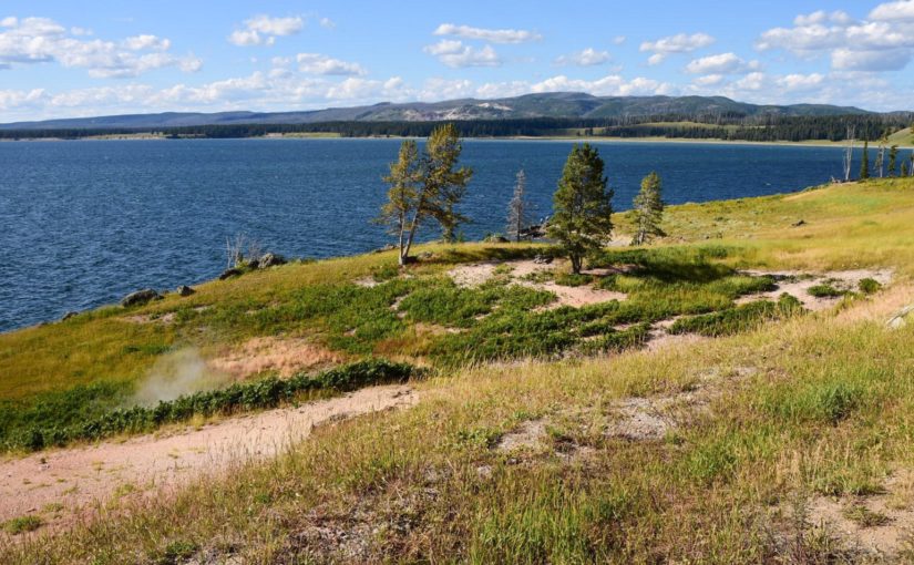
We stopped along the way at the Lake Butte Overlook, several hundred feet above the shores of Lake Yellowstone. We got an awesome view of an afternoon thunderstorm making its way down mountains on the opposite side of the lake. The area all around has obviously been burned out by a forest fire in the last few years. It felt like a worthy place to first set foot in Yellowstone National Park. After a few moments to look out and around and shoot some panoramas, we headed back down to the East Entrance Road. The road runs right below the overlook and along beaches on the lake’s north shore before coming into Fishing Bridge. We had some rain down along the beaches just before we caught the Grand Loop Road north to Canyon Village.
360-degree panoramas of the Lake Butte Overlook in Yellowstone National Park. Click and drag to look around & click the arrows to see a different location. Click the top right button to go full-screen.
Traffic Was a Real Bear

Who knew a few animals could cause such a stir?

I was able to fill the frame with this bison, it was so close to the road.
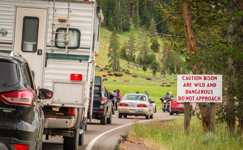
Along the road to Canyon Village, bison and elk grazed peacefully in the meadows. Motorists also sat peacefully with their cars, as we ran into our first traffic jam. So much for the park being uncongested! I knew going in that girdlock was fairly common in Yellowstone, and that it usually had nothing to do with bad driving. More often than not, traffic snarls because animals are close to the road, so massive amounts of people stop to take a look and get pictures. Sometimes the animals are on the road—and there’s no coercing a 2,000-pound wild bison to keep moving—so you just have to wait for them to cross. This traffic jam was stop and go for what seemed like miles though…so something big must have been happening!
Continue reading RealImaginaryWest Day 8 – Buttes, Sulfur & Bear Traffic in Yellowstone


