RealImaginaryWest 2019 Day 5—A Grand Geyser Tour of Yellowstone National Park

Getting Started

We both woke up for our own reasons around 5am this morning. (You can probably guess what they were.) My pad was deflated again, so I did something about that when Becky got up. Sadly for me, I was too warm in the cold, and sweat so much that I think it saved me an earlier trip to the restroom. Sadly for Becky, she did not stay comfortably warm despite her best efforts. Becky tried to catch some more Zs while I tried to catch up on my writing since I knew it was unlikely I’d fall asleep again.

Norris Geyser Basin

At 6am we were both awake and I asked Becky if she was up for getting out early to beat the crowds. She said OK, so by 6:30 we were on our way to Norris Geyser Basin. The entire drive was foggy and mysterious, mainly because of the cold morning air and all of the hot steamy water in the park. We couldn’t see very far ahead of us in Gibbon Meadows and the entire Norris area was shrouded in fog.

Norris Geyser Basin is one of the most popular attractions in the park, and it has extremely limited parking (as do most things in Yellowstone). We definitely made the right move coming early, since we snagged the very closest parking space to the trail into the geysers while the lot was still mostly empty.

Steamboat Geyser

My first thought when we arrived was to check on Steamboat Geyser, the park’s and the world’s most powerful, topping over 350 feet during major eruptions that can last for days. Norris is almost a full thousand feet higher in elevation, so there was ice on the boardwalk leading to Steamboat. I hadn’t considered what this actually meant until we got close enough to the geyser to hear it bellowing water and steam! Sure enough, Steamboat began a major eruption at 10:23pm last night that was still going on this morning!!! People who stayed at Norris Campground a mile away last night said they could hear it when it blew! Even though it wasn’t hitting 300 feet when we saw it, it was still pushing water up exceptionally high and in exceptional volume. What a treat!

A large geyser erupting with hot water and huge plume of steam.
Yellowstone National Park’s Steamboat Geyser, the world’s largest, during a major eruption that began the night before.
A huge plume of steam rises from a geyser.
Steamboat bellows an enormous amount of steam during a major eruption.

Continue reading RealImaginaryWest 2019 Day 5—A Grand Geyser Tour of Yellowstone National Park

RealImaginaryWest 2019 Day 4—Our Return to Yellowstone

Waking In Wyoming

Bridgegate

Last night was not my best sleep. The white noise from the river running was wonderful when I was awake, but too loud and too much like howling wind, so I woke up after only short bursts of slumber. I wish I’d put in my earplugs, I think they would have helped. To top it off, my pad deflated, which just made the bad situation with my back worse.

While the humidity was not much indication, this was our first night at altitude, as Ayres Natural Bridge sits at about 5,000 feet. Usually it’s pretty dry here, but the forecast dew point was actually close to our overnight low. Thankfully, though, dew wasn’t too bad a problem as our tent was dry on top. Since we’re now rather high, it’s time for the peeing to begin, as we have to drink ample water to stay hydrated.

So now you know what motivated me to get up at 6am. After this, I thought about the park gate—didn’t it say they lock the gate between certain hours? Sure enough, the checkin slip says the gate is *locked* from 8pm to 8am—and my notes indicated we needed to leave by 7am! So does that mean we’re stuck here until 8??? Since I didn’t feel a bit like trying to get more sleep and I didn’t know if I should wake Becky up, I needed to investi-gate!

Investi-gate

I didn’t want to leave Becky without the car or wake her up, so I decided just to hoof my way to the gate and determine the situation before proceeding. I guess my attempts to get into better shape before we left paid off, since I had hardly any trouble at all hiking the 1/2 mile or so uphill at 5,000 feet to the gate. Turns out it’s electric, and a car parked in front will trigger it—so we can leave anytime we want—fantastic! Now to go get back to Becky and start packing up camp.

By the way it was a beautiful morning, even though a bit overcast. The clouds and the colored light of the rising sun really made the mountain in the distance to the Southeast look dramatic! My hike also caused me to cross paths with several creatures, including a big black beetle and several rabbits.

Breaking Camp

By the time I returned, Becky was already astir and ready to help break camp. We got everything put together by 7am, but I had to take advantage of the much brighter light to get some photos and video before we left…which didn’t happen until about 7:20 or so.

Pit Stop In Casper

We stopped just inside Casper for gas, mostly so I could clean the windshield and of course, pee again. I really picked the wrong gas station though…an older gentleman stood outside the restroom…and there was a handwritten “OUT OF ORDER” sign on the men’s room door. He sheepishly went into the women’s room, and then came out saying something about the flapper on the toilet…oh man. I walk in, see the cover off of the toilet tank and decide I’ll figure it out, and tried to close the door. Seriously??? The door was not properly hung, so I couldn’t close it! I didn’t have the time to monkey with it, so I closed it as much as possible and hoped for the best. I did have to make sure the flapper in the tank didn’t get hung up on the lever pulling it open, but otherwise everything went fine after that.

I ran back outside to work on the windshield and apologized to Becky for picking the worst possible gas station. I guess it was clean…but they really need a handyman to get things in proper order. Becky came back a couple of country songs later (the pickup truck song really got me working faster) and we got back on the road.

A New Route To Yellowstone (For Us)

Now the usual road to Yellowstone for a lot of people from the East is to cross South Dakota and most of Wyoming on I-90, and then to take either US-16 from Buffalo or US-14 from Rochester. We did that route with US-16 on our first trip back in 2015, passing through Ten Sleep Canyon and Cody. Since we were coming through Casper farther south this time, we would continue to follow US-20 and pass through Cody again. This would give us an opportunity to see some new parts of Wyoming.

I-25 between Douglas and Casper mostly follows the North Platte River, with mountains off in the distance, mostly to the south. After we diverged to stay on US-20, the road basically passes through barren lands without much of a view of anything but grass, sagebrush, and an occasional oil or gas well until you get to Shoshoni.

Hells Half Acre

Our first stop, Hells Half Acre, breaks up this drive. This rugged canyon actually sprawls 320 acres, and appears to have at some point had a building there, but all that’s left now is the foundation.

A multilayered jagged rock wall in a canyon with mountains in the distance against a blue sky
Hells Half Acre on US-20/26 west of Casper, Wyoming

Continue reading RealImaginaryWest 2019 Day 4—Our Return to Yellowstone

RealImaginaryWest 2019 Day 3—Nebraska’s Bridges To Buttes Highway & Beyond

Waking Up On the Niobrara

Turning In By Moonlight

I forgot to mention in last night’s post that I finished packing up by moonlight. The campground at Smith Falls so far as I could tell lacked artificial lighting, so my eyes were able to adjust very well. It’s incredible that a 3/4-full moon could light the night up so well, and for the most part we modern humans have no idea how well our eyes adjust to it because of all the artificial light we surround ourselves with. The funny thing about it is that orange or yellow light from a fire doesn’t prevent your eyes adjusting to the moonlight. Had it not been for me sitting there in just firelight, I don’t think I would have realized how bright the moonlight was.

Getting Started

Anyway, I think I may have actually slept reasonably last night. And my mattress stayed inflated all night too! On last year’s trip I realized it was losing air when we camped at Yosemite. I found a tiny little hole on the bottom and patched it up earlier this season. After two weekend camping trips since, I wondered if a leak might still be present because it seemed to still lose air, albeit more slowly. Perhaps that was not the case.

I stirred around 5:30am, about an hour before sunrise. The moon was gone but the sun had alrighty begun to intrude with first light. The entire campground was quiet with the exception of the tranquil flow of the Niobrara River.

Becky awoke around 6:15. We witnessed some brilliant red colors this morning—I should have thought about that saying, “Red sky in morning, roadtripper take warning,” or something like that. We certainly ran into some weather today…but I get ahead of myself.

What’s With the Humidity?

The first weather we noticed last night was the humidity. Smith Falls State Park is just west of the 100th Meridian, which is about where the altitude of the Great Plains increases and in turn the climate becomes more arid. In general, you can grow crops without relying heavily on irrigation east of the 100th Meridian, but not west of it. We’ve noticed in years past that the air is generally much dryer overall than it was tonight. It felt positively clammy well before sunset—more like an Ohio summer.

When we woke up this morning, our tent was soaked from the dew. We’d left the rainfly open last night to get airflow since it was rather warm. I made the mistake of leaving my sandals out in the open and they were terribly wet. Once we bit the bullet and got down to business, we made short work of packing the bedding and tent, leaving the campground around 7:30am.

Real Food For Breakfast!

Our original plan included a full day of stops at a few more places in Nebraska before heading into Wyoming for the night. One of these was Toadstool Geological Park, which sounded wonderful, but required a 13-mile drive down a gravel road. Maybe we’ll try that in the future during a more normal dry year when the road is less likely to be flood damaged like we saw in the campground in Smith Falls State Park.

Since we’d dropped Toadstool, that freed up plenty of time for us to get real food for breakfast! We headed into Valentine and ate a full breakfast at the Bunkhouse Restaurant in the center of town. The service was great, and the food was good diner fare that hit the spot for us.

The Bryan Bridge

After breakfast we headed south of town a mile or two to check out the Bryan Bridge, which used to carry US-20 across the Niobrara River. On the opposite side of the new US-20 bridge sits an old railroad trestle that now carries bicycles instead of trains.

The entire area around Valentine has incredibly beautiful terrain! The hills around town are lovely, and the Niobrara River seems like a wonderfully quiet place to canoe or kayak through them.

Northwest Nebraska

Not far west of Valentine, the terrain becomes less rugged with more rolling hills and fewer trees. The aridity west of the 100th Meridian certainly becomes apparent. We drove about two hours through another handful of very quiet tiny little towns.

As we approached Chadron the terrain changes again. Along with rolling hills, rocky buttes began to impose themselves on the horizon. Chadron was a bit larger than Valentine and even had Walmart. Here we turned south to visit Chadron State Park.

Chadron State Park

The buttes only became bigger and more concentrated as we approached the park. This area reminds me very much of the drive between the Badlands and Black Hills on Highway 44 in South Dakota and Wyoming. We pulled into the park office, paid the $8 out-of-state day-use fee, and headed up the park’s scenic drive.

I wanted to see the Blackhills Scenic Overlook, but the narrow high-crested gravel road made us rethink this. We instead continued on the scenic drive past a picnic shelter with a nice retro playground near the horse pasture. We didn’t stay long here since we hoped to get to our campground for the night a bit earlier than originally planned, and we still had one more stop…

Horses graze in light-green grass meadow with grass-covered peaks in the background. Evergreen trees dot the meadow and the peaks.
Horses grazing in a pasture at Chadron State Park in Northwest Nebraska

Continue reading RealImaginaryWest 2019 Day 3—Nebraska’s Bridges To Buttes Highway & Beyond

RealImaginaryWest Day 13 – Grand Teton National Park to Craig, Colorado

After a boat ride and a short hike up to Inspiration Point at Jenny Lake, we depart Grand Teton National Park and Wyoming for Craig, Colorado. This takes us most of the way to Rocky Mountain National Park, where we head tomorrow.

Waking Up

After a few days at altitude slowly dehydrating me and making me feel like garbage each morning, waking up today was really easy. First light came, and my bladder reminded me of how much water I’d been drinking to rehydrate after yesterday’s visit to the hospital in Jackson. My bladder woke me up around 1:30am too. Oh the price we pay to stay healthy while roughing it…

More Wet

Once I’d returned from the restroom and was able to consider less urgent matters, I noticed our tent was covered with water droplets. I complained to Becky about how wet everything was still…and she informed me that it had rained again overnight. Grrr!!! That explains it! (I must have slept better than I thought!)

Since we had to pack up this morning, this was disappointing. It became downright frustrating when I realized that water was inside the tent again too, and that all of our damp towels left out to dry overnight were now quite soaked instead. I did not expect rain to be this much of a problem out West where summers (I thought) were mostly dry.

Most of all I was beyond irritated with our tent. Every time it rained, water got inside. I really expect any tent I own to do two major things: 1.) keep me warm, which this tent was not great at, and 2.) keep me dry…major fail. I came to find out later that you’re supposed to seal these things at least once a year. (You’d think they’d put that in the setup instructions!) And maybe it’s unrealistic on my part to expect a three-season tent to be all that warm.

Anyway, expectations aside, our Coleman Rosewood 4-person tent is a great starter tent. But this road trip did expose some weaknesses. It didn’t ventilate exceptionally well in the heat, but it also didn’t hold onto heat overnight. Also, the poles are made of fiberglass, and break easily even under extraordinary care—they’re also not easy or even possible to repair, and replacements cost almost as much as the tent. It also has a high profile which gets flattened by strong winds like we experienced in De Smet, South Dakota. Maybe we’ll look into an upgrade for next year…

So with a soaked tent and soaked towels, packing up was going to be a drag. I picked up the driest towel I could find and started wiping. I still saw water droplets. Our entire rainfly was also wet on the inside…condensation from our breath in the cold air. We could probably pack everything up now and dry it off in Craig, but I wasn’t fond of having a damp tent in the car all day long. Tonight’s rain potential had also inched up from 0% to 10%. Awesome. Ten percent seems to be all it takes this summer.

The best course of action seemed to be to leave the tent up to dry here for a few hours. This meant an extra hour of driving from Colter Bay to Jenny Lake and back from our hike, and tacking on an extra 30 minutes to our drive down to Craig. And checkout time is at 11am. Bummer.

Off to Jenny Lake

By around 7am we had everything but the tent packed up, and we were on our way to Jenny Lake for one last hike before leaving Grand Teton National Park. Yesterday the plan was to take the shuttle boat across and hike up into Cascade Canyon. Since we had a 6-7-hour drive ahead of us, we’d do an abbreviated version of that this morning. The shuttles run 10 minutes apart, so I guessed it must take just under 10 minutes to cross the lake. With a 30 minute drive back to Colter Bay and another 30 minutes to dry off and pack up our tent, I estimated that we needed to be on a boat back a little before 10 o’clock. This would give us about two hours to hike—not a ton of time, but hopefully enough!

Along the way, I saw a sign for North Jenny Lake and a scenic drive. I remembered seeing this one-way road along the lakeshore on the map. Being impulsive and curious, I decided to check it out. It was a pretty little drive with a few pullouts and OK views along the lake, but it wasn’t anything seriously impressive like I’d hoped. My mind was wandering anyway…I kept thinking about whether we shouldn’t see about a late checkout to give us a little more time on the trails.

The light was beautiful, so I couldn’t pass up a quick stop at Willow Flats Overlook to capture a high-resolution panorama. This can be printed HUGE, since the original is 24817 pixels x 8272 pixels. The low-hanging clouds looked so cool!

I also grabbed this shot with a clearer view of Grand Teton.

This ground squirrel foraged around the fringes of the parking lot at the Willow Flats Overlook.

Parking at the Jenny Lake Visitor Center was a breeze when we arrived at 7:50! Coming in yesterday just before 11am put us at the peak of the crowds. Of course, it was time for me to hit the restroom again. Becky also wanted to comb the gift shop one more time to find a “Jenny Lake” souvenir for her best friend, Jenny, back home. This would easily take us up to 8 o’clock, which is when the camp office at Colter Bay opens. Before we get on the shuttle and leave cellular range, I could call and ask for a late checkout.

Unfortunately, Becky came up empty again. They only had stickers and fridge magnets, and everything else had sold out. We did, however, get OKed for a noon checkout! Awesome! Now we’ll definitely have time for a good hike.

Taking the Shuttle Boat

Round-trip fare for the shuttle boat across Jenny Lake was $15 per person. This seemed pretty steep for a short trip, but when you figure in the remoteness and the short four-month tourist season here, it’s more understandable. It would definitely save us time, too, as it shaved a six-mile hike to Inspiration Point or Hidden Falls down to only two miles round-trip. What really sweetened the deal was that they also sold Jenny Lake water bottles at the docks—so we had more water, and Becky finally had the gift she wanted for her bestie!

A shuttle boat head back to the docks by Jenny Lake Visitor Center.

Becky enjoys the ride across Jenny Lake in the crisp morning air.

The lake was very calm. Winds here seemed to be calm overnight and intensify with the sun throughout the day. Becky said she heard that Jenny Lake is hundreds of feet deep, which would keep the lake from getting too rough for very long. This made for a smooth ride across. The overnight storm had also left behind some beautiful low clouds between us and Mt. Moran.

I was a little torn between hiking to Inspiration Point or Hidden Falls. The driver taking us across shared that Hidden Falls was an easier trail but had no view, while Inspiration Point has an elevation change of 600 feet over the course of a mile and an extraordinary view at the end. We probably could have done both, but the trail in between was closed.

I asked the driver how long it took to get to Inspiration Point, and he way very vague. It was pretty difficult to judge someone’s physical condition and acclimation to the altitude. He said it takes him about 30 minutes, and that most people should expect it to take at least 45 minutes. This sounded like it would work for our timeframe, which at this point was a little over 2 hours.

Continue reading RealImaginaryWest Day 13 – Grand Teton National Park to Craig, Colorado

RealImaginaryWest Day 12 – Too High & Too Dry at Grand Teton National Park

A late start put us in a bind for parking at the Jenny Lake Visitor Center. We were not here long, however, and we did not get to go hiking—but that had nothing to do with parking. Rather, we spent most of the day in Jackson after a visit to St. John’s Medical Center. We returned briefly to Jenny Lake late in the afternoon before heading back to Colter Bay Village. (Ignore the map for now…Google Maps is being dumb 😛 )

Travel Is a Learning Experience

Yes, folks, they say experience is the best teacher. On certain days of this trip, we’ve definitely had an experience that taught us something we’ll never forget. Back in South Dakota, we learned that it’s really nice to have a contingency plan if a thunderstorm rolls through when we’re camping on the Great Plains. Just a couple of days ago, I learned that my lack of planning can easily result in an overtired and unhappy Becky. And this morning, I learned something about spending time at altitude that I will never ever forget. I suppose the “they” who said that experience is the best teacher could also say that travel is the best way to gain experience.

Today’s lesson culminated this afternoon. I say culminated, because the lesson had actually started way back when we arrived in Yellowstone—I just didn’t know. Remember those headaches I’d mentioned over the last two days or so? Yeah, well I went to sleep last night with one, and it was still lingering when I woke up this morning. I’ll explain the connection in a bit…

Slow Start

Yesterday we left Yellowstone National Park and set up camp in Colter Bay Campground in Grand Teton National Park. It was a smooth and uneventful day beyond a little sightseeing. We spent most of the day relaxing and just setting up camp for the next couple of days. We even got to bed at a good time, about 10pm. Aside from the headache I went to bed with, I felt pretty good, and just chalked it up to our altitude at 6,800 feet. Becky too wasn’t feeling 100% herself. Either way, I thought a good night’s sleep would have us feeling better this morning, and we’d get an early start.

Well, we didn’t. I could have felt better, but I felt mostly OK. Becky wasn’t feeling all that great. So rather than arriving bright and early at Jenny Lake to take a shuttle boat across to hike Cascade Canyon, we slept in. This sounds nicer than it felt, since our air mattress was almost completely flat. Becky suspected a slow leak, but I thought tired batteries could also be the culprit. I think we finally got on the road around 10am.

The views of the Tetons along the way were incredible! The morning sun lit Mount Moran and Grand Teton in a totally spectacular and yet totally different way than we saw near dusk the night before. At this point I was totally engaged in the scenery and my photography, as usual…and my morning meh feeling was no longer on my mind.

Mt. Moran as we passed the Willow Flats Overlook, where we stopped last night on the way to Signal Mountain

Grand Teton dominating over the Teton Park Road and the Potholes Turnout

Arriving at Jenny Lake…Sort Of

We arrived at the parking area near the Jenny Lake Visitor Center and the place was completely packed. I knew this was a popular area, but I had no idea how much demand exceeded supply. As Becky drove around the parking lot hunting for a space, I began feeling more and more woozy. I’m sure winding around wasn’t helping, but my heart was starting to beat faster now too. After we passed Willow Flats I noticed I felt a little short of breath and used my albuterol inhaler which helps with my asthma. That can raise my heartbeat, but not usually this much. Things did not feel right and seemed to be getting worse. I told Becky that she had to stop the car. Since there were no parking spaces anywhere in sight, she was a little confused. I told her to just stop somewhere that cars could still pass, because I felt terrible and needed to stop moving.

Continue reading RealImaginaryWest Day 12 – Too High & Too Dry at Grand Teton National Park

RealImaginaryWest Day 11 – Old Faithful & Moving to Grand Teton National Park

Old Faithful was the last sight we saw in Yellowstone before we packed up at Grant Village and moved on to Grand Teton National Park. After we scored a campsite, we relaxed along the shore of Jackson Lake and had dinner. Our nightcap was a short drive up to the summit of Signal Mountain.

Waking Up to Rain… Lovely

After spending a lot of time cleaning and drying off our tent when we packed up at Canyon Village the day before, I woke up at 5am this morning in Grant Village to the sound of rain on our tent.

I was already plenty anxious about getting an early start and moving down to Grand Teton National Park today. I was especially nervous about moving because all of the campgrounds at Teton are first-come, first-served so we had no reservation. I wanted to be completely packed, go see Old Faithful, and then beeline directly to our next campground as early as possible. Having to dry a wet tent all over again could jeopardize getting our next campsite. Boy was I annoyed.

As the rain continued to fall and I continued to stew, I expressed my irritation to Becky. She told me that all that negative energy and anxiety did absolutely nothing to help us, and that it robbed me of enjoying things. “Roll with the punches,” she said. I realized she was absolutely right.

So even though the rain hadn’t stopped, I took my wife’s sage words to heart—I stopped stewing and started thinking. I suggested that we get up right now, go see Old Faithful erupt, and then hopefully come back after the rain to a dryer tent to pack up.

Becky dug the idea so we got up at about the same time the rain stopped. We shuffled off to the restrooms and got on the road at about 6:30am for the 35-minute drive to Old Faithful.

Old Faithful

The Grand Loop Road passes below the overpass for the Old Faithful Road.

Old Faithful steamed quietly when we arrived.

People begin to disperse after an eruption with the historic Old Faithful Inn as a the backdrop.

Old Faithful is by far the most famous and most popular attraction in Yellowstone National Park. The otherwise two-lane Grand Loop Road actually widens to four lanes with a freeway-style trumpet interchange that takes you into Old Faithful Village. It’s so strange to see such urban infrastructure inside such a wild and vast national park, but it makes sense to keep traffic moving in order to minimize air pollution in this pristine place.

Besides the geyser, Old Faithful Village itself is quite extensive. There are a few stores, restaurants, and lodges here, including the historic Old Faithful Inn. The visitor center sits only one or two hundred yards from the geyser everyone wants to see. We arrived here at about 7am and checked for the next predicted eruption time. Unfortunately, the visitor center doesn’t open until 8am, and the time posted in the window was from just after close the night before.

So we were here, but we had no idea when the next eruption would be…but I didn’t panic, since there weren’t any people gathered as if it was about to blow. Finally, I found a sign that said I could find geyser eruption predictions at @GeyserNPS on Twitter. I pulled out my phone and hoped for good cell service… Huzzah! The feed predicted the next eruption at 8:12am, plus or minus ten minutes. I also found out I could call a number for other geyser predictions.

To say that Yellowstone has geysers is an understatement. When we drove around the park yesterday, we realized that there are not just a few geysers, but that there are a few geyser basins that each have several geysers! Old Faithful is only one of many steaming holes in the ground that erupt hot water every so often in what is called the Upper Geyser Basin. So since we had plenty of time before we needed to stake out a particular spot, I called the prediction number to find out if any other geysers were expected to erupt nearby. It turned out that Daisy Geyser may be a possibility, so I made sure we picked a vantage point where we could see both in case they went off at the same time—how cool would that be!

A fun fact about Old Faithful is that it is not the largest, tallest, or hottest geyser. It is, however, the most dependable big tall geyser in the park. It has been erupting about every 90 minutes for years, with varying heights of a few dozen feet to 200 feet. While you can’t quite set your watch to it, its dependable vertical spectacle is how Old Faithful earned its name and its spot as the top attraction in the park.

Old Faithful at its peak during eruption at 8:05am on July 12, 2015

Old Faithful erupted for us right on time at 8:05am. I’d read that Old Faithful often “plays” a bit with smaller eruptions, but there was no play involved here. About a minute or two before water burst forth, the geyser bellowed much more steam. The water pushed higher and higher, and then stayed at peak height for about a minute and slowly died down into a tiny fountain. Finally the water stopped and the geyser returned to just a steaming hole in the ground.

We didn’t see Daisy erupt, but Old Faithful was very cool all by itself. It was time to get back to pack up camp and move on in time to get a campsite in Grand Teton. My first choice of campground was Jenny Lake, which was a good two hours away. I knew that was a longshot, but my backup campground at Colter Bay wasn’t much closer, and I was nervous both could fill by noon.

Continue reading RealImaginaryWest Day 11 – Old Faithful & Moving to Grand Teton National Park

RealImaginaryWest Day 10 – Grand Canyons, Geysers & Grant Village in Yellowstone

After packing up camp at Canyon Campground, we hiked to the brinks of Lower and Upper Yellowstone Falls and had a late lunch at the Canyon Lodge Dining Room. We then took a drive to Norris via Virginia Cascades and drove the southwestern section of the Grand Loop Road on our way back toward our new campsite in Grant Village.

Sleeping In (Sort Of)

Even though I didn’t get to sleep until midnight last night, I still woke up at dawn, this time with a headache. I get those sometimes, mainly from muscles in my back and neck being messed up by car accidents and too much sitting for work. Usually I apply pressure in the right places and my headache subsides, but today that wasn’t working for some reason…so I just took it slow and endured the pain.

I looked over at Becky, still sleeping. Yesterday we got up at 5:30am, but I had kept us go-go-going so much that we got to bed too late to do it again today. Becky needed recovery time, and I was glad to see her getting it. She and I were both up and about around 8am. I started a fire so we could have a real breakfast and so Becky could make some real coffee. I also took the opportunity to set up my pano rig so I could get a 360 shot of our campsite.

This was just not our morning though. The late morning lighting conditions weren’t working for me, and I kept forgetting steps in creating my 360 shot. Becky’s campfire coffee percolator got too hot on the fire and the handle melted. Our frustrations were getting the better of us. My headache still lingered. We still had a lot of packing to do. And I still hadn’t talked with Becky about how to avoid a repeat of yesterday’s Yellowstone Mania. All this anxiety got us super grumpy, but things were good once we let each other chill out for a few minutes. Once we really got to packing, the day got steadily better.

360-degree panorama of Site J193 at Canyon Campground in Yellowstone National Park. Despite my frustrations, this actually turned out well! Click and drag to look around & click the arrows to see a different location. Click the top right button to go full-screen.

Packing Up at Canyon Campground

This pack-up was messier than the last one though. It had rained quite a bit while we were out yesterday. We got some water inside our tent, but by now everything was dry. The outside, however, was still wet in spots and the tarp underneath was completely wet with tree debris stuck all over it.

This is where I’d like to leave an endorsement for a $2.07 hand broom and dustpan set I bought over 15 years ago when I moved into my first apartment. It wasn’t great for sweeping my kitchen floor back then, but it works perfectly for so many things when you’re camping! Every time we pack up the tent, I use it to sweep all the fuzz and debris on the floor. I use it to brush off all the bugs, needles, and leaves on the outside of the tent. I can even use the brush to help my tent dry faster by spreading out the water beads.

Unfortunately for my trusty dustpan, I overestimated its abilities. When we arrived, I used it to shovel ashes out of the center of our fire ring and it worked great. I actually made a pile of them next to the ring so I could use them if I needed to put out a fire. Unlike back East, it’s very dry throughout much of the West, making everything from the grass to the brush to the trees quite flammable. As a result, campers are instructed to extinguish all fires before they leave their site or go to sleep for the night, either by dousing with water or covering with dirt. After cleaning out the tent, I thought that I better shovel those dry ashes from our first night onto the fire to put it out. Easy peazy, right?

Well, the rain had soaked my dusty ash pile and turned it into something more like hard clay. I didn’t expect this, and so I dug in hard and shattered my faithful dustpan. 🙁 I was so angry! I still needed this thing for the rest of our trip, and now it was broken. Becky doused the fire with water after this fail, leaving a pool of boiling water but no smoldering ashes behind.

OK, so maybe it was actually after we put the fire out that the day really started to improve. One of the last things we packed up was our tent and tarp. As I folded each part of the tent, I used the hand broom to clear off the tree junk and a towel to wipe it dry. For the last little bit, Becky just held the tent up for me while I brushed and dried it. After the tent was neatly in its bag, I swept off the picnic table at the vacant campsite next to us and draped our tarp over it so I could brush off one side. I then folded it in half to brush debris off of the other side and off the table again. Then I flipped the tarp and cleaned the other side. Finally, I had a relatively clean, dry tarp to fold and put into its bag.

So on a big or a little trip, never underestimate the usefulness of a good hand broom and dustpan!

Back to Yellowstone Falls

Ravens were a common site anywhere they could find scraps…either from humans or other animals in the park.

Now that our campsite was packed into the car, we drove out to the main road and back over to the parking area near the brink of Lower Yellowstone Falls. It was a late start for us, arriving about noon. I wanted to hike in and see more of the canyon, including the Upper Falls. I popped open the trunk and began rummaging through my photo bag, thinking of which pano head and lens to bring.

That’s when I remembered the day before and said to myself, “Screw it! I’m tired, and I need to just relax and have some fun, and stop trying to be a documentarian for every hour of the trip.” I decided I’d bring my camera and only my 24-70mm lens, which is plenty versatile and won’t get me too hung up shooting panos.

I informed Becky of my decision. She smiled and replied, “I like ‘Screw It’ Day!”

She thought it was cool for me to grab a camera and shoot stuff, but that the day be more about us and less about the ‘photo shoot’. I liked the sound of it too.

A Bug’s Life

Before we got going, Becky made preparations sitting in the passenger seat of our car with the door wide open. While she was looking down intently, I saw this big black bug with giant antennas land on the dashboard almost directly in front of her! In a hopefully unstartling tone I told her, “You might want to look up, there’s a big black bug in front of you.” She sorta freaked out and slowly backed out of the car. I was in no position to reach it. It stayed where it landed for the most part. Becky grabbed a map and tried to scoop it away, but it crawled deeper into the car! It stopped in a little nook on the side of the center console, but it was dangerously close to crevices where it could hide behind the dashboard. This required a better approach, or this thing was going to die somewhere back there and possibly stink up the car (glad it wasn’t ours).

Becky acted fast and cut the top off a big empty water jug we hadn’t yet thrown out. She then easily scooped him up and let him go outside of the car. We kept the scoop in case we needed it again. The bottom of the jug fit a loaf of bread perfectly, so we used it to protect our bread from getting smashed in the back. So I suppose you could say she killed two bugs with one jug!

Brink of the Lower Falls

People gathering to look down from the brink of Lower Yellowstone Falls

It’s a 600-foot drop but less than a half-mile hike to get to the top of Lower Yellowstone Falls. This area was far more congested than anywhere else we’d hiked so far. We could definitely tell this was like the Disney World of national parks with the casual manner in which several people took the paved trail. I had three people nearly collide with me on the switchback down, and Becky just missed getting hit in the face with a selfie stick.

In spite of the number of people and the rudeness of a few of them, the top of the falls was incredible! It’s amazing how fast the water moves through the upper canyon toward the Lower Falls. The sound of the water was just enormous. And the view of the canyon with a partly cloudy blue sky above was just awesome and unforgettable!

The Grand Canyon of the Yellowstone River from the brink of the Lower Falls

Continue reading RealImaginaryWest Day 10 – Grand Canyons, Geysers & Grant Village in Yellowstone

RealImaginaryWest Day 9 – Hot Springs, Overlooks & Oversights in Yellowstone

Our first full day in Yellowstone took us to Tower Fall in the morning and Mammoth Hot Springs at midday. We grabbed lunch outside the park in Gardiner, Montana, then found some wood and a moose on our way back to Canyon Village. We closed out the day at the Grand Canyon of the Yellowstone River and ate a late dinner back at camp.

Our First Full Day

Has a full week already past? Are we only on Day 9? Just yesterday I told Becky that 1 week and 2 hours ago (because of the time change) we left! It also doesn’t seem possible that today was Friday and that we still have more than a week to go…wow…we planned all this??? I don’t know how we did it, but I know we could only have been this successful from working together! I know I couldn’t have done this as well without Becky!

Today’s entry starts with the end. Right now I’m sitting at a biggole fire that took longer than I hoped to build, but I’m feeling content that I am warm, our tent is still good, we haven’t run out of money, and we are doing OK. It’s been tough sometimes and we’ve gotten in each other’s hair occasionally, but we have really enjoyed ourselves over the last week. We’ve learned a lot, and we’ve gotten to see a lot of the country!

I feel like we’ve done really well so far, but today I know my “OMG Yellowstone!” mania pushed Becky way too far. We were up at first light this morning in time for sunrise. We were out before the tourists wake up to clog all the roads and scare away all the animals. And then we ran almost all day without much downtime. It’s almost midnight now, and we still aren’t quite in bed. The original plan for tomorrow was to start early like we did today, but I know I ran Becky ragged, so I doubt it will work out that way.

Enduring the Cold

Let’s rewind and go back to how last night went. Becky was super cold, and had to cover her face with the top in-between blanket. It was by far the coldest night we’ve ever slept in. We’re up around 7,900 feet in elevation here at Canyon Campground, which means the atmosphere is much thinner and the temperature in turn stays much colder—often only in the 60s for a high and down into the 30s at night, even in July. By contrast Mammoth Campground, near the park’s North Entrance, sits at about 6,200 feet and experiences temperatures that are roughly 10 degrees warmer. I was concerned about whether we’d get rain or wind on top of the cold at night, but thankfully the winds calmed after dark and it only rained during the day.

Layers are key to beating the cold. Becky and I both wore at least 2-3 layers up top, and I had two on the bottom. We had two blankets between our sleeping bags and our air mattress to insulate us below, and then another one inside the sleeping bags to keep us warm on top. Without the extra blankets, we would have been unbearably chilly! But as it was, everything was rather comfortable for me, so long as I kept my hoodie up to keep my ears warm.

Yellowstone Mania

Steam rises from Wabash Hot Springs at sunrise.

Tower Fall

The Yellowstone River as it passes out of its grand canyon

Now I wanted to be up early enough to get some photos of sunrise at Yellowstone Falls, which is very close to our campground. Becky agreed that she’d get up at 5:30am and we’d be ready to go at 5:45. We got going right on time. The weather was definitely brisk, but the mostly cloudy sky looked to make for interesting images so long as the clouds didn’t completely block out the sun. After shooting the falls, we planned to go back to camp to shower up, then hit Mammoth Hot Springs and come back to camp again for early dinner and maybe a nap. Later, we’d go back to Yellowstone Falls in time for sunset.

When we drove out to Yellowstone Falls, however, there was a thick blanket of fog over the entire canyon :-(. This would not do, and I wanted to take advantage of the early light, so I decided we’d upend everything we’d planned and drive an hour to Mammoth Hot Springs right away. My mania had kicked in, and it wasn’t even 6am…

A few miles down the road from Canyon Village, we stopped at the Wabash Hot Springs Overlook, since it looked like our last good opportunity to take advantage of the sunrise. As I set things up, it was awesome to watch the sun cast its first light on mountains that had to be miles and miles away.

Things were starting to warm up, but my stomach started asking for food and Becky started asking for coffee…so we stopped by the Tower General Store. It was too early for it to open, so we made use of the time and hiked the short trail to 132-foot Tower Fall.

Continue reading RealImaginaryWest Day 9 – Hot Springs, Overlooks & Oversights in Yellowstone

RealImaginaryWest Day 8 – Buttes, Sulfur & Bear Traffic in Yellowstone

After packing up at the Ponderosa Campground, we got breakfast and hung out a bit in Downtown Cody. Then we stopped by the ginormous Buffalo Bill Center of the West—which was way way bigger than we expected! Next, we drove into Yellowstone National Park, making a quick stop at the Lake Butte Overlook to watch a thunderstorm across Yellowstone Lake. Lastly, we got stuck in bear/bison traffic near the Sulphur Caldron and Hayden Valley on our way to camp at Canyon Campground. This taught us that carpe tempore is the rule when passing restrooms…or trees……

Calm Night in Cody

Today we go from roughly 5,000 feet in elevation at the Ponderosa Campground in Cody, to 7,900 feet at Canyon Village in Yellowstone National Park. Altitude tends to catch up with flatlanders like us above 7,000 feet—also the days and especially the nights are much cooler…eek!

The sun was up around 6am at the Ponderosa Campground, and so was I. We were both fairly well-rested thanks to the calmness of the night. Not only was the weather perfect, but our 60 young neighbors from Teens Westward Bound were awesome too. It was clear that this was a great group of kids! At 6:30 they received their wakeup call from the trip captain: “It’s time to get up, little darlin’s!” she repeated kindly in her North Carolina accent, walking about the camp. I got a chance to talk to her later and ask a few questions. I was especially interested in how they handled inclement weather, as De Smet a few days before was still fresh in mind. They all camped out in the open on tarps and sleeping bags, which meant even less shelter than we had in our tent.

She explained that they had about a week left on a 23-day road trip. They were headed back home to Charlotte, North Carolina through the Black Hills and Mount Rushmore, after already touring the Southwest and California. Young people are not selected willy nilly for this program—these were responsible, academically successful youths. The group from the looks was about 70% girls and 30% boys. Everyone was taught to tarp up properly so that nobody got wet or blew away. The whole purpose of the trip, besides seeing the Western United States, was teaching each and every one of them, from high school sophomore to entering college freshman, that they could do pretty much anything they set out to do!

From what I could see, that thought had sunk in. The group was two weeks from leaving home, and they each awoke without a complaint, in spite of possible homesickness, and even if some of them looked like they could have used a couple more hours asleep.

It was time for Becky and I to get started too. We got in rather late and very tired from the big day’s drive from Rapid City and the rodeo the night before. I was so tired I didn’t even get a chance to take advantage of the electricity available here to dump my camera’s memory cards and charge a few batteries. So I took care of that while we packed up the tent. We got ourselves to breakfast at around 7:30 or 8am.

A Few Hours In Cody

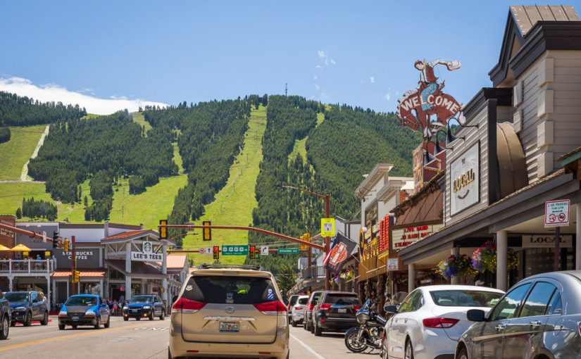
Clouds rolled over Rattlesnake Mountain toward the historic buildings of Downtown Cody early in the afternoon. Peter’s Cafe is on the right about halfway to the first traffic light at 12th Street.

Becky picked out this place in Downtown Cody called Peter’s Cafe & Bakery. All of Downtown Cody is very well put together, with plenty of historic architecture along its spacious main street, Sheridan Avenue. Peter’s was in one of the old buildings here, with a standard American breakfast menu at reasonable prices. The bacon strips were huge and everything on our plate was cooked perfectly. They had a couple of book racks with great titles for customers to read while they eat, like How to Stay Humble When You’re Smarter Than Everybody Else, The Joy of Being Broke, and the one that first caught my eye, How to Share a Bad Attitude, all by Ben Goode. Hilarious stuff! I’m gonna have to check this out more when I get home.

Before we left downtown after breakfast, I shot a couple of panoramas and Becky perused some shops. We have plenty of charming old business districts like this back in Ohio, but few are this large and vibrant—and of course none have the Western flair of Cody. I particularly liked 12th & Sheridan because of the Irma—the hotel opened by Buffalo Bill Cody himself back in 1902.

360-degree panoramas of the central business district of Cody, Wyoming. Click and drag to look around & click the arrows to see a different location. Click the top right button to go full-screen.

Buffalo Bill Center of the West

The humble South Entrance understates the magnificence and expansiveness of the Buffalo Bill Center of the West.

Before we left town, we followed a tip to check out the Buffalo Bill Center of the West. We went into the small South Entrance to pay admission, and found out that this museum is so extensive that each ticket is actually a two-day pass! We explained to the lady at the front desk, Rosalee, that not only would we not be here for two days, but we really only had two hours at most before we drove to our campground in Yellowstone National Park. She was very kind and offered for us to take a few minutes to look around without charge, in order to get a feel for all they had there so we could plan to visit on our next trip.

Let me tell you, this museum is first class, and it is huge! It is actually five museums in one. The Draper Natural History Museum explains the geology, animals, and everything else on the prairies and in the mountains of Wyoming. The Plains Indians Museum shares the history of the native tribes who inhabited the West and the effect of United States settlement. There is of course a museum about the life and legacy of the town’s namesake, Buffalo Bill Cody. They also have the Whitney Western Art Museum and the Cody Firearms Museum as well as special exhibitions. The current exhibition was a firearms loan from the Smithsonian, way back East in Washington—which felt a world away after spending a week in the West.

I’d heard the Buffalo Bill Center was a great museum, but that was an understatement! I had no idea it was on par with museums in big cities like New York or Chicago. Everything I saw here was impressive, and certainly a bargain for the price. Next time we pass through Cody, we’re certainly spending quality time here.

Before we left, I shot a couple of 360-degree panoramas outside, including the Main Entrance where the statue of Buffalo Bill stands. Afterward we re-iced the cooler and refueled to head into Yellowstone.

360-degree panoramas outside the Buffalo Bill Center of the West. Click and drag to look around & click the arrows to see a different location. Click the top right button to go full-screen.

Heading Up To Yellowstone

It was just after 1pm when we left Cody, and the weather was transitioning from morning blue skies to early afternoon storms. US-14/16/20 is designated as the Buffalo Bill Cody Scenic Byway from Cody to the East Entrance of Yellowstone National Park. Almost the entire route follows the Shoshone River through the Absaroka Mountains, passing by Buffalo Bill Dam, its giant reservoir, Buffalo Bill State Park, and eventually through the Shoshone National Forest.

Just outside Cody, the US highway enters Shoshone Canyon, snakes its way along the river, passes through three tunnels, and finally emerges just past the dam next to the Buffalo Bill Reservoir. The reservoir provides irrigation for agriculture throughout the area. It’s really gorgeous here, even on a rainy day! There are tall mountains all around with gentle brown and sagebrush prairie sloping gently upward from the lake. There were beautiful houses perched partway up the mountainsides with what I’m sure were spectacular views of the river and reservoir amid the mountains. Most land around the north side of the reservoir was part of Buffalo Bill State Park.

Beyond the reservoir, we passed into Wapiti Valley. There are plenty of guest ranches and campgrounds along the highway here that no doubt take advantage of their proximity to both Yellowstone and Cody. After a relatively straight shot from the reservoir, the valley narrows into a canyon and the road begins to wind as we enter Shoshone National Forest and the heart of the Absaroka Range. The road hugs and criss-crosses the North Fork of the Shoshone River for several miles…

Shoshone Canyon, just downstream from Buffalo Bill Dam

We got excited as we approached these two tunnels…but before we knew it, we’d already passed through more than one tunnel. When we realized another tunnel was hidden in between…we got really excited!

US-14/16/20 along the north shore of Buffalo Bill Reservoir

Driving toward the western end of Buffalo Bill Reservoir and Wapiti Valley

Just inside the Shoshone National Forest near Wapiti Wayside

And finally we saw the sign for Yellowstone National Park! At long last I had been able to achieve a nearly life-long dream to tour one of the largest, finest, most renowned parks in the world! It had taken me almost exactly 38 years to finally make the trip. Almost exactly 7 years ago I made it to my first big western national park, Yosemite, and it was positively magical! I’d hoped that Yellowstone would prove to be in its own way just as majestic, profound, and inspiring.

Entering Yellowstone National Park

The East Entrance gate at Yellowstone National Park. The entrance fee here gets you into both Yellowstone and Grand Teton National Parks. Alternatively, you can get an Annual Pass like the one we bought back at Badlands National Park that gets you into all of the parks for an entire year.

The first thing I thought about when we reached the East Entrance was that it was very quiet! I expected a lot more traffic, especially in the middle of July. Maybe everyone entered through the North Entrance from Montana or flew into Jackson and entered from the south? I was pleasantly surprised to see that the park was mostly uncongested…and I was happy to know that there was a nice little campsite waiting for us in Canyon Village.

Stone guardrails like this one on the East Entrance Road line the steep edges of most roads in Yellowstone, rather than the metal ones typically used. A park should look prettier anyway, right?

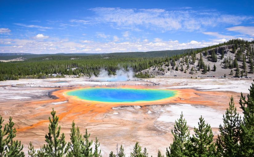
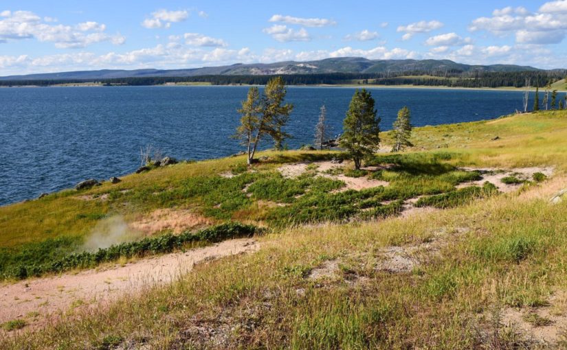
Along the way in, you pass deep into virgin mountains, with the only evidence of the hand of man being the road you’re traveling. Rather than standard metal guardrails, most roads here have stone guardrails that remind you that you’re in a national park! After emerging from the giant mountains of the Absaroka Range, the view opens up and you catch your first sight of Yellowstone Lake. The lake was much much larger than I expected it to be, and the terrain around more mountainous. I don’t know why I expected something smaller…maybe it’s because any video I’ve seen just can’t do this place justice.

The entire landscape is covered mostly with sloping grasslands and forests, with occasional rock outcroppings. This was unlike what I saw frequently in the Sierra Nevada, where bald domes and half domes of sheer granite accompanied by spires decorated the landscape like a castle or cathedral.

Just 16 miles to our campground at Canyon Village! No problem, right!?

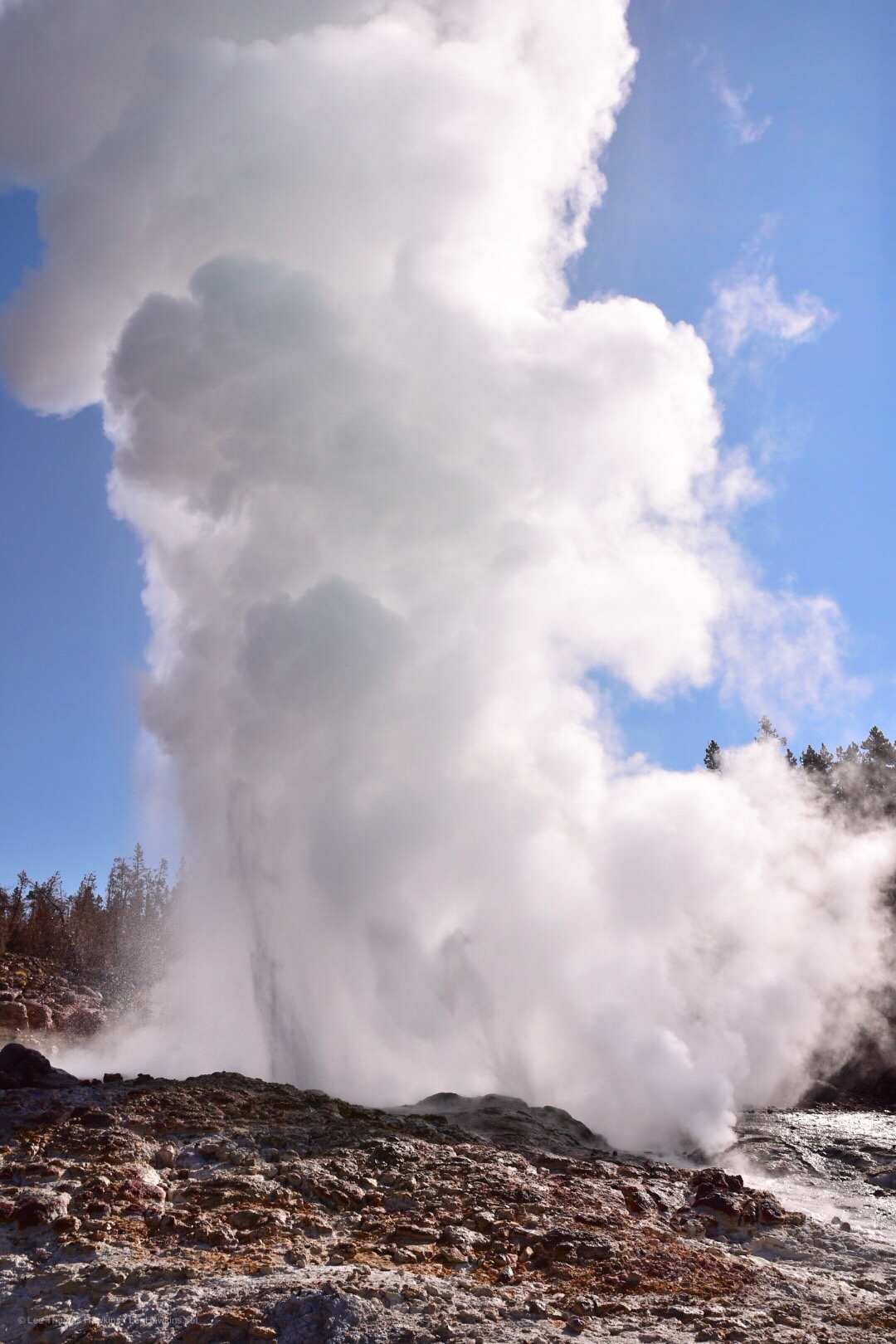
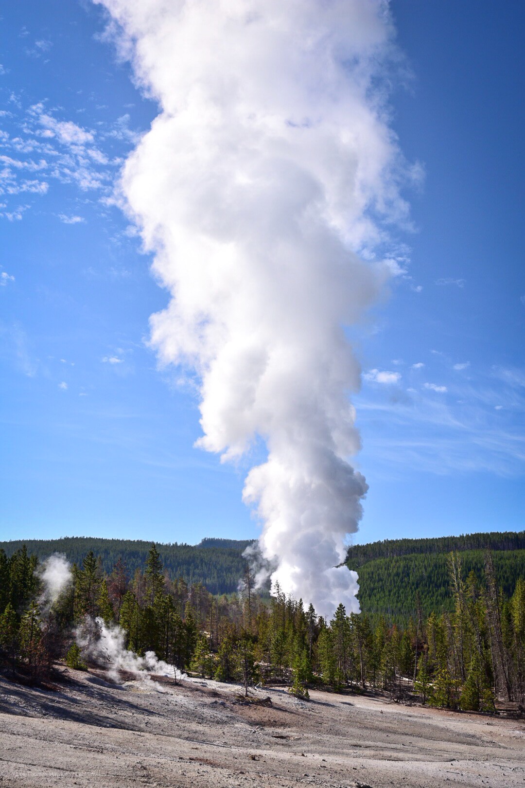
We stopped along the way at the Lake Butte Overlook, several hundred feet above the shores of Lake Yellowstone. We got an awesome view of an afternoon thunderstorm making its way down mountains on the opposite side of the lake. The area all around has obviously been burned out by a forest fire in the last few years. It felt like a worthy place to first set foot in Yellowstone National Park. After a few moments to look out and around and shoot some panoramas, we headed back down to the East Entrance Road. The road runs right below the overlook and along beaches on the lake’s north shore before coming into Fishing Bridge. We had some rain down along the beaches just before we caught the Grand Loop Road north to Canyon Village.

360-degree panoramas of the Lake Butte Overlook in Yellowstone National Park. Click and drag to look around & click the arrows to see a different location. Click the top right button to go full-screen.

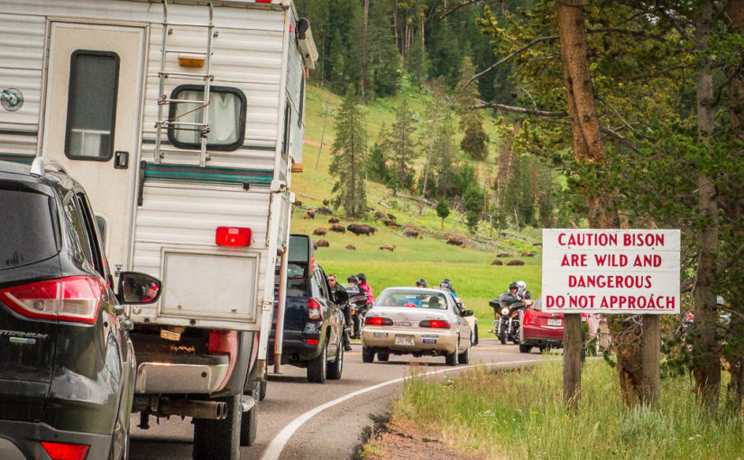
Traffic Was a Real Bear

Who knew a few animals could cause such a stir?

I was able to fill the frame with this bison, it was so close to the road.

Along the road to Canyon Village, bison and elk grazed peacefully in the meadows. Motorists also sat peacefully with their cars, as we ran into our first traffic jam. So much for the park being uncongested! I knew going in that girdlock was fairly common in Yellowstone, and that it usually had nothing to do with bad driving. More often than not, traffic snarls because animals are close to the road, so massive amounts of people stop to take a look and get pictures. Sometimes the animals are on the road—and there’s no coercing a 2,000-pound wild bison to keep moving—so you just have to wait for them to cross. This traffic jam was stop and go for what seemed like miles though…so something big must have been happening!

Continue reading RealImaginaryWest Day 8 – Buttes, Sulfur & Bear Traffic in Yellowstone

RealImaginaryWest Day 7 – Devils Tower, the Bighorns & Our First Rodeo

The most driving we’ve done since Day 1 started in Rapid City, South Dakota. We took the scenic route through the Northern Black Hills to Devils Tower. We then took I-90 to Buffalo, where we followed the Cloud Peak Skyway/US-16 over the Bighorn Mountains. We continued on US-16/20 West from Worland, through Greybull, and on into Cody…where we camped before heading into Yellowstone National Park the next day.

Devils Tower & The Northern Black Hills

We made it! This far…

Up and off we went around 7:30am from the M Star Rapid City on Mount Rushmore Road/US-16. The weather was still a bit hazy, but it was probably the clearest morning we’d had on the entire trip. We got started a little later than we’d hoped, but we figured we still had time to hit Devils Tower and make it to Cody in time to set up camp and see the famous rodeo there. After finally remembering to clean the bugs off the windshield, we followed I-90 up to US-85, and then followed SD-34 across the Wyoming state line. Here, the road turns into WYO-24 and heads to Devils Tower. We could have stayed on I-90 and taken a faster route via US-14, but these three roads were all marked scenic.

Becky and I had already decided yesterday that what we’d seen so far of the Black Hills was pure awesome! We’d love to come back and camp either in Black Hills National Forest or Custer State Park. Seeing it for a day made us want to come back for a week! However, Devils Tower and what we saw of the Northern Black Hills in Wyoming made it hard to imagine confining a return trip to only the better-known Southern Black Hills in South Dakota.

At the last second I almost decided to stick to faster highways in the interest of time. After we got a few miles into Wyoming, though, I was so glad that we took the scenic route instead of the freeway! The red rocks and canyons along the Belle Foursche River held a type of beauty we saw nowhere else in the Black Hills. It was definitely worth the extra few minutes! Then we passed over a crest and around a curve—and caught our first glimpse of something like a giant tree stump on the horizon—that was just unmistakably Devils Tower.

It wasn’t the clearest day…but this was where we first laid sight on Devils Tower from WYO-24, still over 13 miles away as the crow flies. The hills on the right are the Little Missouri Buttes, which are just 3-4 miles northwest of Devils Tower and of the same geological composition.

Red sandstone is exposed along much of the Belle Foursche River as it runs below Devils Tower.

Devils Tower as seen from the east on WYO-110. Each angle offers a unique view.

It’s no wonder the Sioux and Kiowa saw it and thought, “This means something! This is important.” (Sorry, couldn’t resist!). The Kiowa have the coolest story about what Devils Tower means. The story is told in Ken Burns’ documentary, The West, and they had a display about a similar legend.

I can’t help but feel a sadness about the cultures that were destroyed by the United States’ westward expansion. The Indians really loved the land, and all the creatures that lived in it (at least when they weren’t warring with rival tribes). While the new Americans certainly intended on leaving their imprint on the West, often for the love of power and riches—they at least saw that places like Devils Tower should be held sacred, just as the Indians thought they were. And thus in 1906 with the passage of the Antiquities Act, President Theodore Roosevelt created Devils Tower National Monument—the country’s very first national monument.

While photography is all about capturing light, creating dramatic images is all about the shadows—and even in the middle of a hazy summer day, Devils Tower delivers from this northwest view! I can’t wait to see this printed on glass or metal…!

One last shot from the west, taken from the visitor center

At the visitor center, there were lots of ranger-lead activities and several hiking trails around the mountain that I would love to have seen. There were plenty of gorgeous campgrounds in the area too, within the national monument land as well as all up and down the nearby Belle Foursche River. Unfortunately, we didn’t allocate much time here in favor of more time at Yellowstone—and we needed to get going in order to make Cody. So on we pushed to US-14 and I-90…

Continue reading RealImaginaryWest Day 7 – Devils Tower, the Bighorns & Our First Rodeo