RealImaginaryWest 2019 Day 4—Our Return to Yellowstone

Waking In Wyoming

Bridgegate

Last night was not my best sleep. The white noise from the river running was wonderful when I was awake, but too loud and too much like howling wind, so I woke up after only short bursts of slumber. I wish I’d put in my earplugs, I think they would have helped. To top it off, my pad deflated, which just made the bad situation with my back worse.

While the humidity was not much indication, this was our first night at altitude, as Ayres Natural Bridge sits at about 5,000 feet. Usually it’s pretty dry here, but the forecast dew point was actually close to our overnight low. Thankfully, though, dew wasn’t too bad a problem as our tent was dry on top. Since we’re now rather high, it’s time for the peeing to begin, as we have to drink ample water to stay hydrated.

So now you know what motivated me to get up at 6am. After this, I thought about the park gate—didn’t it say they lock the gate between certain hours? Sure enough, the checkin slip says the gate is *locked* from 8pm to 8am—and my notes indicated we needed to leave by 7am! So does that mean we’re stuck here until 8??? Since I didn’t feel a bit like trying to get more sleep and I didn’t know if I should wake Becky up, I needed to investi-gate!

Investi-gate

I didn’t want to leave Becky without the car or wake her up, so I decided just to hoof my way to the gate and determine the situation before proceeding. I guess my attempts to get into better shape before we left paid off, since I had hardly any trouble at all hiking the 1/2 mile or so uphill at 5,000 feet to the gate. Turns out it’s electric, and a car parked in front will trigger it—so we can leave anytime we want—fantastic! Now to go get back to Becky and start packing up camp.

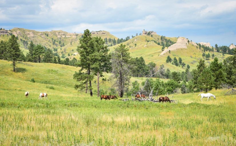
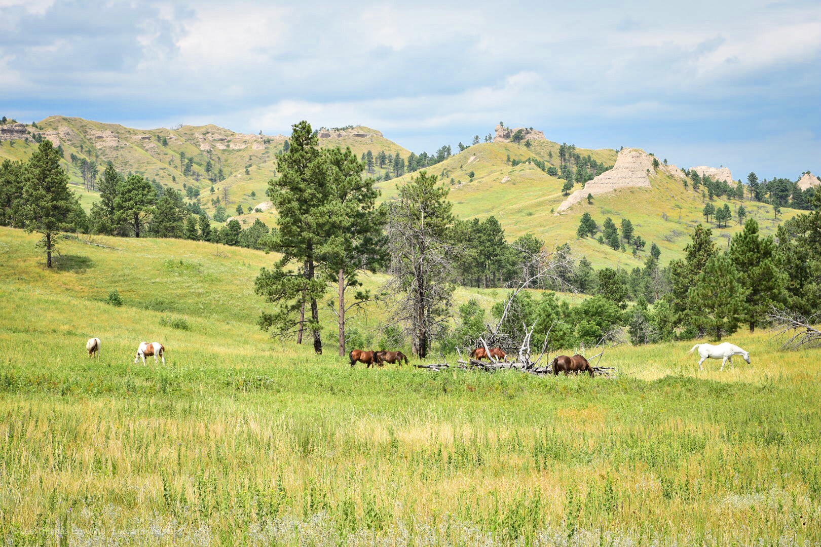
By the way it was a beautiful morning, even though a bit overcast. The clouds and the colored light of the rising sun really made the mountain in the distance to the Southeast look dramatic! My hike also caused me to cross paths with several creatures, including a big black beetle and several rabbits.

Breaking Camp

By the time I returned, Becky was already astir and ready to help break camp. We got everything put together by 7am, but I had to take advantage of the much brighter light to get some photos and video before we left…which didn’t happen until about 7:20 or so.

Pit Stop In Casper

We stopped just inside Casper for gas, mostly so I could clean the windshield and of course, pee again. I really picked the wrong gas station though…an older gentleman stood outside the restroom…and there was a handwritten “OUT OF ORDER” sign on the men’s room door. He sheepishly went into the women’s room, and then came out saying something about the flapper on the toilet…oh man. I walk in, see the cover off of the toilet tank and decide I’ll figure it out, and tried to close the door. Seriously??? The door was not properly hung, so I couldn’t close it! I didn’t have the time to monkey with it, so I closed it as much as possible and hoped for the best. I did have to make sure the flapper in the tank didn’t get hung up on the lever pulling it open, but otherwise everything went fine after that.

I ran back outside to work on the windshield and apologized to Becky for picking the worst possible gas station. I guess it was clean…but they really need a handyman to get things in proper order. Becky came back a couple of country songs later (the pickup truck song really got me working faster) and we got back on the road.

A New Route To Yellowstone (For Us)

Now the usual road to Yellowstone for a lot of people from the East is to cross South Dakota and most of Wyoming on I-90, and then to take either US-16 from Buffalo or US-14 from Rochester. We did that route with US-16 on our first trip back in 2015, passing through Ten Sleep Canyon and Cody. Since we were coming through Casper farther south this time, we would continue to follow US-20 and pass through Cody again. This would give us an opportunity to see some new parts of Wyoming.

I-25 between Douglas and Casper mostly follows the North Platte River, with mountains off in the distance, mostly to the south. After we diverged to stay on US-20, the road basically passes through barren lands without much of a view of anything but grass, sagebrush, and an occasional oil or gas well until you get to Shoshoni.
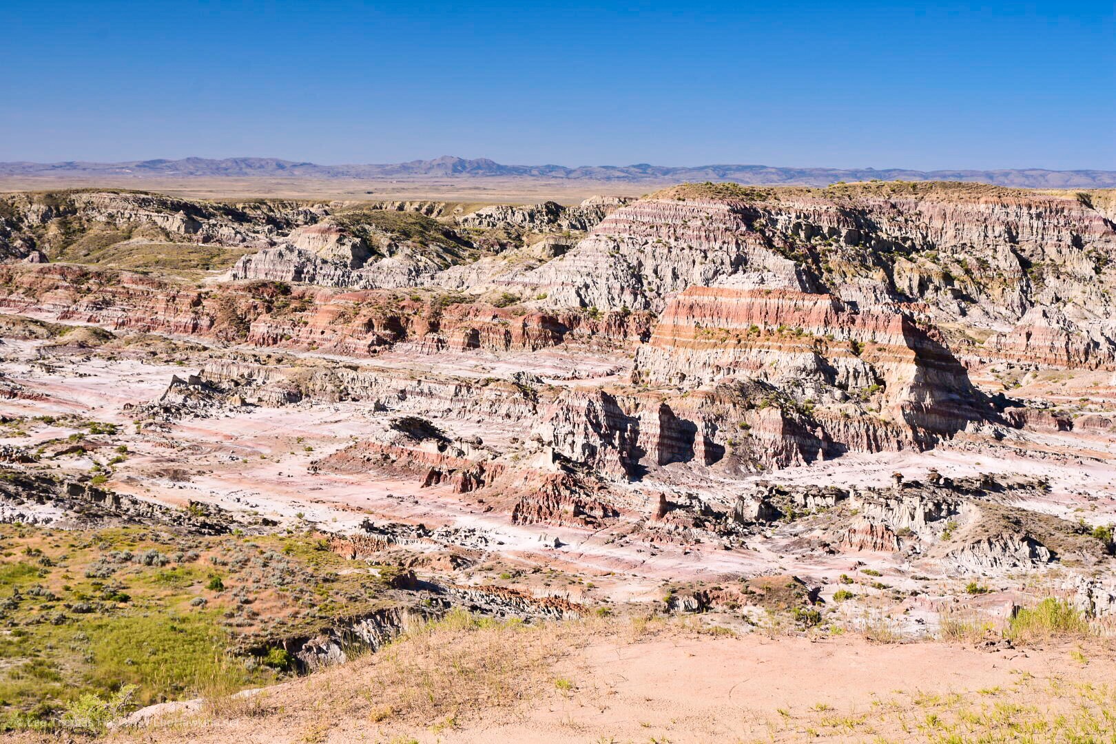
Hells Half Acre

Our first stop, Hells Half Acre, breaks up this drive. This rugged canyon actually sprawls 320 acres, and appears to have at some point had a building there, but all that’s left now is the foundation.

A multilayered jagged rock wall in a canyon with mountains in the distance against a blue sky
Hells Half Acre on US-20/26 west of Casper, Wyoming

Continue reading RealImaginaryWest 2019 Day 4—Our Return to Yellowstone

RealImaginaryWest 2019 Day 3—Nebraska’s Bridges To Buttes Highway & Beyond

Waking Up On the Niobrara

Turning In By Moonlight

I forgot to mention in last night’s post that I finished packing up by moonlight. The campground at Smith Falls so far as I could tell lacked artificial lighting, so my eyes were able to adjust very well. It’s incredible that a 3/4-full moon could light the night up so well, and for the most part we modern humans have no idea how well our eyes adjust to it because of all the artificial light we surround ourselves with. The funny thing about it is that orange or yellow light from a fire doesn’t prevent your eyes adjusting to the moonlight. Had it not been for me sitting there in just firelight, I don’t think I would have realized how bright the moonlight was.

Getting Started

Anyway, I think I may have actually slept reasonably last night. And my mattress stayed inflated all night too! On last year’s trip I realized it was losing air when we camped at Yosemite. I found a tiny little hole on the bottom and patched it up earlier this season. After two weekend camping trips since, I wondered if a leak might still be present because it seemed to still lose air, albeit more slowly. Perhaps that was not the case.

I stirred around 5:30am, about an hour before sunrise. The moon was gone but the sun had alrighty begun to intrude with first light. The entire campground was quiet with the exception of the tranquil flow of the Niobrara River.

Becky awoke around 6:15. We witnessed some brilliant red colors this morning—I should have thought about that saying, “Red sky in morning, roadtripper take warning,” or something like that. We certainly ran into some weather today…but I get ahead of myself.

What’s With the Humidity?

The first weather we noticed last night was the humidity. Smith Falls State Park is just west of the 100th Meridian, which is about where the altitude of the Great Plains increases and in turn the climate becomes more arid. In general, you can grow crops without relying heavily on irrigation east of the 100th Meridian, but not west of it. We’ve noticed in years past that the air is generally much dryer overall than it was tonight. It felt positively clammy well before sunset—more like an Ohio summer.

When we woke up this morning, our tent was soaked from the dew. We’d left the rainfly open last night to get airflow since it was rather warm. I made the mistake of leaving my sandals out in the open and they were terribly wet. Once we bit the bullet and got down to business, we made short work of packing the bedding and tent, leaving the campground around 7:30am.

Real Food For Breakfast!

Our original plan included a full day of stops at a few more places in Nebraska before heading into Wyoming for the night. One of these was Toadstool Geological Park, which sounded wonderful, but required a 13-mile drive down a gravel road. Maybe we’ll try that in the future during a more normal dry year when the road is less likely to be flood damaged like we saw in the campground in Smith Falls State Park.

Since we’d dropped Toadstool, that freed up plenty of time for us to get real food for breakfast! We headed into Valentine and ate a full breakfast at the Bunkhouse Restaurant in the center of town. The service was great, and the food was good diner fare that hit the spot for us.

The Bryan Bridge

After breakfast we headed south of town a mile or two to check out the Bryan Bridge, which used to carry US-20 across the Niobrara River. On the opposite side of the new US-20 bridge sits an old railroad trestle that now carries bicycles instead of trains.

The entire area around Valentine has incredibly beautiful terrain! The hills around town are lovely, and the Niobrara River seems like a wonderfully quiet place to canoe or kayak through them.

Northwest Nebraska

Not far west of Valentine, the terrain becomes less rugged with more rolling hills and fewer trees. The aridity west of the 100th Meridian certainly becomes apparent. We drove about two hours through another handful of very quiet tiny little towns.

As we approached Chadron the terrain changes again. Along with rolling hills, rocky buttes began to impose themselves on the horizon. Chadron was a bit larger than Valentine and even had Walmart. Here we turned south to visit Chadron State Park.

Chadron State Park

The buttes only became bigger and more concentrated as we approached the park. This area reminds me very much of the drive between the Badlands and Black Hills on Highway 44 in South Dakota and Wyoming. We pulled into the park office, paid the $8 out-of-state day-use fee, and headed up the park’s scenic drive.

I wanted to see the Blackhills Scenic Overlook, but the narrow high-crested gravel road made us rethink this. We instead continued on the scenic drive past a picnic shelter with a nice retro playground near the horse pasture. We didn’t stay long here since we hoped to get to our campground for the night a bit earlier than originally planned, and we still had one more stop…

Horses graze in light-green grass meadow with grass-covered peaks in the background. Evergreen trees dot the meadow and the peaks.
Horses grazing in a pasture at Chadron State Park in Northwest Nebraska

Continue reading RealImaginaryWest 2019 Day 3—Nebraska’s Bridges To Buttes Highway & Beyond