RealImaginaryWest 2017 Lite Day 3 – Roasting in the Badlands & Relief in the Black Hills

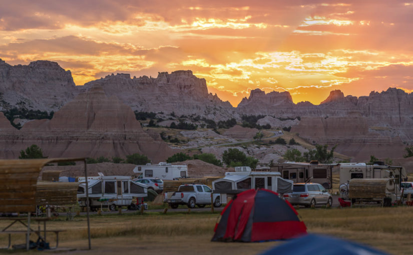
After a very early start at Badlands National Park, we packed up camp and made a short hike at Saddle Pass, followed by hikes on the Notch, Window, and Door Trails. Before driving the Badlands Loop Road and heading to Wall Drug, we returned to Cedar Pass Campground to get showers. After lunch and a couple of hours perusing Wall Drug, we took I-90 to Rapid City and SD-79 & SD-36 into the Black Hills and Custer State Park. Finally we followed US-16A to Bismarck Lake Campground near Custer in Black Hills National Forest.

Well today had a pretty good start with a rather dry finish… I suppose another way of putting it would be, “The Great Plains strike again!” Let me start at the beginning…

Sunrise at Badlands National Park

It all started at about 4:30am for me. I didn’t quite sleep as long as I’d hoped, but I did feel OK. The eastern horizon was already alight with the impending sunrise and birds were up singing. And just like last night, except in reverse, the moon was close to setting in the west.

Since we got to bed fairly early the night before and the forecast high would likely surpass the century mark, I woke Becky. It wasn’t supposed to get truly hot until late morning or noon. If we got up now, we could do some hiking and beat the heat as well as the crowds. While Becky moseyed to the restroom and got herself ready for the day, I packed up the tent and everything inside. We might come back later to cook or take showers, but there was no need to leave the tent up since it was already bone dry. I’m proud to say I had our bedding and tent all packed up solo in 25 minutes.

Just as the sun began to peek through the clouds over the Badlands wall, I ran off and shot a panorama of the brilliant sunrise! There were some reds but mostly oranges and violets. I would have shot the moonset too, but clouds on the western horizon totally obscured it.

Saddle Pass Trail
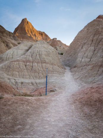
 

Looking up the Saddle Pass Trail in Badlands National Park. Blue markers help to identify the trail amid the indistinct terrain.
Looking up the Saddle Pass Trail. Blue markers help to identify the trail amid the indistinct terrain.

We were on the road before 6am and drove the short distance to the Saddle Pass Trailhead. The temperature was comfortable for now, around 70 degrees and low humidity. The Saddle Pass Trail is short at only 1/3 mile, but it’s a steep 216-foot climb up to the top of the Badlands wall.

We were on the road before 6am and drove the short distance to the Saddle Pass Trailhead. The temperature was comfortable for now, around 70 degrees and low humidity. The Saddle Pass Trail is short at only 1/3 mile, but it’s a steep 216-foot climb up to the top of the Badlands wall.

We started up the trail around 6am. It starts out exceptionally steep and has loose gravel footing. We were nearly halfway up when Becky decided she couldn’t go any further. It was just too much for her first thing in the morning. All the literature promised 360-degree views, so I decided to continue up to the top. The view did not disappoint!
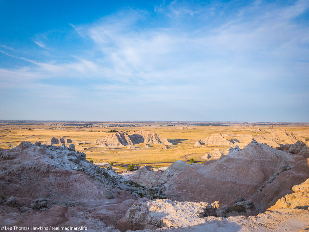
Looking south from Saddle Pass in Badlands National Park.
Looking south from Saddle Pass. The tiny black thing in the parking lot near the tree is our car!

After shooting a few photos, one of the car from all the way up on top, I headed back down. There’s a trail that runs along the top of the Badlands wall, but I didn’t check it out because I wanted to make sure Becky was OK. I was off the trail and back at the car just 45 minutes after we arrived. Becky was starting to feel better and suggested that she probably just needed something to eat to get her energy up. While I’d guess our bodies were still on our usual Eastern Time Zone schedule, it was probably just too quick of a start to the day for her.

Up to the Door/Window/Notch Trailhead
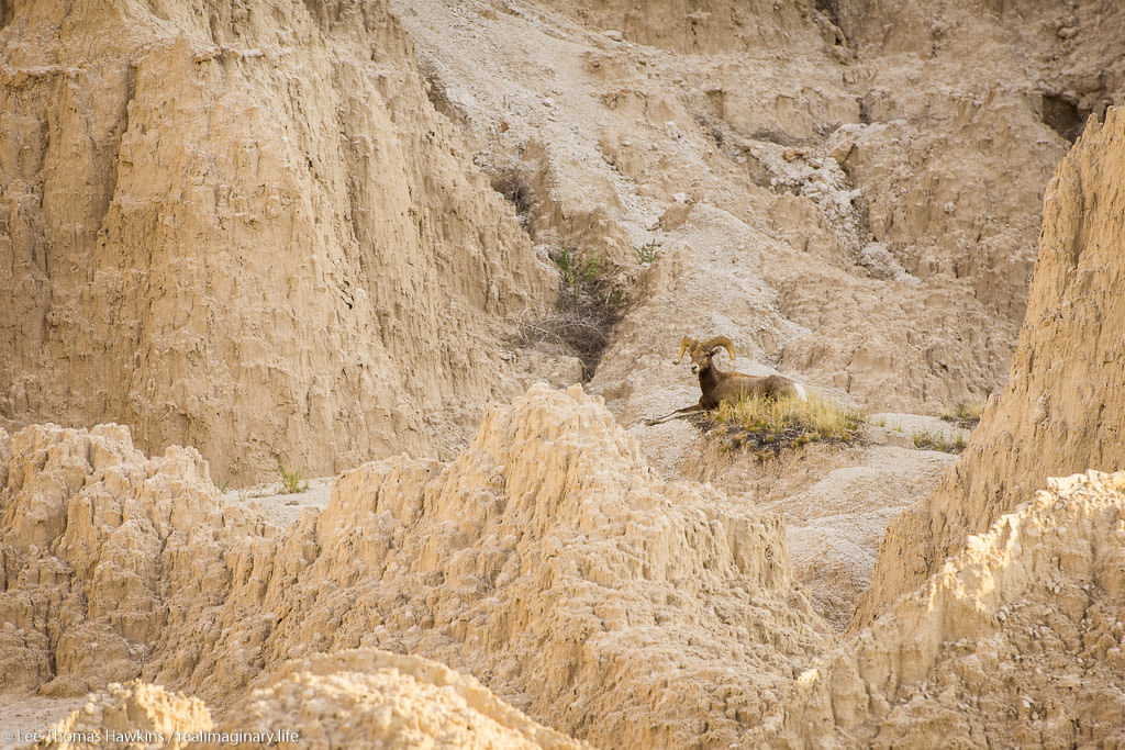
A bighorn sheep rests in morning shade north of Cedar Pass along the Badlands Loop Road in Badlands National Park.
A bighorn sheep rests in morning shade along the Badlands Loop Road on our way to the Door/Window/Notch Trailhead.

When we visited Badlands back in 2015, our only real hike here was the Door Trail. The same trailhead actually has two other trails, the super short Window Trail, and the more challenging Notch Trail. None of the three trails are particularly long, so we had plenty of time to do all three if we wanted to. The sky was crystal clear with bright sunshine now, but the temperature was still comfortable.

We made it to the parking lot around 7am, still well ahead of the crowds. We started with the Notch Trail, which is only 1.5 miles round trip. It winds through a small canyon for about 1/3 mile or so, and then there’s a ladder that takes you up to the rim so you can continue through a slightly larger canyon. We somehow missed the ladder, and realized it when the trail suddenly ended at an impasse. We could hear people just above us, so we retraced our steps. Turns out we followed a wash and went right past the ladder. It’s pretty easy to get disoriented and lose trails here! Almost all of them, including Notch, are actually marked with stakes at regular intervals so you can tell you’re going the right way.
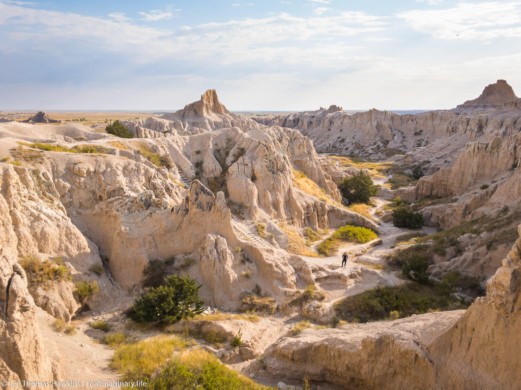
Becky awaits my return as I hike the section of the Notch Trail above the ladder.

A Perilous Wrong Turn

Becky took a look at the ladder and gave it a nope. I’m afraid of heights and didn’t find it at all intimidating. The easy slope and the grip of my hiking boots made it easy to walk upright the entire way.

I then made my way around the rim and came across some signs that got me confused. One said “KEEP RIGHT”, and the other was an arrow pointing at what I thought was the way to go. I’d heard the Notch Trail could be challenging, but I was surprised it would go right up this steep wash. I forgot to even look for a marker stake. Before I knew it, the wash got too steep and too loose to safely go any further—obviously a dead end!
Continue reading RealImaginaryWest 2017 Lite Day 3 – Roasting in the Badlands & Relief in the Black Hills

RealImaginaryWest Day 6 – The Black Hills, Mount Rushmore & Wind Cave

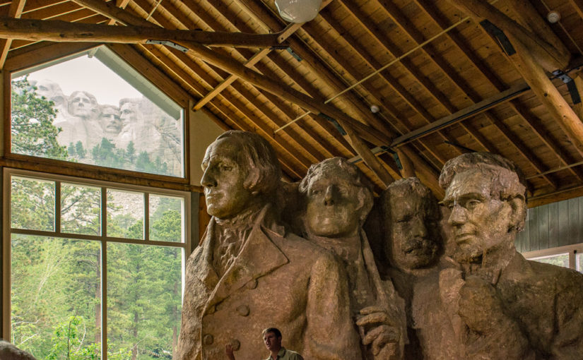
The weather held up really well, with just a little rain falling on us south of Rapid City as we drove from Badlands National Park to lunch in Keystone. We visited Mount Rushmore and got down to Wind Cave National Park just in time to catch the Natural Entrance Tour. Then we drove north into magnificent Custer State Park—WOW!—and finally made our way to our motel in Rapid City via the spectacular Iron Mountain Road.

Dreaming of the Old West

After a positively uneventful and peaceful night in Cedar Pass Campground at Badlands National Park, Becky and I woke up refreshed, and packed up our tent bound for the Black Hills. Becky cooked eggs in a tiny little portable stove she bought that resembles more of what a caterer uses to keep food warm than an actual stove. This was what we had to use to cook at Badlands, since there were no campfires allowed due to the risk of prairie fires. It took a while to cook a single egg, but it was effective.

After seeing I-90 and the Badlands Loop Road, I thought it would be best to drive to Rapid City via SD-44 so we could see the other side of the Badlands. Few likely see this area, since it is a much less popular part of the park. This was a great drive, which starts by going through the tiny little town of Interior, then passing through the town of Scenic, and finally to South Dakota’s second-largest city, Rapid City.

SD-44 straggles the border between Badlands National Park and Buffalo Gap National Grassland as it stretches West toward Scenic and Rapid City.

Black-footed ferrets, once extinct in South Dakota, prey almost exclusively on prairie dogs for food. They were reintroduced to the wild here in the 1990s, and as a result prairie dogs are protected in Buffalo Gap National Grassland.

Most of the way was either within Badlands National Park or Buffalo Gap National Grassland. The road runs alongside an abandoned railroad line where small wooden trestles still cross creeks, just without the rails. There were also plenty of pulloffs where you could drive into the grassland on dirt roads. Signs said that this was a management area for the black-footed ferret, which was thought extinct in the late 1970s. A few years later they were spotted again in Wyoming, and eventually reintroduced in areas such as this one. For the majority of the route we could see badlands going on for miles and miles and miles.

The railroad line crossing all of the creeks just a few feet above was odd to me. The fact that the creeks had grass all the way down to the water along their entire banks was strange to me too. Back East, the railroads are built far above floodplains, and there are trees and underbrush all around creeks and rivers, and pretty much just mud on the dropoff into the creek. The rolling hills and twisting and turning railroad bed conjured up all sorts of westerns and cartoons I’d seen all my life with scenery like this. When we entered into Black Hills country, it especially felt like I was living in an old western movie, except that technology and the 20th Century had happened and it was a little different now. It was strikingly beautiful country, and a lot of the things I’d seen in stuff set in the Old West started to make sense. I could imagine riding a galloping horse through this valley and on up into Rapid City with the rolling prairie on either side of me, and with the first pines appearing in the Black Hills.

Writing the Itinerary As We Go…

Now today had me a bit nervous…up to this point, we had all of our accommodations planned and/or reserved well before we left, except for the motel in Wisconsin. I had also managed to score three nights worth of campsites in Yellowstone online the day we left, and after that nothing was reservable anyway. The one and only night I hadn’t planned out was tonight…I figured on getting a campground as close as possible to Mount Rushmore. I thought it would be good to be able to capture it at sunrise in case sunset didn’t work out, plus it would eliminate any extra driving at the end of the night and hopefully we’d be able to relax. Unfortunately, there were zillions of campgrounds in the area and I had no opportunity to research many of them. The ones I did check were all super-expensive, as in might-as-well-get-a-motel expensive.

When we got cell service back again and I could check the forecast, the potential rain and the possibility of having another repeat of DeSmet weather settled it! I Googled around and found a motel—the M Star Rapid City. It was the cheapest thing I could get, and it was close to I-90, so I jumped on it. That was settled!

Now it was time to decide which destination to hit first…there were two on our itinerary. I’d originally planned on going to Wind Cave National Park first thing, then heading to Mount Rushmore by way of the Iron Mountain Road and seeing Rushmore closer to sunset. This would give me the opportunity to photograph the sculpture both in the Golden Hour and after dark when it’s all lit up. It was still partly to mostly cloudy, but the forecast called for overcast and possibly rain in the evening. This significantly reduced the probability of getting any interesting shadows or blue sky—and it shouldn’t matter what the weather outside is to tour inside a cave—so we elected to hit Rushmore first after we grabbed lunch.

We got a bit of rain between Rapid City and Keystone. I’d never seen a freeway interchange with wood-framed overpasses like this one at the junction of US-16 and US-16A!

The drive out of Rapid City and deep into the Black Hills was peppered with many and varied tourist traps. Several were totally designed to grab an eight-year-old’s attention so that they would pressure their parents to visit. I still have to admit, a few were tempting to check out.

Right before Mount Rushmore, you go through the town of Keystone, which seemed to have more hotels than residents. Again, there were many and varied tourist attractions, several of which were themed around the presidents and their history. We stopped at the Grizzly Creek Restaurant to try their burgers. I went for the bourbon burger and Becky had the buffalo burger. They were tasty and hearty, but not remarkable for the price. They have ten beers on tap, two or three of which were the standard Miller and Budweiser choices, while the rest were all local microbrews. We still had a lot ahead of us for the day, so I decided not to have anything after I tasted a sample of the only beer that really sounded good to me—which was a wheat beer that tasted too hoppy for my liking.

Mount Rushmore National Memorial

The clouds were just beginning to subside as we caught our first sight of Mount Rushmore from SD-244.

Mount Rushmore was a busy place, probably the busiest we’d seen so far on this trip. It was nowhere near congested though, especially compared with just about any of the major tourist attractions in California. As you drive up on SD-244 to the monument, you actually catch your first site of it, which is pretty striking. At the entrance are ticket gates where you have to pay to park in the massive deck they built back in the 1990s. Unfortunately, the Annual Pass we just bought at Badlands doesn’t apply here, as a separate organization operates the parking deck. Finding parking was not too difficult, and neither was making our way up to the monument.

Mount Rushmore towers over the grand entrance to the memorial from the parking decks.

Continue reading RealImaginaryWest Day 6 – The Black Hills, Mount Rushmore & Wind Cave