But we didn’t just head West last year…we headed south during the peak fall foliage and toured historic and scenic places in Appalachia as well. We had a week off and saw parts of Southern Ohio we’d never seen, drove along the eastern edge of Kentucky and into the western tip of Virginia to visit Cumberland Gap, and then camped and hiked in Great Smoky Mountains National Park and Cherokee National Forest along the Tennessee-North Carolina border.
Our road trip camping throughout the West emboldened us to do things we’d never done before. I never thought I could camp in a tent if the temperature dropped below 50 at night. I would never have dreamed that we could pretty much fly by the seat of our pants and find motels and campsites pretty much wherever we wanted to go. While it was nerve-wracking at times, I learned a lot about planning a road trip like this and so of course we had to do it again to apply what we learned and go see more!!! The Appalachian road trip was an outgrowth of this emboldening, but to really truly test ourselves, we needed to Go West yet again…
Lightning in a Bottle?
When we packed up our tent last October, we were ready to be done camping for the season and sleep in our bed for the next few months. As the fall and then winter went on and spring approached, we already had the fever to get out with our tent again! I pulled out the maps and decided to mark all of the national parks we still hadn’t seen, and began looking for a route that would allow us to see several parks in one trip like we did in 2015.
Last year’s trip was pretty easy to plan. It all started because Becky wanted to see where Laura Ingalls Wilder lived, and I saw that those places would make an easy path west to see four national parks, and that we could then swing south to visit one more in Colorado before visiting my aunt and cousins in Denver for the first time in 29 years. It really felt like the trip of a lifetime, but then again, my trip around California in 2008 felt like the trip of a lifetime too…so even though I felt like we’d captured lightning in a bottle, my prior experience made me think that just maybe we could do it again…I mean, it can’t hurt to try, right???

We Started with Glacier
So there are two problems to overcome in planning a similar trip: 1.) which western national parks would be an awesome experience like the ones we visited last year, and 2.) how do we make the trips across the Great Plains worth being on the road instead of wishing we had flown.
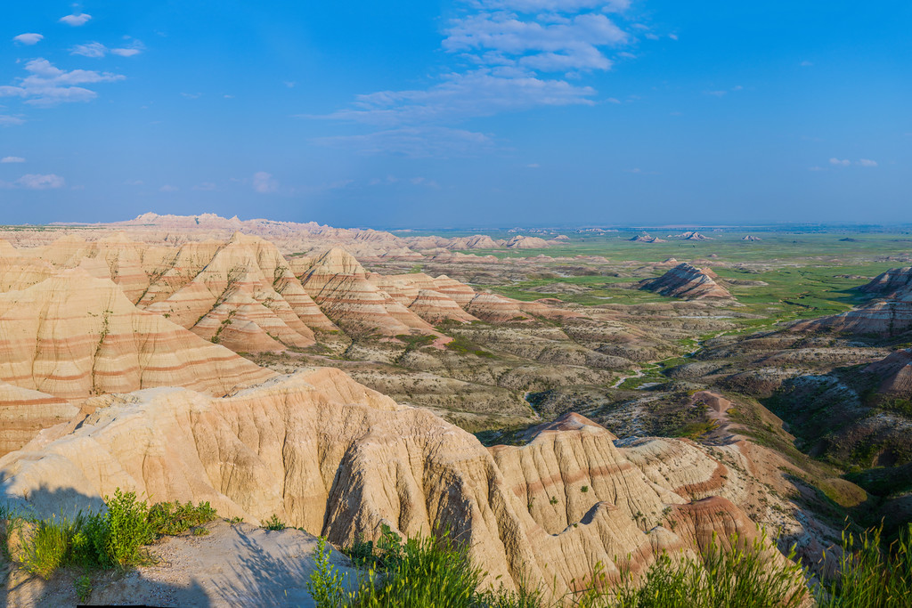
Solving the first problem seemed to have an easy enough starting point. For last year’s trip, I really hoped to include Glacier National Park on the itinerary…but it really was too far away from Yellowstone to have enough time to do much more than drive for the entire trip…and so it was scrapped. This year it seemed reasonable to start with Glacier as the main feature, and see what else we could add around that. In 2015, we also regretted spending only one night in Badlands National Park—we would have loved a full day just to hike some longer trails and really get to know the place—so it seemed perfect that we would stop in Theodore Roosevelt National Park, in the North Dakota badlands on either the beginning or ending leg of the trip.

Since Glacier and Theodore Roosevelt are the only two national parks north of our 2015 route, our best choice for seeing more parks was to look further west—and that put us in the states of Idaho, Oregon, and Washington. Idaho has no national parks, but Oregon has Crater Lake National Park, and Washington has three national parks: Olympic, Mount Rainier, and North Cascades. Since I’d already marked a map with national parks, I realized that Crater Lake was best left for another trip that would include national parks in Northern California. Also, I had long desired to see the temperate rain forest I’d read about since middle school along the Pacific Ocean in Olympic National Park. This would also give us a chance to perhaps spend time in Portland and Seattle.
So that left the second problem—how do we get all the way to the West Coast without simply driving and stopping in nondescript motels and campgrounds and getting bored crossing the Great Plains? Last year we learned that the Great Plains aren’t nearly as empty as we are left to believe. They may not be New York City or Yosemite, but we really enjoyed what we saw last year and we’d like to find that again too.
The Oregon Trail

If you lived through most of the 80s, at some point you had to have seen the Oregon Trail game on an Apple II. You remember fording the Kansas River, stopping at Fort Kearney for supplies, seeing the 8-color picture of Chimney Rock, hunting for game, passing through Soda Springs, and half of your party getting dysentery or cholera and dying. I had always thought it would be awesome to travel the Oregon Trail myself (except for the dysentery and cholera, of course)! This all seemed to fit into our 2016 road trip, and would be an easy way to find proverbial roses to smell, seeing some cool sights and history on our way west.
The official start of the Oregon Trail is in Independence, Missouri, which is near Kansas City, and the end was Oregon City, Oregon, which is now a suburb of Portland. What is not so well-known is that as time went on, many settlers departed for Oregon from any of several places along the Missouri River, ranging from Independence, Missouri all the way up through Council Bluffs, Iowa and Omaha, Nebraska. Another factoid is that the Oregon Trail also runs concurrently with most of the California Trail, which saw an explosion of emigrants in 1849, the height of the California Gold Rush.
So in the interest of time and photography, we are going to spend most of the first four days of our trip loosely traveling the route of the Oregon Trail. That puts us in Portland, only three or four hours from Olympic National Park on the Pacific Coast, and sets us up to meander our way through national parks on our way back across Washington, Idaho, and Montana. From Theodore Roosevelt National Park in Western North Dakota, we’ll have two full days to drive the 20 hours it takes to get home, with a likely stop in Minneapolis.
The Final Itinerary
Once we had the bones of what we wanted to do, I needed to figure out how long it would take to do everything we had on the list. The first order of business was to calculate the travel times for each section and guesstimate how long we would spend at each location. While I worked forward and backward from Glacier National Park in planning the basic outline of the trip, I needed to dig into details to work out the rest…and this required working from the ends toward the middle, since we were constrained on when our trip could start and end. There was also the photography to consider, and since the best light of the day is around sunrise and sunset, I had to make sure we got to key locations of interest at good times of the day.
If this is all starting to sound boring, then nevermind and skip to my itinerary page to see the results. If instead this all sounds to you like another interesting blog post, then you may read on (coming soon)…where I will take you into the data quagmire and hopefully bring you out with some useful information. And where hopefully I have arrived at a doable itinerary…