RealImaginaryWest Day 13 – Grand Teton National Park to Craig, Colorado

After a boat ride and a short hike up to Inspiration Point at Jenny Lake, we depart Grand Teton National Park and Wyoming for Craig, Colorado. This takes us most of the way to Rocky Mountain National Park, where we head tomorrow.

Waking Up

After a few days at altitude slowly dehydrating me and making me feel like garbage each morning, waking up today was really easy. First light came, and my bladder reminded me of how much water I’d been drinking to rehydrate after yesterday’s visit to the hospital in Jackson. My bladder woke me up around 1:30am too. Oh the price we pay to stay healthy while roughing it…

More Wet

Once I’d returned from the restroom and was able to consider less urgent matters, I noticed our tent was covered with water droplets. I complained to Becky about how wet everything was still…and she informed me that it had rained again overnight. Grrr!!! That explains it! (I must have slept better than I thought!)

Since we had to pack up this morning, this was disappointing. It became downright frustrating when I realized that water was inside the tent again too, and that all of our damp towels left out to dry overnight were now quite soaked instead. I did not expect rain to be this much of a problem out West where summers (I thought) were mostly dry.

Most of all I was beyond irritated with our tent. Every time it rained, water got inside. I really expect any tent I own to do two major things: 1.) keep me warm, which this tent was not great at, and 2.) keep me dry…major fail. I came to find out later that you’re supposed to seal these things at least once a year. (You’d think they’d put that in the setup instructions!) And maybe it’s unrealistic on my part to expect a three-season tent to be all that warm.

Anyway, expectations aside, our Coleman Rosewood 4-person tent is a great starter tent. But this road trip did expose some weaknesses. It didn’t ventilate exceptionally well in the heat, but it also didn’t hold onto heat overnight. Also, the poles are made of fiberglass, and break easily even under extraordinary care—they’re also not easy or even possible to repair, and replacements cost almost as much as the tent. It also has a high profile which gets flattened by strong winds like we experienced in De Smet, South Dakota. Maybe we’ll look into an upgrade for next year…

So with a soaked tent and soaked towels, packing up was going to be a drag. I picked up the driest towel I could find and started wiping. I still saw water droplets. Our entire rainfly was also wet on the inside…condensation from our breath in the cold air. We could probably pack everything up now and dry it off in Craig, but I wasn’t fond of having a damp tent in the car all day long. Tonight’s rain potential had also inched up from 0% to 10%. Awesome. Ten percent seems to be all it takes this summer.

The best course of action seemed to be to leave the tent up to dry here for a few hours. This meant an extra hour of driving from Colter Bay to Jenny Lake and back from our hike, and tacking on an extra 30 minutes to our drive down to Craig. And checkout time is at 11am. Bummer.

Off to Jenny Lake

By around 7am we had everything but the tent packed up, and we were on our way to Jenny Lake for one last hike before leaving Grand Teton National Park. Yesterday the plan was to take the shuttle boat across and hike up into Cascade Canyon. Since we had a 6-7-hour drive ahead of us, we’d do an abbreviated version of that this morning. The shuttles run 10 minutes apart, so I guessed it must take just under 10 minutes to cross the lake. With a 30 minute drive back to Colter Bay and another 30 minutes to dry off and pack up our tent, I estimated that we needed to be on a boat back a little before 10 o’clock. This would give us about two hours to hike—not a ton of time, but hopefully enough!

Along the way, I saw a sign for North Jenny Lake and a scenic drive. I remembered seeing this one-way road along the lakeshore on the map. Being impulsive and curious, I decided to check it out. It was a pretty little drive with a few pullouts and OK views along the lake, but it wasn’t anything seriously impressive like I’d hoped. My mind was wandering anyway…I kept thinking about whether we shouldn’t see about a late checkout to give us a little more time on the trails.

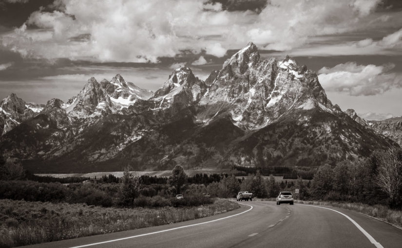
The light was beautiful, so I couldn’t pass up a quick stop at Willow Flats Overlook to capture a high-resolution panorama. This can be printed HUGE, since the original is 24817 pixels x 8272 pixels. The low-hanging clouds looked so cool!

I also grabbed this shot with a clearer view of Grand Teton.

This ground squirrel foraged around the fringes of the parking lot at the Willow Flats Overlook.

Parking at the Jenny Lake Visitor Center was a breeze when we arrived at 7:50! Coming in yesterday just before 11am put us at the peak of the crowds. Of course, it was time for me to hit the restroom again. Becky also wanted to comb the gift shop one more time to find a “Jenny Lake” souvenir for her best friend, Jenny, back home. This would easily take us up to 8 o’clock, which is when the camp office at Colter Bay opens. Before we get on the shuttle and leave cellular range, I could call and ask for a late checkout.

Unfortunately, Becky came up empty again. They only had stickers and fridge magnets, and everything else had sold out. We did, however, get OKed for a noon checkout! Awesome! Now we’ll definitely have time for a good hike.

Taking the Shuttle Boat

Round-trip fare for the shuttle boat across Jenny Lake was $15 per person. This seemed pretty steep for a short trip, but when you figure in the remoteness and the short four-month tourist season here, it’s more understandable. It would definitely save us time, too, as it shaved a six-mile hike to Inspiration Point or Hidden Falls down to only two miles round-trip. What really sweetened the deal was that they also sold Jenny Lake water bottles at the docks—so we had more water, and Becky finally had the gift she wanted for her bestie!

A shuttle boat head back to the docks by Jenny Lake Visitor Center.

Becky enjoys the ride across Jenny Lake in the crisp morning air.

The lake was very calm. Winds here seemed to be calm overnight and intensify with the sun throughout the day. Becky said she heard that Jenny Lake is hundreds of feet deep, which would keep the lake from getting too rough for very long. This made for a smooth ride across. The overnight storm had also left behind some beautiful low clouds between us and Mt. Moran.

I was a little torn between hiking to Inspiration Point or Hidden Falls. The driver taking us across shared that Hidden Falls was an easier trail but had no view, while Inspiration Point has an elevation change of 600 feet over the course of a mile and an extraordinary view at the end. We probably could have done both, but the trail in between was closed.

I asked the driver how long it took to get to Inspiration Point, and he way very vague. It was pretty difficult to judge someone’s physical condition and acclimation to the altitude. He said it takes him about 30 minutes, and that most people should expect it to take at least 45 minutes. This sounded like it would work for our timeframe, which at this point was a little over 2 hours.

Continue reading RealImaginaryWest Day 13 – Grand Teton National Park to Craig, Colorado
RealImaginaryWest Day 2 – Dwarf Mountains, the Great River, and a Little House

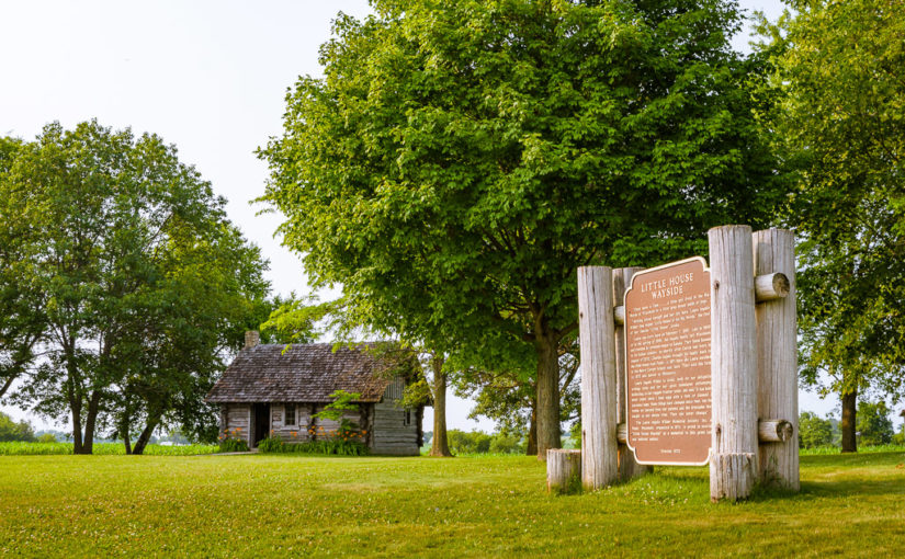
A replica of the log cabin Laura Ingalls Wilder lived in as a small child and a historical marker at the Little House Wayside in Pepin, Wisconsin

We drove from Motel 6 in Janesville to Pepin, Wisconsin, a village on the Mississippi River. Laura Ingalls Wilder’s book, Little House in the Big Woods takes place here, where she lived as a small child seven miles outside of town.

Today we got a much later start than I had hoped, but it seems like everything somehow worked out.

We left the Motel 6 in Janesville (they left the light on for us, but we turned it off before we left) right around 11am and headed north (or west…whatever) on I-90 past Madison and Wisconsin Dells on up to the Mississippi River.

The Driftless Area of Wisconsin

A row of Interstate Highway System shield signs indicating North I-39, West I-90, and West I-94

We were really impressed with the gorgeous rolling hills around Madison and on up through Wisconsin Dells. Everything everywhere was just wonderfully green and lush, and everyplace seemed very well-manicured and maintained, which is wonderful to see. Lots of times you would see modern industrial and commercial buildings, and sure enough, behind it would be a farm—something that is novel for me to see right next to suburban buildings.

Castle Rock as seen from I-90/94

Castle Rock as we passed by on I-90/94

Now once we got further north, the flora seemed to change to having more conifers in the mix and things weren’t quite a lush green anymore—they were more of a California or Rocky Mountain green, but not quite that color. It also got hazier and hazier, and that was likely because smoke was blowing in from forest fires burning all the way up in Canada. What was also strange was that there were huge valleys that would open up, and lots of times you’d even see small mountains that were too small to be considered officially mountains—maybe we could call them “dwarf mountains“. You’d see naked rocks that looked as old as time standing in the middle of a bunch of trees next to the freeway too…something else that I never associated with Wisconsin or Minnesota.

Looking miles away down a hill on I-90 in Wisconsin at Jacksonville Pass

Jacksonville Pass, looking west near the 36-mile marker on I-90 in Wisconsin
Tree-covered King's and Queens Bluff towering above US-61

King’s & Queen’s Bluff from US-61 as it winds along the Mississippi River north of I-90 near Winona, Minnesota.

Eventually we passed LaCrosse and went over the Mississippi River into Minnesota on I-90 and US-61, which parallels the Mississippi. US-61 actually follows the Great River all the way into Minneapolis, and there are busy railroads on both sides of the river carrying trains. Many of the trains heading south are all tanker cars, probably full of North Dakota crude oil bound for refineries in Louisiana. All along the river there were heavily-wooded bluffs with dwarf mountains, knolls, knobs, and rock outcroppings breaking up the trees.

Pepin & Little House in the Big Woods

Laura Ingalls Wilder Museum sign in Pepin, Wisconsin

The Laura Ingalls Wilder Museum in Pepin

We crossed back into Wisconsin at Wabasha on MN-60/WI-25 to go to Pepin.  This is where Laura Ingalls Wilder was born and lived as a little girl, and where she got inspiration to write Little House in the Big Woods. They have a museum there, and about 7 miles out of town there’s a replica log cabin. Pepin from WI-35 seems unremarkable in town, with a few little stores you’d see anywhere else, and a little motel with a campground where we stayed. The biggest attraction on the main street was the Laura Ingalls Wilder Museum. Admission is only $5 and they have plenty of artifacts from the era when Laura and her family lived in Pepin Township, including cook stoves, clothing, tools, a covered wagon, and canoes used to fish on Lake Pepin.

Two children's dolls like those Laura had as a small child. One is a rag doll, and the other is made of a corn cob.

Dolls like Laura’s in Little House in the Big Woods. Her first doll, Susan, couldn’t help that she was a corn cob.

We met Dawn there, along with her mom, Mary, who just retired as the village clerk and was now planning to devote much more time to her position on the board of trustees for the historical society that runs the museum. They just expanded from a small building into two much larger buildings, and were in the midst of reorganizing and remodeling to improve their exhibits. All throughout the museum were artifacts, either with stories behind how they were used by the family, or with quotes from Little House in the Big Woods pointing out where Laura referred to them. There’s a video presentation on the history of Laura’s family in Pepin, along with other history of the area. Mary showed us on a big map from 1877 which lot Charles Ingalls had bought with his brother-in-law near the edge of Pepin Township. She explained how they found the information years ago by putting the word out for property owners to check their title abstracts for Charles Ingalls. She also shared the story of how she and the historical society worked to get grants and raise money for the museum to build a replica log cabin on the site of the old Ingalls farm at a wayside.  (In Wisconsin, small roadside parks along highways that we would call rest areas in Ohio are called “waysides”.)

Overlooking a fence and field with rolled bales, with a silo, several barns, and a farmhouse on the other side

A farm along County Road CC

We followed County Road CC out to the Little House Wayside Cabin, built in 1978 just a few hundred feet from where Charles & Caroline Ingalls started their family. The countryside round about the town was incredible! Beautiful farms and woods were all along the winding highway. We saw several farms that looked like they belonged on postcards.

Continue reading RealImaginaryWest Day 2 – Dwarf Mountains, the Great River, and a Little House