Well today had a pretty good start with a rather dry finish… I suppose another way of putting it would be, “The Great Plains strike again!” Let me start at the beginning…
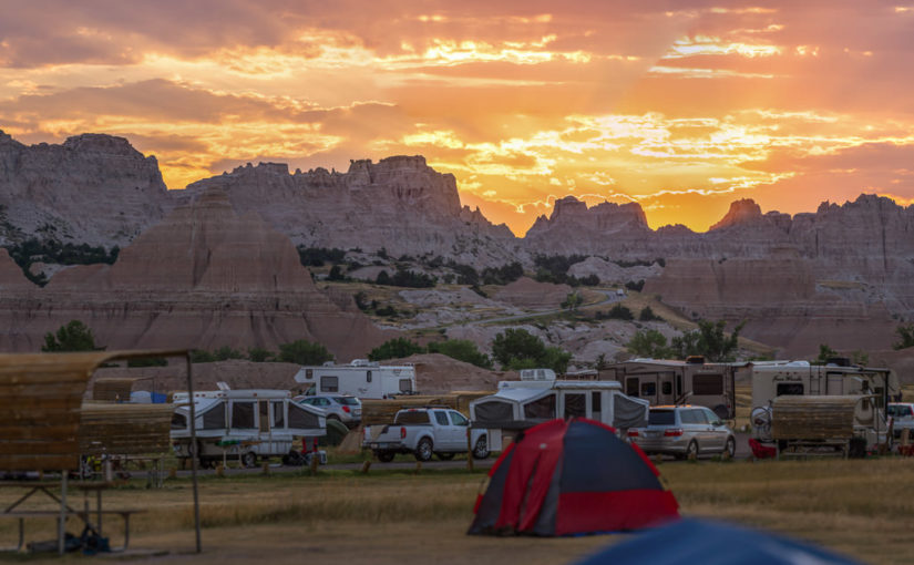
Sunrise at Badlands National Park
It all started at about 4:30am for me. I didn’t quite sleep as long as I’d hoped, but I did feel OK. The eastern horizon was already alight with the impending sunrise and birds were up singing. And just like last night, except in reverse, the moon was close to setting in the west.
Since we got to bed fairly early the night before and the forecast high would likely surpass the century mark, I woke Becky. It wasn’t supposed to get truly hot until late morning or noon. If we got up now, we could do some hiking and beat the heat as well as the crowds. While Becky moseyed to the restroom and got herself ready for the day, I packed up the tent and everything inside. We might come back later to cook or take showers, but there was no need to leave the tent up since it was already bone dry. I’m proud to say I had our bedding and tent all packed up solo in 25 minutes.
Just as the sun began to peek through the clouds over the Badlands wall, I ran off and shot a panorama of the brilliant sunrise! There were some reds but mostly oranges and violets. I would have shot the moonset too, but clouds on the western horizon totally obscured it.
Saddle Pass Trail
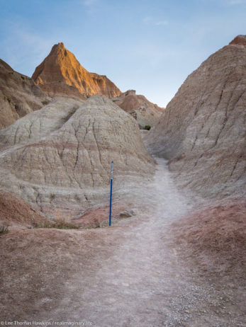
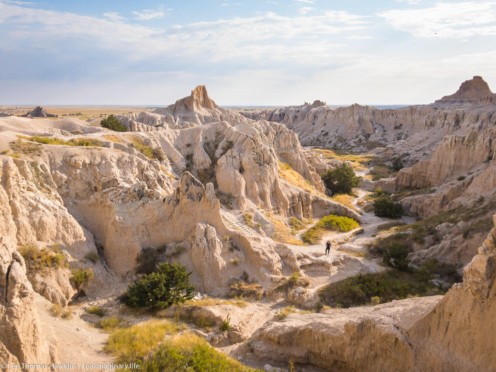
We were on the road before 6am and drove the short distance to the Saddle Pass Trailhead. The temperature was comfortable for now, around 70 degrees and low humidity. The Saddle Pass Trail is short at only 1/3 mile, but it’s a steep 216-foot climb up to the top of the Badlands wall.
We were on the road before 6am and drove the short distance to the Saddle Pass Trailhead. The temperature was comfortable for now, around 70 degrees and low humidity. The Saddle Pass Trail is short at only 1/3 mile, but it’s a steep 216-foot climb up to the top of the Badlands wall.
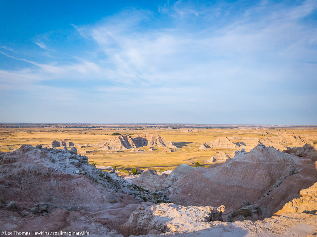
We started up the trail around 6am. It starts out exceptionally steep and has loose gravel footing. We were nearly halfway up when Becky decided she couldn’t go any further. It was just too much for her first thing in the morning. All the literature promised 360-degree views, so I decided to continue up to the top. The view did not disappoint!
After shooting a few photos, one of the car from all the way up on top, I headed back down. There’s a trail that runs along the top of the Badlands wall, but I didn’t check it out because I wanted to make sure Becky was OK. I was off the trail and back at the car just 45 minutes after we arrived. Becky was starting to feel better and suggested that she probably just needed something to eat to get her energy up. While I’d guess our bodies were still on our usual Eastern Time Zone schedule, it was probably just too quick of a start to the day for her.
Up to the Door/Window/Notch Trailhead
When we visited Badlands back in 2015, our only real hike here was the Door Trail. The same trailhead actually has two other trails, the super short Window Trail, and the more challenging Notch Trail. None of the three trails are particularly long, so we had plenty of time to do all three if we wanted to. The sky was crystal clear with bright sunshine now, but the temperature was still comfortable.
We made it to the parking lot around 7am, still well ahead of the crowds. We started with the Notch Trail, which is only 1.5 miles round trip. It winds through a small canyon for about 1/3 mile or so, and then there’s a ladder that takes you up to the rim so you can continue through a slightly larger canyon. We somehow missed the ladder, and realized it when the trail suddenly ended at an impasse. We could hear people just above us, so we retraced our steps. Turns out we followed a wash and went right past the ladder. It’s pretty easy to get disoriented and lose trails here! Almost all of them, including Notch, are actually marked with stakes at regular intervals so you can tell you’re going the right way.
A Perilous Wrong Turn
Becky took a look at the ladder and gave it a nope. I’m afraid of heights and didn’t find it at all intimidating. The easy slope and the grip of my hiking boots made it easy to walk upright the entire way.
I then made my way around the rim and came across some signs that got me confused. One said “KEEP RIGHT”, and the other was an arrow pointing at what I thought was the way to go. I’d heard the Notch Trail could be challenging, but I was surprised it would go right up this steep wash. I forgot to even look for a marker stake. Before I knew it, the wash got too steep and too loose to safely go any further—obviously a dead end!
When hiking, it’s important to remember that it’s usually easier to go up than it is to go down. I now found myself in such a situation! I felt stupid and started to panic a little bit. Panic is not helpful at times like this, so I took a second to calm down and look for the safest way back down to the signs where I took a wrong turn. I made it without any serious trouble, but I was a little scared for a minute or two there!
Back On the Trail and On To the Notch
Back down by the signs and undeterred, I looked around and said “Oh duh!” to myself as I saw the next trail marker. Had I remembered to look for the stakes, I would have easily spotted them. Lesson learned!
I made my way up through a wide and rather barren canyon until I reached a fork where there were no more trail markers. I heard a couple talking to the right, so I went that way first. It opened up to an expansive view to the southwest where I could see the platform at the end of the Cliff Shelf Trail and on down to the parking area where we stopped yesterday! I always wondered why the Notch and Cliff Shelf Trails didn’t connect to each other. Now I could see that there’s quite a chasm between the two!
I asked the couple if the fork to the left had a view too but they didn’t know. Before heading back I checked it out. If you only have time to pick one, I’d say the fork to the left is the best.
Back to the Ladder and to the Window Trail
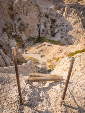
After a short time, I got back to the ladder and caught up with Becky waiting patiently in the shade. The ladder probably has a 45-degree incline at most, and was super easy to get up. It looked a little more challenging for the way down. After watching a couple of other people go down ahead of me, I made my way slowly but easily. Becky shot a pretty cool timelapse video of it!
We were back at the car rehydrating by 8am. Many more people were out now. Next we walked down the boardwalk 1/8 mile to the Window. There’s a wonderful view across the Badlands Wall here, and it’s 100% wheelchair accessible. This is really the only trail throughout the park like this, as most trails are rocky with loose gravel and plenty of steps.
The Door Trail
Since we still had tons of time this morning, we decided to go back to the Door Trail before we headed back to Cedar Pass Campground for showers. As I’d mentioned earlier, we took this trail last year. The first part is on a fairly level accessible boardwalk. Once you go through the Door, there are steps and a trail that heads out across the Badlands for almost 1/2 mile. Since the terrain is so gravelly and there are footprints everywhere, the only way you can find the trail is to follow the numbered yellow markers! You can see how this works for yourself on the video below:
Back at Cedar Pass Campground
By 10am, the temperature had gotten pretty warm. We’d spend the next six nights at campgrounds that do not offer shower facilities—so we wanted to get a shower now while we still had them handy here at Badlands. As the humidity remained a dry 40%, it was fairly comfortable in the heat. Unfortunately this also makes it difficult to tell how much we had actually been sweating. As soon as the water made its way down my face I got a strong salty taste from the runoff! All the running around I did on the Door Trail in 80- to 90-degree heat, had me working up a sweat I’d have never noticed in this low humidity!
This made drying off no problem at all. By 10:30am the temperature already neared 100°F. On top of that, the wind had picked up, turning the outdoors into a convection oven. There was a heat advisory up that warned of sustained 15-20mph winds with gusts up to 30mph! I’d endured 112°F about ten years ago driving across the Mojave Desert, but the wind that day was negligible compared to this…
Driving the Badlands Loop Road
We left Cedar Pass Campground at checkout time (11am) and headed west on the Badlands Loop Road. We took a nice leisurely pace and stopped at a few places we only whizzed past last time. Becky was really spent though, so I drove. I’m sure the heat was a factor, but she probably needed more sleep too. We were hungry, but there was no way either of us wanted to cook in this heat. It was 100°F now, and it was still pretty early in the day. I got out at several overlooks, but Becky stayed in the car at all but one or two stops.
One big risk in dry heat, especially with this wind, is hyponatremia. With such low humidity, your body cools easily because your sweat evaporates almost instantly. The upside is that it’s much more comfortable than dripping sweat like we always do back East. The downside is that you don’t even realize how dehydrated you are. And when you sweat, it’s not just about fluids—you lose a lot of salt too. When your salt levels get too low, it’s a dangerous condition called hyponatremia. The best way to prevent it is to eat salty foods. So Becky and I opened up a bag of potato chips and ate the whole thing as we drove.
Since the light at this time of day is pretty harsh and flat, I didn’t take many photos except to scout for our next visit. There aren’t many animals out at this time of day either. Most that are stay far far away from anywhere that people go. So in under two hours, we were on the western end of the Badlands Loop Road heading into the small town of Wall.
Wall Drug
If you’ve been anywhere along I-90 in South Dakota, you’ve heard of Wall Drug. Chances are actually good that you’ve seen bumper stickers or signs for Wall Drug just about anywhere in the world! It started out as a humble little drug store in the tiny little town of Wall, South Dakota. While the town remains tiny, its drug store has grown to epic proportions and become an iconic attraction unto itself in the American West.
Five Years to Make or Break the Husteads
The story starts when Ted & Dorothy Hustead bought the drug store in 1931. A long drought and the Great Depression were on, so the farm town of Wall was not just small, it was poor too. With only a trickle of customers, and not enough to keep up with all the bills, Ted figured on giving the store five years to become successful. Nothing changed until Dorothy got an idea in 1936…
Western towns are not built like most towns East of the Mississippi. In the East, Main Street doesn’t just run within a town’s business district, it’s usually the main road going across and out of town as well. Railroads came decades later. In the West, however, few towns existed before settlers arrived, and most of those built up along rivers for transportation. Therefore not many actual roads existed. Almost every Western town developed around the railroad, with Main Street extending away from the railroad depot. When the automobile came along and a national highway system developed, the roads connecting towns almost always bypassed the busy central business districts.
So in 1931, the new US highways ran around Wall’s business district with motorists never giving a thought to stopping. Lots of people drove through the Badlands on what was then US-16A, but none thought of taking a break at the little drug store just 2-3 blocks off the highway… Until Dorothy Hustead suggested that they should put up signs offering the weary motorists free ice water one day in July 1936. (It’s worth pointing out that air conditioning and cupholders were still a long way off even for luxury cars back then!) Before Ted had finished erecting the signs the next day, business had already picked up. Fast-forward 80 years, and signs have not only kept the Hustead family in Wall, but they’ve also grown Wall Drug into a multi-million dollar business!
Wall Drug Today
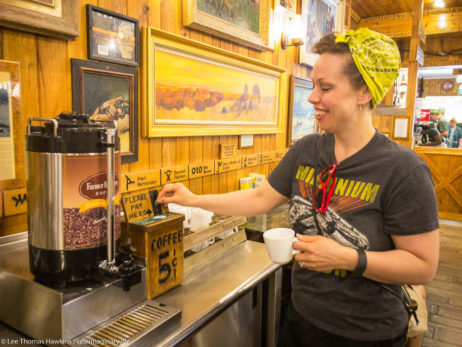
Today there are dozens of signs in either direction for hundreds of miles along I-90 advertising Wall Drug! You can still fill prescriptions there, but you can also buy t-shirts, leather goods, camping supplies, books, and Western art too. You can still get ice cream, and now they also have a full restaurant offering breakfast, lunch, and dinner. They still have 5¢ coffee and free ice water too…
The signs will absolutely compel you to stop to check this place out! And for us today, the free ice water was a huge hit. Their restaurant offered several gluten-free options, so Becky and I even decided to sit down and eat lunch here. We spent at least two hours at Wall Drug before we headed back to I-90 and on to our next campsite in the Black Hills.
Retreat From the Heat
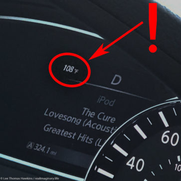
So far we’d endured the heat of the day, but it was beginning to take its toll on me. We forgot to re-ice the cooler back at Wall Drug, and we were in need of fuel. Rapid City by far had the cheapest gas prices along our route, so we just decided to take care of the car and the cooler at the same time. It was 3 o’clock, and the temperature had far surpassed the forecast high of 101°F—it was now 108°F and the prairie offered no reprieve from high winds sweeping the area.
When we stopped for gas, I spent a few minutes cleaning bugs off the windshield. By the time Becky came out with the ice, I knew it was urgent to get it in the cooler as quickly as possible or it would become a bag of water in minutes. Usually heat doesn’t get to me this bad, but I’ve never dealt with it in conjunction with the wind! My sense of urgency with the ice was intensified by my desperation to get into the Black Hills where trees would block the wind and altitude would dissipate the heat. My nerves were frayed and my energy gone. I didn’t feel like I could rest or relax until we found refuge from the oppressive prairie.
In the Black Hills at Custer State Park
About 20-30 minutes later, we were on SD-36 west of Hermosa and driving into the wonderful conifers of the Black Hills. By the time we reached US-16A and Custer State Park, the temperature reading was down in the mid-90s and the wind was nonexistent. We pulled into the entrance station and bought our week pass for the park for $20. This allowed us to stop at the new Custer State Park Visitor Center they’d opened since our trip in 2015.
The visitor center had beautiful interpretive exhibits about the geography and natural history of the park and the Black Hills. I spent some time talking to a volunteer there named Bonnie. She was super helpful and highly recommended the short intro film about the park that shows in the auditorium there. It’s narrated by Kevin Costner, and really is a well-done piece. It explores the array of activities and animals to enjoy in the park with some really breathtaking shots.
On to Bismarck Lake
By the end of the movie, I’m happy to say my sense of humor returned. I would love to have gone exploring, but I knew it was a bad idea. At this point, I just wanted to get to our campground, have dinner, and go to bed. We had a reservation just on the edge of Custer State Park at Bismarck Lake Campground in Black Hills National Forest.
We arrived there at 6 o’clock after dumping the water and re-icing our cooler again at Legion Lake Lodge just a few miles down US-16A. Our campsite was close to the entrance, perched atop one of the huge random rocks that are just everywhere throughout this part of the Black Hills. Since we’d stay here for the next three nights, we bought a bundle of firewood from the camp host. She informed us that we could gather dead and downed wood, but I didn’t have the energy for that.
Wiped Out
Unfortunately, I was also too wiped out to even build a fire. Once I helped Becky find the essentials for setting up our tent and beds, I set up my chair and just sat down to relax with some water. I wasn’t sure if I was suffering from a bit of dehydration or if the altitude of over 5,000 feet was bothering me. I just knew I needed to rest, because exertion kept making me feel worse. Everything I’d read about dealing with altitude said not to power through it—it only takes longer to feel better. So even though 5,000 feet usually doesn’t bother me, I just sat so I wouldn’t feel worse. I didn’t have to do anything to entertain myself…a rabbit foraged for a while around the edge of our site, and several squirrels were fun to watch too.
Becky made hamburgers on our little camp stove, and she fried up another pound of chicken breasts for tomorrow’s lunch. I wanted to get to bed early to try and sleep off this drained feeling. I was seriously concerned that today’s heat at Badlands would jeopardize our plans for the next couple days.
Adjusting Our Plans for Tomorrow
I originally planned for us to hike 6-10 miles to the summit of Black Elk Peak (7,244 feet) tomorrow and visit Spearfish Canyon on Tuesday. Since Spearfish Canyon was mostly driving with short hikes, I told Becky that I thought we should switch the days around. She completely agreed.
While Becky finished packing up after dinner and got ready for bed, I laid down at 8:30. The temperature had fallen considerably and the wind was still calm. Becky got into bed around 9. We let the breeze blow through our tent by leaving the rainfly open. We’d definitely need it later tonight, as the forecast called for scattered storms and a welcome low of 57°F. Hopefully a good night’s sleep would have me back to my old self in the morning!