RealImaginarySmokies Day 3 – Newfound Gap, The Jump Off & Clingmans Dome

After a late start, we made our way to Newfound Gap with a brief stop at Sugarlands Visitor Center. From Newfound Gap, we hiked the Appalachian Trail to the Boulevard Trail, and made our way to The Jump Off. After hiking back to the car, we made a short trip to Clingman’s Dome, and then made a quick stop in Gatlinburg on our way back to Elkmont.

Home Sweet Campsite

As forecast, our first night in Elkmont Campground was quite cold! The chill made it difficult to get moving any earlier than 8 o’clock this morning, just a bit after sunrise, even though we got to bed at a good time last night.

It was nice that this was going to be home base for several days! There weren’t many nights where we stayed put on our RealImaginaryWest trip last summer. I don’t mind moving around too much, but it is time-consuming to pack up the bedding and the tent, drive to the next location, and then unpack and set up again. Another problem with moving around is that we have to find firewood again if we move very far.

Fueling Our Fires

Firewood is something I try to be a good boy about, even though it’s a real pain sometimes. Campers like us have crisscrossed the country with firewood from home, sometimes spreading invasive pests like insects and fungi. These can and do have devastating effects on forestland. Ever since we started camping, we have always been diligent about acquiring firewood locally. It helps that our car is really only big enough for all of our camping gear and food. The times when it’s been really tempting for us to move firewood is when we’ve had some left over and we’re headed to camp in the next state. The rule of thumb I’ve seen is that you don’t want to transport wood more than 50 miles—but you may not be able to travel even one mile with it, depending on where you are—so you want to be sure! It’s totally worth the effort for us to know and comply with the law so that we aren’t responsible for the demise of the beautiful places we visit.

This year there’s a new regulation at Great Smoky Mountains National Park that requires that all firewood brought in must be heat treated and certified as safe by the USDA. The only other option for campers is to find firewood inside the park. Now back in Ohio, state parks tend to prohibit campers from gathering firewood. But when we were out West, we were allowed to gather dead-and-downed wood in Yellowstone and Grand Teton National Parks. They have the same rules here at Great Smoky Mountains National Park, so I brought my trusty sierra saw so we could save some money on firewood. Since this park is at a much lower and warmer elevation and in a much wetter part of the country, I knew it might be tricky to find dry wood that hasn’t already started to rot…but I was optimistic.

A Fence?

In my search, I made a strange discovery…I walked back into the woods directly across from our campsite, which took me up a hill…and to an old wire fence. I knew we were deep within the national park’s boundary, so it was strange that there would be a fence in a random area I figured for backcountry. After I found an opening, I saw that this was an old cemetery. I thought it was strange indeed to find a cemetery inside a national park, but Great Smoky Mountains National Park was created in an area that most definitely had to have had at least some settlement beforehand. While most were from the early 20th Century, a few were as recent as the past five years…further compounding the strangeness.

My curiosity wore off when my hunger reminded me that I was on a mission to gather wood to cook breakfast, so I walked out the gate on the gravel drive out of the cemetery and down a hill. I found several good small trees a short distance from there and cut a couple of long segments that I could drag or carry back to camp. I’d cut these up and we’d have more wood to supplement what we’d bought last night.

Checking In

Since we’d arrived after the camp office closed last night and our reservation tag wasn’t up on the after-hours board, I had no idea how to tell anyone we were here until this morning. While we were finishing up breakfast, someone came by and told us that we’d need to check in by 11. This seemed simple enough…

When I went down to the camp office and told them about my reservation, they scoured their printed lists and still couldn’t find me. I told them I booked on Saturday morning, but I didn’t have any way of pulling up the confirmation because I don’t have Internet service on my phone. I was surprised that they still used paper for all of this, seeing as reservations are all done by phone through a call center or online! Eventually they did find my reservation, and they set me up with a tag for our site. This stressed me out a bit, but everything was fine in the end.

Getting Out…Slowly…

I was really excited to explore the hiking options here at Great Smoky Mountains National Park, but I found the volume of possibilities overwhelming. Since we’d decided to come here so last-minute, the only preparation I’d managed before we got here was to find an online trail guide and cache a few of the descriptions on my phone. Unfortunately, collecting wood, cutting it, checking in, deliberating over what to do, and our slow and easy pace with breakfast this morning took up the first half of our daylight before we knew it. It was well after noon, and we needed to head out very soon if we were going to get any kind of a hike in before sundown at 7 o’clock.

The views along Little River Road from Elkmont to Sugarlands Visitor Center put the fall foliage on magnificent display!

I finally settled on a hike that departed from a trailhead at Newfound Gap. So we cleaned up our campsite, packed up the car, and headed out. Under ideal conditions, it was a 20-mile, 40-minute drive down Little River Road to Newfound Gap Road. It seemed easy-peasy, but this was when we first discovered how bad the traffic gets here! We decided to stop at Sugarlands Visitor Center, which is near the corner of the two roads. I never imagined that traffic backups could be so bad in a national park, but it took us at least 10 minutes or so to advance from being able to see the visitor center to being able to turn into its parking lot! The particular shame of the matter was that we had to get in line again in order to get back to Newfound Gap Road…cringe!

Not long after we hit the traffic jam, we came into the range of civilization and our phones began to explode with pent-up text messages. While I had only a few, Becky had tons from her friends about the Star Wars trailer the night before. One from Jenny was actually important though—last night, she was supposed to buy tickets for opening night in December—but she wasn’t able to because so many people tried at once that several ticket sites crashed! So we didn’t actually get tickets until today, but we did get them. While we were in the visitor center parking lot, we were able to get a strong LTE signal that allowed Becky to get the new trailer to play on her phone…so we finally got to see what we’d been waiting so many years for!

Anyway…this ate up even more time, and we didn’t get back on the road until 2:30pm…and we didn’t get up to Newfound Gap until almost 3 o’clock. This left just barely enough time for a good hike.. I figured we could get to The Jump Off, which is a 6 1/2 mile round trip, mostly to the east on the Appalachian Trail.

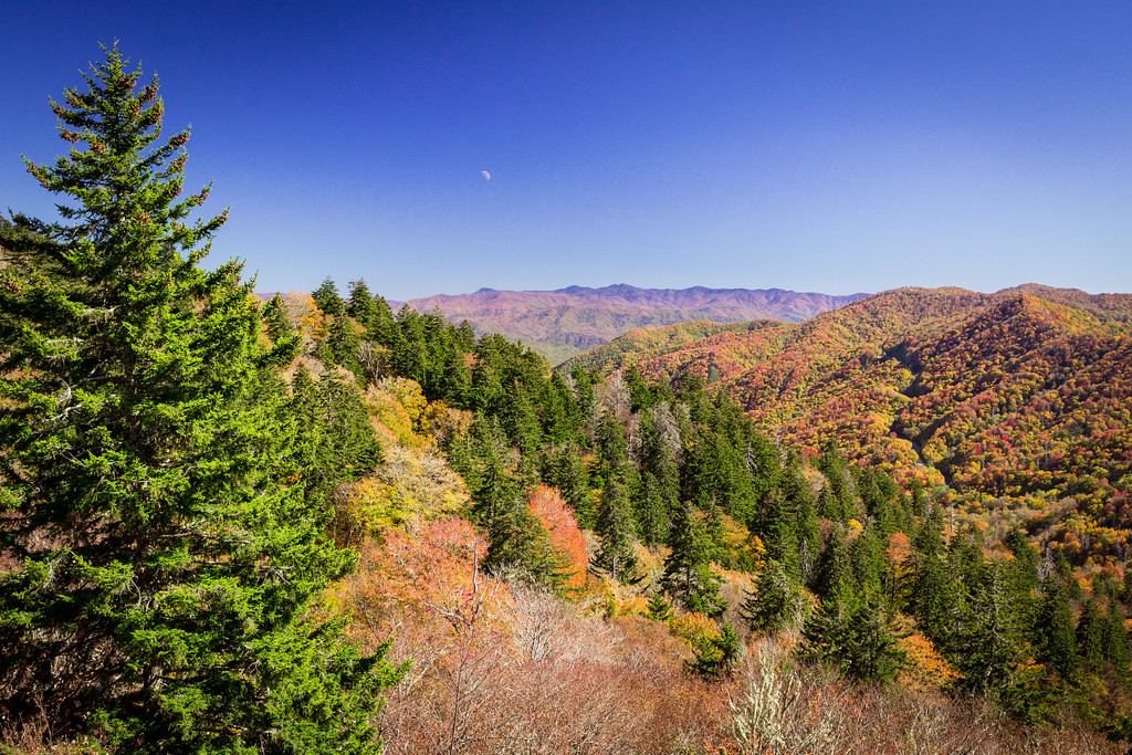
The Appalachian Trail to The Jump Off

The Appalachian Trail, often referred to as “the AT”, is a 2200-mile hiking trail that extends along the Appalachian Mountains from Springer Mountain in Georgia all the way to Mount Katahdin in Maine. Its route traverses Great Smoky Mountains National Park, with a major trailhead at Newfound Gap. We’ll hike on it for our very first time today, using a 2.7-mile section on our way to The Jump Off.

Looking east from the parking lot at Newfound Gap provided a splendid view of the colorful trees on the North Carolina side of the park, as well as the moon just above the horizon.

Becky poses before our first hike on the Appalachian Trail. It’s 1,972 miles to the end of the trail in Maine, but only 3.25 miles to where we’re going!

Continue reading RealImaginarySmokies Day 3 – Newfound Gap, The Jump Off & Clingmans Dome

RealImaginarySmokies Day 2 – Cumberland Gap & Camping in Great Smoky Mountains National Park

We continued south on US-23 into Virginia and cut west on Alt-58 and US-58 to Cumberland Gap National Historic Park, where Virginia, Kentucky, and Tennessee all meet. After enjoying the view there at Pinnacle Overlook, we stocked up on groceries in Knoxville and drove through Townsend into Great Smoky Mountains National Park, where we set up at Elkmont Campground.

In Search of Breakfast

We spent our first night on the road in a warm cozy room at the Eastern Heights Motel in Ivel, Kentucky. We were up bright and early at 6:30am and got on the road just before first light at 7:15am. An early high fog hung just over the hills, shrouding the tops in mystery. About a half an hour after we got going, the sun quickly burned it all off.

We decided to start our day by looking for breakfast. I preferred finding a mom & pop greasy spoon over a national chain place. I expected that there would be plenty of these along US-23, but I was hard-pressed to find any using Google Maps the night before…maybe they never got on the map? So we kept driving south along the highway, keeping our eyes open for prospects.

As we came up to Pikeville, about 10-15 miles from our motel, we decided to exit and search there in hopes of finding something. What I didn’t know is that Pikeville is a more sizeable college town. While there were large sports facilities, parking decks, and big-brand hotels, there was not much in the way of restaurants—especially for breakfast. On the main drag that appeared to be where the US highway used to snake through, we did find Roasted, Coffee and Cafe. However, I didn’t see any breakfast choices that appealed to me for the $5 price tag. So Becky bought her usual espresso and we continued south.

Eventually, we began ascending further and further up hills in the mountains until we went over Pound Gap and crossed into Virginia. Mom & pop dining options along the way were sparse, and we often missed them until we were about to pass them at nearly freeway speed…so it was after 9am and I was still quite hungry. Finally, near the town of Wise, we passed through a commercial strip area where I settled for Huddle House. While the food wasn’t super spectacular or super cheap, it did hit the spot so we could continue on our way.

Morning fog lingers over a valley to the south of Pound Gap.

It wasn’t far to the south where we finally diverged from US-23 at Big Stone Gap and started following Alternate US-58, which is known as Trail of the Lonesome Pine Road most of the way. We passed through several quaint little old valley towns with some beautiful brick buildings right up against the street. In Jonesville, the alternate leg of US-58 joins the mainline highway again and we began following the Wilderness Road. After we meandered our way through countryside and a few more hamlets, we arrived at Cumberland Gap National Historic Park.

Cumberland Gap National Historic Park

Now the Wilderness Road was one of only two good routes across the Appalachian Mountains into Kentucky (the other was the Cumberland Road, which later became part of the National Road that went across from Cumberland, Maryland). Daniel Boone was the man hired in 1775 to blaze a trail that opened up settlement in Kentucky, and that trail became known as the Wilderness Road. It crossed the mountains at Cumberland Gap, which is now the site of a national historic park run by the National Park Service.

Cumberland Gap had been used by Native Americans to cross the Appalachians long before the colonial era. After Daniel Boone carved his trail, it was later widened to allow wagon traffic to pass. It held a great deal of strategic significance during the Civil War, changing hands multiple times. When the US Highway System was created in the 1920s, Cumberland Gap carried US-25E. The Wilderness Road across Cumberland Gap was restored to its historic appearance as a wagon trail in 1996, when US-25E was rerouted through the new Cumberland Gap Tunnel.

Cumberland Gap Tunnel

Inside the Cumberland Gap National Historic Park Visitor Center

Fern Lake between the trees at Pinnacle Overlook

When we arrived, we passed back into Kentucky through this tunnel, and exited the highway to go to the Cumberland Gap National Historic Park Visitor Center. Besides taking a quick look around, I asked a ranger about which parts of the park were the best. It was already about noon, and we still had at least 2-3 hours to drive and a stop for groceries before we made it to Great Smoky Mountains National Park…so we didn’t have more than maybe an hour or two here if we were going to beat rush hour traffic out of Knoxville. The ranger said that hiking across Cumberland Gap doesn’t offer much to see besides the trail itself—but she definitely recommended that we drive up the mountain to Pinnacle Overlook.

So we set out on the winding switchback road up the mountain to a parking lot with ample space. Several short trails, including one that is handicapped-accessible, took us just over the Virginia state line to Pinnacle Overlook. The view here did not disappoint! You can see for several miles across a few towns, countryside, and forested hills to the south, including Tri-State Peak, where the borders of Virginia, Kentucky, and Tennessee all come to point, and tranquil Fern Lake. I spent a good hour photographing from the vantage point here, since it was a relatively clear day and lighting conditions were rather favorable.

Hey, a stranger we met snapped a decent picture of us!

Becky with one foot in each state on the trail back to the parking lot

Overlooking Tennessee and Kentucky from Pinnacle Overlook in Virginia…I will post a link to the full-res version (1.2 gigapixels!) when I get it uploaded…

Continue reading RealImaginarySmokies Day 2 – Cumberland Gap & Camping in Great Smoky Mountains National Park

RealImaginaryWest Day 13 – Grand Teton National Park to Craig, Colorado

After a boat ride and a short hike up to Inspiration Point at Jenny Lake, we depart Grand Teton National Park and Wyoming for Craig, Colorado. This takes us most of the way to Rocky Mountain National Park, where we head tomorrow.

Waking Up

After a few days at altitude slowly dehydrating me and making me feel like garbage each morning, waking up today was really easy. First light came, and my bladder reminded me of how much water I’d been drinking to rehydrate after yesterday’s visit to the hospital in Jackson. My bladder woke me up around 1:30am too. Oh the price we pay to stay healthy while roughing it…

More Wet

Once I’d returned from the restroom and was able to consider less urgent matters, I noticed our tent was covered with water droplets. I complained to Becky about how wet everything was still…and she informed me that it had rained again overnight. Grrr!!! That explains it! (I must have slept better than I thought!)

Since we had to pack up this morning, this was disappointing. It became downright frustrating when I realized that water was inside the tent again too, and that all of our damp towels left out to dry overnight were now quite soaked instead. I did not expect rain to be this much of a problem out West where summers (I thought) were mostly dry.

Most of all I was beyond irritated with our tent. Every time it rained, water got inside. I really expect any tent I own to do two major things: 1.) keep me warm, which this tent was not great at, and 2.) keep me dry…major fail. I came to find out later that you’re supposed to seal these things at least once a year. (You’d think they’d put that in the setup instructions!) And maybe it’s unrealistic on my part to expect a three-season tent to be all that warm.

Anyway, expectations aside, our Coleman Rosewood 4-person tent is a great starter tent. But this road trip did expose some weaknesses. It didn’t ventilate exceptionally well in the heat, but it also didn’t hold onto heat overnight. Also, the poles are made of fiberglass, and break easily even under extraordinary care—they’re also not easy or even possible to repair, and replacements cost almost as much as the tent. It also has a high profile which gets flattened by strong winds like we experienced in De Smet, South Dakota. Maybe we’ll look into an upgrade for next year…

So with a soaked tent and soaked towels, packing up was going to be a drag. I picked up the driest towel I could find and started wiping. I still saw water droplets. Our entire rainfly was also wet on the inside…condensation from our breath in the cold air. We could probably pack everything up now and dry it off in Craig, but I wasn’t fond of having a damp tent in the car all day long. Tonight’s rain potential had also inched up from 0% to 10%. Awesome. Ten percent seems to be all it takes this summer.

The best course of action seemed to be to leave the tent up to dry here for a few hours. This meant an extra hour of driving from Colter Bay to Jenny Lake and back from our hike, and tacking on an extra 30 minutes to our drive down to Craig. And checkout time is at 11am. Bummer.

Off to Jenny Lake

By around 7am we had everything but the tent packed up, and we were on our way to Jenny Lake for one last hike before leaving Grand Teton National Park. Yesterday the plan was to take the shuttle boat across and hike up into Cascade Canyon. Since we had a 6-7-hour drive ahead of us, we’d do an abbreviated version of that this morning. The shuttles run 10 minutes apart, so I guessed it must take just under 10 minutes to cross the lake. With a 30 minute drive back to Colter Bay and another 30 minutes to dry off and pack up our tent, I estimated that we needed to be on a boat back a little before 10 o’clock. This would give us about two hours to hike—not a ton of time, but hopefully enough!

Along the way, I saw a sign for North Jenny Lake and a scenic drive. I remembered seeing this one-way road along the lakeshore on the map. Being impulsive and curious, I decided to check it out. It was a pretty little drive with a few pullouts and OK views along the lake, but it wasn’t anything seriously impressive like I’d hoped. My mind was wandering anyway…I kept thinking about whether we shouldn’t see about a late checkout to give us a little more time on the trails.

The light was beautiful, so I couldn’t pass up a quick stop at Willow Flats Overlook to capture a high-resolution panorama. This can be printed HUGE, since the original is 24817 pixels x 8272 pixels. The low-hanging clouds looked so cool!

I also grabbed this shot with a clearer view of Grand Teton.

This ground squirrel foraged around the fringes of the parking lot at the Willow Flats Overlook.

Parking at the Jenny Lake Visitor Center was a breeze when we arrived at 7:50! Coming in yesterday just before 11am put us at the peak of the crowds. Of course, it was time for me to hit the restroom again. Becky also wanted to comb the gift shop one more time to find a “Jenny Lake” souvenir for her best friend, Jenny, back home. This would easily take us up to 8 o’clock, which is when the camp office at Colter Bay opens. Before we get on the shuttle and leave cellular range, I could call and ask for a late checkout.

Unfortunately, Becky came up empty again. They only had stickers and fridge magnets, and everything else had sold out. We did, however, get OKed for a noon checkout! Awesome! Now we’ll definitely have time for a good hike.

Taking the Shuttle Boat

Round-trip fare for the shuttle boat across Jenny Lake was $15 per person. This seemed pretty steep for a short trip, but when you figure in the remoteness and the short four-month tourist season here, it’s more understandable. It would definitely save us time, too, as it shaved a six-mile hike to Inspiration Point or Hidden Falls down to only two miles round-trip. What really sweetened the deal was that they also sold Jenny Lake water bottles at the docks—so we had more water, and Becky finally had the gift she wanted for her bestie!

A shuttle boat head back to the docks by Jenny Lake Visitor Center.

Becky enjoys the ride across Jenny Lake in the crisp morning air.

The lake was very calm. Winds here seemed to be calm overnight and intensify with the sun throughout the day. Becky said she heard that Jenny Lake is hundreds of feet deep, which would keep the lake from getting too rough for very long. This made for a smooth ride across. The overnight storm had also left behind some beautiful low clouds between us and Mt. Moran.

I was a little torn between hiking to Inspiration Point or Hidden Falls. The driver taking us across shared that Hidden Falls was an easier trail but had no view, while Inspiration Point has an elevation change of 600 feet over the course of a mile and an extraordinary view at the end. We probably could have done both, but the trail in between was closed.

I asked the driver how long it took to get to Inspiration Point, and he way very vague. It was pretty difficult to judge someone’s physical condition and acclimation to the altitude. He said it takes him about 30 minutes, and that most people should expect it to take at least 45 minutes. This sounded like it would work for our timeframe, which at this point was a little over 2 hours.

Continue reading RealImaginaryWest Day 13 – Grand Teton National Park to Craig, Colorado

RealImaginaryWest Day 12 – Too High & Too Dry at Grand Teton National Park

A late start put us in a bind for parking at the Jenny Lake Visitor Center. We were not here long, however, and we did not get to go hiking—but that had nothing to do with parking. Rather, we spent most of the day in Jackson after a visit to St. John’s Medical Center. We returned briefly to Jenny Lake late in the afternoon before heading back to Colter Bay Village. (Ignore the map for now…Google Maps is being dumb 😛 )

Travel Is a Learning Experience

Yes, folks, they say experience is the best teacher. On certain days of this trip, we’ve definitely had an experience that taught us something we’ll never forget. Back in South Dakota, we learned that it’s really nice to have a contingency plan if a thunderstorm rolls through when we’re camping on the Great Plains. Just a couple of days ago, I learned that my lack of planning can easily result in an overtired and unhappy Becky. And this morning, I learned something about spending time at altitude that I will never ever forget. I suppose the “they” who said that experience is the best teacher could also say that travel is the best way to gain experience.

Today’s lesson culminated this afternoon. I say culminated, because the lesson had actually started way back when we arrived in Yellowstone—I just didn’t know. Remember those headaches I’d mentioned over the last two days or so? Yeah, well I went to sleep last night with one, and it was still lingering when I woke up this morning. I’ll explain the connection in a bit…

Slow Start

Yesterday we left Yellowstone National Park and set up camp in Colter Bay Campground in Grand Teton National Park. It was a smooth and uneventful day beyond a little sightseeing. We spent most of the day relaxing and just setting up camp for the next couple of days. We even got to bed at a good time, about 10pm. Aside from the headache I went to bed with, I felt pretty good, and just chalked it up to our altitude at 6,800 feet. Becky too wasn’t feeling 100% herself. Either way, I thought a good night’s sleep would have us feeling better this morning, and we’d get an early start.

Well, we didn’t. I could have felt better, but I felt mostly OK. Becky wasn’t feeling all that great. So rather than arriving bright and early at Jenny Lake to take a shuttle boat across to hike Cascade Canyon, we slept in. This sounds nicer than it felt, since our air mattress was almost completely flat. Becky suspected a slow leak, but I thought tired batteries could also be the culprit. I think we finally got on the road around 10am.

The views of the Tetons along the way were incredible! The morning sun lit Mount Moran and Grand Teton in a totally spectacular and yet totally different way than we saw near dusk the night before. At this point I was totally engaged in the scenery and my photography, as usual…and my morning meh feeling was no longer on my mind.

Mt. Moran as we passed the Willow Flats Overlook, where we stopped last night on the way to Signal Mountain

Grand Teton dominating over the Teton Park Road and the Potholes Turnout

Arriving at Jenny Lake…Sort Of

We arrived at the parking area near the Jenny Lake Visitor Center and the place was completely packed. I knew this was a popular area, but I had no idea how much demand exceeded supply. As Becky drove around the parking lot hunting for a space, I began feeling more and more woozy. I’m sure winding around wasn’t helping, but my heart was starting to beat faster now too. After we passed Willow Flats I noticed I felt a little short of breath and used my albuterol inhaler which helps with my asthma. That can raise my heartbeat, but not usually this much. Things did not feel right and seemed to be getting worse. I told Becky that she had to stop the car. Since there were no parking spaces anywhere in sight, she was a little confused. I told her to just stop somewhere that cars could still pass, because I felt terrible and needed to stop moving.

Continue reading RealImaginaryWest Day 12 – Too High & Too Dry at Grand Teton National Park

RealImaginaryWest Day 11 – Old Faithful & Moving to Grand Teton National Park

Old Faithful was the last sight we saw in Yellowstone before we packed up at Grant Village and moved on to Grand Teton National Park. After we scored a campsite, we relaxed along the shore of Jackson Lake and had dinner. Our nightcap was a short drive up to the summit of Signal Mountain.

Waking Up to Rain… Lovely

After spending a lot of time cleaning and drying off our tent when we packed up at Canyon Village the day before, I woke up at 5am this morning in Grant Village to the sound of rain on our tent.

I was already plenty anxious about getting an early start and moving down to Grand Teton National Park today. I was especially nervous about moving because all of the campgrounds at Teton are first-come, first-served so we had no reservation. I wanted to be completely packed, go see Old Faithful, and then beeline directly to our next campground as early as possible. Having to dry a wet tent all over again could jeopardize getting our next campsite. Boy was I annoyed.

As the rain continued to fall and I continued to stew, I expressed my irritation to Becky. She told me that all that negative energy and anxiety did absolutely nothing to help us, and that it robbed me of enjoying things. “Roll with the punches,” she said. I realized she was absolutely right.

So even though the rain hadn’t stopped, I took my wife’s sage words to heart—I stopped stewing and started thinking. I suggested that we get up right now, go see Old Faithful erupt, and then hopefully come back after the rain to a dryer tent to pack up.

Becky dug the idea so we got up at about the same time the rain stopped. We shuffled off to the restrooms and got on the road at about 6:30am for the 35-minute drive to Old Faithful.

Old Faithful

The Grand Loop Road passes below the overpass for the Old Faithful Road.

Old Faithful steamed quietly when we arrived.

People begin to disperse after an eruption with the historic Old Faithful Inn as a the backdrop.

Old Faithful is by far the most famous and most popular attraction in Yellowstone National Park. The otherwise two-lane Grand Loop Road actually widens to four lanes with a freeway-style trumpet interchange that takes you into Old Faithful Village. It’s so strange to see such urban infrastructure inside such a wild and vast national park, but it makes sense to keep traffic moving in order to minimize air pollution in this pristine place.

Besides the geyser, Old Faithful Village itself is quite extensive. There are a few stores, restaurants, and lodges here, including the historic Old Faithful Inn. The visitor center sits only one or two hundred yards from the geyser everyone wants to see. We arrived here at about 7am and checked for the next predicted eruption time. Unfortunately, the visitor center doesn’t open until 8am, and the time posted in the window was from just after close the night before.

So we were here, but we had no idea when the next eruption would be…but I didn’t panic, since there weren’t any people gathered as if it was about to blow. Finally, I found a sign that said I could find geyser eruption predictions at @GeyserNPS on Twitter. I pulled out my phone and hoped for good cell service… Huzzah! The feed predicted the next eruption at 8:12am, plus or minus ten minutes. I also found out I could call a number for other geyser predictions.

To say that Yellowstone has geysers is an understatement. When we drove around the park yesterday, we realized that there are not just a few geysers, but that there are a few geyser basins that each have several geysers! Old Faithful is only one of many steaming holes in the ground that erupt hot water every so often in what is called the Upper Geyser Basin. So since we had plenty of time before we needed to stake out a particular spot, I called the prediction number to find out if any other geysers were expected to erupt nearby. It turned out that Daisy Geyser may be a possibility, so I made sure we picked a vantage point where we could see both in case they went off at the same time—how cool would that be!

A fun fact about Old Faithful is that it is not the largest, tallest, or hottest geyser. It is, however, the most dependable big tall geyser in the park. It has been erupting about every 90 minutes for years, with varying heights of a few dozen feet to 200 feet. While you can’t quite set your watch to it, its dependable vertical spectacle is how Old Faithful earned its name and its spot as the top attraction in the park.

Old Faithful at its peak during eruption at 8:05am on July 12, 2015

Old Faithful erupted for us right on time at 8:05am. I’d read that Old Faithful often “plays” a bit with smaller eruptions, but there was no play involved here. About a minute or two before water burst forth, the geyser bellowed much more steam. The water pushed higher and higher, and then stayed at peak height for about a minute and slowly died down into a tiny fountain. Finally the water stopped and the geyser returned to just a steaming hole in the ground.

We didn’t see Daisy erupt, but Old Faithful was very cool all by itself. It was time to get back to pack up camp and move on in time to get a campsite in Grand Teton. My first choice of campground was Jenny Lake, which was a good two hours away. I knew that was a longshot, but my backup campground at Colter Bay wasn’t much closer, and I was nervous both could fill by noon.

Continue reading RealImaginaryWest Day 11 – Old Faithful & Moving to Grand Teton National Park

RealImaginaryWest Day 10 – Grand Canyons, Geysers & Grant Village in Yellowstone

After packing up camp at Canyon Campground, we hiked to the brinks of Lower and Upper Yellowstone Falls and had a late lunch at the Canyon Lodge Dining Room. We then took a drive to Norris via Virginia Cascades and drove the southwestern section of the Grand Loop Road on our way back toward our new campsite in Grant Village.

Sleeping In (Sort Of)

Even though I didn’t get to sleep until midnight last night, I still woke up at dawn, this time with a headache. I get those sometimes, mainly from muscles in my back and neck being messed up by car accidents and too much sitting for work. Usually I apply pressure in the right places and my headache subsides, but today that wasn’t working for some reason…so I just took it slow and endured the pain.

I looked over at Becky, still sleeping. Yesterday we got up at 5:30am, but I had kept us go-go-going so much that we got to bed too late to do it again today. Becky needed recovery time, and I was glad to see her getting it. She and I were both up and about around 8am. I started a fire so we could have a real breakfast and so Becky could make some real coffee. I also took the opportunity to set up my pano rig so I could get a 360 shot of our campsite.

This was just not our morning though. The late morning lighting conditions weren’t working for me, and I kept forgetting steps in creating my 360 shot. Becky’s campfire coffee percolator got too hot on the fire and the handle melted. Our frustrations were getting the better of us. My headache still lingered. We still had a lot of packing to do. And I still hadn’t talked with Becky about how to avoid a repeat of yesterday’s Yellowstone Mania. All this anxiety got us super grumpy, but things were good once we let each other chill out for a few minutes. Once we really got to packing, the day got steadily better.

360-degree panorama of Site J193 at Canyon Campground in Yellowstone National Park. Despite my frustrations, this actually turned out well! Click and drag to look around & click the arrows to see a different location. Click the top right button to go full-screen.

Packing Up at Canyon Campground

This pack-up was messier than the last one though. It had rained quite a bit while we were out yesterday. We got some water inside our tent, but by now everything was dry. The outside, however, was still wet in spots and the tarp underneath was completely wet with tree debris stuck all over it.

This is where I’d like to leave an endorsement for a $2.07 hand broom and dustpan set I bought over 15 years ago when I moved into my first apartment. It wasn’t great for sweeping my kitchen floor back then, but it works perfectly for so many things when you’re camping! Every time we pack up the tent, I use it to sweep all the fuzz and debris on the floor. I use it to brush off all the bugs, needles, and leaves on the outside of the tent. I can even use the brush to help my tent dry faster by spreading out the water beads.

Unfortunately for my trusty dustpan, I overestimated its abilities. When we arrived, I used it to shovel ashes out of the center of our fire ring and it worked great. I actually made a pile of them next to the ring so I could use them if I needed to put out a fire. Unlike back East, it’s very dry throughout much of the West, making everything from the grass to the brush to the trees quite flammable. As a result, campers are instructed to extinguish all fires before they leave their site or go to sleep for the night, either by dousing with water or covering with dirt. After cleaning out the tent, I thought that I better shovel those dry ashes from our first night onto the fire to put it out. Easy peazy, right?

Well, the rain had soaked my dusty ash pile and turned it into something more like hard clay. I didn’t expect this, and so I dug in hard and shattered my faithful dustpan. 🙁 I was so angry! I still needed this thing for the rest of our trip, and now it was broken. Becky doused the fire with water after this fail, leaving a pool of boiling water but no smoldering ashes behind.

OK, so maybe it was actually after we put the fire out that the day really started to improve. One of the last things we packed up was our tent and tarp. As I folded each part of the tent, I used the hand broom to clear off the tree junk and a towel to wipe it dry. For the last little bit, Becky just held the tent up for me while I brushed and dried it. After the tent was neatly in its bag, I swept off the picnic table at the vacant campsite next to us and draped our tarp over it so I could brush off one side. I then folded it in half to brush debris off of the other side and off the table again. Then I flipped the tarp and cleaned the other side. Finally, I had a relatively clean, dry tarp to fold and put into its bag.

So on a big or a little trip, never underestimate the usefulness of a good hand broom and dustpan!

Back to Yellowstone Falls

Ravens were a common site anywhere they could find scraps…either from humans or other animals in the park.

Now that our campsite was packed into the car, we drove out to the main road and back over to the parking area near the brink of Lower Yellowstone Falls. It was a late start for us, arriving about noon. I wanted to hike in and see more of the canyon, including the Upper Falls. I popped open the trunk and began rummaging through my photo bag, thinking of which pano head and lens to bring.

That’s when I remembered the day before and said to myself, “Screw it! I’m tired, and I need to just relax and have some fun, and stop trying to be a documentarian for every hour of the trip.” I decided I’d bring my camera and only my 24-70mm lens, which is plenty versatile and won’t get me too hung up shooting panos.

I informed Becky of my decision. She smiled and replied, “I like ‘Screw It’ Day!”

She thought it was cool for me to grab a camera and shoot stuff, but that the day be more about us and less about the ‘photo shoot’. I liked the sound of it too.

A Bug’s Life

Before we got going, Becky made preparations sitting in the passenger seat of our car with the door wide open. While she was looking down intently, I saw this big black bug with giant antennas land on the dashboard almost directly in front of her! In a hopefully unstartling tone I told her, “You might want to look up, there’s a big black bug in front of you.” She sorta freaked out and slowly backed out of the car. I was in no position to reach it. It stayed where it landed for the most part. Becky grabbed a map and tried to scoop it away, but it crawled deeper into the car! It stopped in a little nook on the side of the center console, but it was dangerously close to crevices where it could hide behind the dashboard. This required a better approach, or this thing was going to die somewhere back there and possibly stink up the car (glad it wasn’t ours).

Becky acted fast and cut the top off a big empty water jug we hadn’t yet thrown out. She then easily scooped him up and let him go outside of the car. We kept the scoop in case we needed it again. The bottom of the jug fit a loaf of bread perfectly, so we used it to protect our bread from getting smashed in the back. So I suppose you could say she killed two bugs with one jug!

Brink of the Lower Falls

People gathering to look down from the brink of Lower Yellowstone Falls

It’s a 600-foot drop but less than a half-mile hike to get to the top of Lower Yellowstone Falls. This area was far more congested than anywhere else we’d hiked so far. We could definitely tell this was like the Disney World of national parks with the casual manner in which several people took the paved trail. I had three people nearly collide with me on the switchback down, and Becky just missed getting hit in the face with a selfie stick.

In spite of the number of people and the rudeness of a few of them, the top of the falls was incredible! It’s amazing how fast the water moves through the upper canyon toward the Lower Falls. The sound of the water was just enormous. And the view of the canyon with a partly cloudy blue sky above was just awesome and unforgettable!

The Grand Canyon of the Yellowstone River from the brink of the Lower Falls

Continue reading RealImaginaryWest Day 10 – Grand Canyons, Geysers & Grant Village in Yellowstone

RealImaginaryWest Day 9 – Hot Springs, Overlooks & Oversights in Yellowstone

Our first full day in Yellowstone took us to Tower Fall in the morning and Mammoth Hot Springs at midday. We grabbed lunch outside the park in Gardiner, Montana, then found some wood and a moose on our way back to Canyon Village. We closed out the day at the Grand Canyon of the Yellowstone River and ate a late dinner back at camp.

Our First Full Day

Has a full week already past? Are we only on Day 9? Just yesterday I told Becky that 1 week and 2 hours ago (because of the time change) we left! It also doesn’t seem possible that today was Friday and that we still have more than a week to go…wow…we planned all this??? I don’t know how we did it, but I know we could only have been this successful from working together! I know I couldn’t have done this as well without Becky!

Today’s entry starts with the end. Right now I’m sitting at a biggole fire that took longer than I hoped to build, but I’m feeling content that I am warm, our tent is still good, we haven’t run out of money, and we are doing OK. It’s been tough sometimes and we’ve gotten in each other’s hair occasionally, but we have really enjoyed ourselves over the last week. We’ve learned a lot, and we’ve gotten to see a lot of the country!

I feel like we’ve done really well so far, but today I know my “OMG Yellowstone!” mania pushed Becky way too far. We were up at first light this morning in time for sunrise. We were out before the tourists wake up to clog all the roads and scare away all the animals. And then we ran almost all day without much downtime. It’s almost midnight now, and we still aren’t quite in bed. The original plan for tomorrow was to start early like we did today, but I know I ran Becky ragged, so I doubt it will work out that way.

Enduring the Cold

Let’s rewind and go back to how last night went. Becky was super cold, and had to cover her face with the top in-between blanket. It was by far the coldest night we’ve ever slept in. We’re up around 7,900 feet in elevation here at Canyon Campground, which means the atmosphere is much thinner and the temperature in turn stays much colder—often only in the 60s for a high and down into the 30s at night, even in July. By contrast Mammoth Campground, near the park’s North Entrance, sits at about 6,200 feet and experiences temperatures that are roughly 10 degrees warmer. I was concerned about whether we’d get rain or wind on top of the cold at night, but thankfully the winds calmed after dark and it only rained during the day.

Layers are key to beating the cold. Becky and I both wore at least 2-3 layers up top, and I had two on the bottom. We had two blankets between our sleeping bags and our air mattress to insulate us below, and then another one inside the sleeping bags to keep us warm on top. Without the extra blankets, we would have been unbearably chilly! But as it was, everything was rather comfortable for me, so long as I kept my hoodie up to keep my ears warm.

Yellowstone Mania

Steam rises from Wabash Hot Springs at sunrise.

Tower Fall

The Yellowstone River as it passes out of its grand canyon

Now I wanted to be up early enough to get some photos of sunrise at Yellowstone Falls, which is very close to our campground. Becky agreed that she’d get up at 5:30am and we’d be ready to go at 5:45. We got going right on time. The weather was definitely brisk, but the mostly cloudy sky looked to make for interesting images so long as the clouds didn’t completely block out the sun. After shooting the falls, we planned to go back to camp to shower up, then hit Mammoth Hot Springs and come back to camp again for early dinner and maybe a nap. Later, we’d go back to Yellowstone Falls in time for sunset.

When we drove out to Yellowstone Falls, however, there was a thick blanket of fog over the entire canyon :-(. This would not do, and I wanted to take advantage of the early light, so I decided we’d upend everything we’d planned and drive an hour to Mammoth Hot Springs right away. My mania had kicked in, and it wasn’t even 6am…

A few miles down the road from Canyon Village, we stopped at the Wabash Hot Springs Overlook, since it looked like our last good opportunity to take advantage of the sunrise. As I set things up, it was awesome to watch the sun cast its first light on mountains that had to be miles and miles away.

Things were starting to warm up, but my stomach started asking for food and Becky started asking for coffee…so we stopped by the Tower General Store. It was too early for it to open, so we made use of the time and hiked the short trail to 132-foot Tower Fall.

Continue reading RealImaginaryWest Day 9 – Hot Springs, Overlooks & Oversights in Yellowstone

RealImaginaryWest Day 8 – Buttes, Sulfur & Bear Traffic in Yellowstone

After packing up at the Ponderosa Campground, we got breakfast and hung out a bit in Downtown Cody. Then we stopped by the ginormous Buffalo Bill Center of the West—which was way way bigger than we expected! Next, we drove into Yellowstone National Park, making a quick stop at the Lake Butte Overlook to watch a thunderstorm across Yellowstone Lake. Lastly, we got stuck in bear/bison traffic near the Sulphur Caldron and Hayden Valley on our way to camp at Canyon Campground. This taught us that carpe tempore is the rule when passing restrooms…or trees……

Calm Night in Cody

Today we go from roughly 5,000 feet in elevation at the Ponderosa Campground in Cody, to 7,900 feet at Canyon Village in Yellowstone National Park. Altitude tends to catch up with flatlanders like us above 7,000 feet—also the days and especially the nights are much cooler…eek!

The sun was up around 6am at the Ponderosa Campground, and so was I. We were both fairly well-rested thanks to the calmness of the night. Not only was the weather perfect, but our 60 young neighbors from Teens Westward Bound were awesome too. It was clear that this was a great group of kids! At 6:30 they received their wakeup call from the trip captain: “It’s time to get up, little darlin’s!” she repeated kindly in her North Carolina accent, walking about the camp. I got a chance to talk to her later and ask a few questions. I was especially interested in how they handled inclement weather, as De Smet a few days before was still fresh in mind. They all camped out in the open on tarps and sleeping bags, which meant even less shelter than we had in our tent.

She explained that they had about a week left on a 23-day road trip. They were headed back home to Charlotte, North Carolina through the Black Hills and Mount Rushmore, after already touring the Southwest and California. Young people are not selected willy nilly for this program—these were responsible, academically successful youths. The group from the looks was about 70% girls and 30% boys. Everyone was taught to tarp up properly so that nobody got wet or blew away. The whole purpose of the trip, besides seeing the Western United States, was teaching each and every one of them, from high school sophomore to entering college freshman, that they could do pretty much anything they set out to do!

From what I could see, that thought had sunk in. The group was two weeks from leaving home, and they each awoke without a complaint, in spite of possible homesickness, and even if some of them looked like they could have used a couple more hours asleep.

It was time for Becky and I to get started too. We got in rather late and very tired from the big day’s drive from Rapid City and the rodeo the night before. I was so tired I didn’t even get a chance to take advantage of the electricity available here to dump my camera’s memory cards and charge a few batteries. So I took care of that while we packed up the tent. We got ourselves to breakfast at around 7:30 or 8am.

A Few Hours In Cody

Clouds rolled over Rattlesnake Mountain toward the historic buildings of Downtown Cody early in the afternoon. Peter’s Cafe is on the right about halfway to the first traffic light at 12th Street.

Becky picked out this place in Downtown Cody called Peter’s Cafe & Bakery. All of Downtown Cody is very well put together, with plenty of historic architecture along its spacious main street, Sheridan Avenue. Peter’s was in one of the old buildings here, with a standard American breakfast menu at reasonable prices. The bacon strips were huge and everything on our plate was cooked perfectly. They had a couple of book racks with great titles for customers to read while they eat, like How to Stay Humble When You’re Smarter Than Everybody Else, The Joy of Being Broke, and the one that first caught my eye, How to Share a Bad Attitude, all by Ben Goode. Hilarious stuff! I’m gonna have to check this out more when I get home.

Before we left downtown after breakfast, I shot a couple of panoramas and Becky perused some shops. We have plenty of charming old business districts like this back in Ohio, but few are this large and vibrant—and of course none have the Western flair of Cody. I particularly liked 12th & Sheridan because of the Irma—the hotel opened by Buffalo Bill Cody himself back in 1902.

360-degree panoramas of the central business district of Cody, Wyoming. Click and drag to look around & click the arrows to see a different location. Click the top right button to go full-screen.

Buffalo Bill Center of the West

The humble South Entrance understates the magnificence and expansiveness of the Buffalo Bill Center of the West.

Before we left town, we followed a tip to check out the Buffalo Bill Center of the West. We went into the small South Entrance to pay admission, and found out that this museum is so extensive that each ticket is actually a two-day pass! We explained to the lady at the front desk, Rosalee, that not only would we not be here for two days, but we really only had two hours at most before we drove to our campground in Yellowstone National Park. She was very kind and offered for us to take a few minutes to look around without charge, in order to get a feel for all they had there so we could plan to visit on our next trip.

Let me tell you, this museum is first class, and it is huge! It is actually five museums in one. The Draper Natural History Museum explains the geology, animals, and everything else on the prairies and in the mountains of Wyoming. The Plains Indians Museum shares the history of the native tribes who inhabited the West and the effect of United States settlement. There is of course a museum about the life and legacy of the town’s namesake, Buffalo Bill Cody. They also have the Whitney Western Art Museum and the Cody Firearms Museum as well as special exhibitions. The current exhibition was a firearms loan from the Smithsonian, way back East in Washington—which felt a world away after spending a week in the West.

I’d heard the Buffalo Bill Center was a great museum, but that was an understatement! I had no idea it was on par with museums in big cities like New York or Chicago. Everything I saw here was impressive, and certainly a bargain for the price. Next time we pass through Cody, we’re certainly spending quality time here.

Before we left, I shot a couple of 360-degree panoramas outside, including the Main Entrance where the statue of Buffalo Bill stands. Afterward we re-iced the cooler and refueled to head into Yellowstone.

360-degree panoramas outside the Buffalo Bill Center of the West. Click and drag to look around & click the arrows to see a different location. Click the top right button to go full-screen.

Heading Up To Yellowstone

It was just after 1pm when we left Cody, and the weather was transitioning from morning blue skies to early afternoon storms. US-14/16/20 is designated as the Buffalo Bill Cody Scenic Byway from Cody to the East Entrance of Yellowstone National Park. Almost the entire route follows the Shoshone River through the Absaroka Mountains, passing by Buffalo Bill Dam, its giant reservoir, Buffalo Bill State Park, and eventually through the Shoshone National Forest.

Just outside Cody, the US highway enters Shoshone Canyon, snakes its way along the river, passes through three tunnels, and finally emerges just past the dam next to the Buffalo Bill Reservoir. The reservoir provides irrigation for agriculture throughout the area. It’s really gorgeous here, even on a rainy day! There are tall mountains all around with gentle brown and sagebrush prairie sloping gently upward from the lake. There were beautiful houses perched partway up the mountainsides with what I’m sure were spectacular views of the river and reservoir amid the mountains. Most land around the north side of the reservoir was part of Buffalo Bill State Park.

Beyond the reservoir, we passed into Wapiti Valley. There are plenty of guest ranches and campgrounds along the highway here that no doubt take advantage of their proximity to both Yellowstone and Cody. After a relatively straight shot from the reservoir, the valley narrows into a canyon and the road begins to wind as we enter Shoshone National Forest and the heart of the Absaroka Range. The road hugs and criss-crosses the North Fork of the Shoshone River for several miles…

Shoshone Canyon, just downstream from Buffalo Bill Dam

We got excited as we approached these two tunnels…but before we knew it, we’d already passed through more than one tunnel. When we realized another tunnel was hidden in between…we got really excited!

US-14/16/20 along the north shore of Buffalo Bill Reservoir

Driving toward the western end of Buffalo Bill Reservoir and Wapiti Valley

Just inside the Shoshone National Forest near Wapiti Wayside

And finally we saw the sign for Yellowstone National Park! At long last I had been able to achieve a nearly life-long dream to tour one of the largest, finest, most renowned parks in the world! It had taken me almost exactly 38 years to finally make the trip. Almost exactly 7 years ago I made it to my first big western national park, Yosemite, and it was positively magical! I’d hoped that Yellowstone would prove to be in its own way just as majestic, profound, and inspiring.

Entering Yellowstone National Park

The East Entrance gate at Yellowstone National Park. The entrance fee here gets you into both Yellowstone and Grand Teton National Parks. Alternatively, you can get an Annual Pass like the one we bought back at Badlands National Park that gets you into all of the parks for an entire year.

The first thing I thought about when we reached the East Entrance was that it was very quiet! I expected a lot more traffic, especially in the middle of July. Maybe everyone entered through the North Entrance from Montana or flew into Jackson and entered from the south? I was pleasantly surprised to see that the park was mostly uncongested…and I was happy to know that there was a nice little campsite waiting for us in Canyon Village.

Stone guardrails like this one on the East Entrance Road line the steep edges of most roads in Yellowstone, rather than the metal ones typically used. A park should look prettier anyway, right?

Along the way in, you pass deep into virgin mountains, with the only evidence of the hand of man being the road you’re traveling. Rather than standard metal guardrails, most roads here have stone guardrails that remind you that you’re in a national park! After emerging from the giant mountains of the Absaroka Range, the view opens up and you catch your first sight of Yellowstone Lake. The lake was much much larger than I expected it to be, and the terrain around more mountainous. I don’t know why I expected something smaller…maybe it’s because any video I’ve seen just can’t do this place justice.

The entire landscape is covered mostly with sloping grasslands and forests, with occasional rock outcroppings. This was unlike what I saw frequently in the Sierra Nevada, where bald domes and half domes of sheer granite accompanied by spires decorated the landscape like a castle or cathedral.

Just 16 miles to our campground at Canyon Village! No problem, right!?

We stopped along the way at the Lake Butte Overlook, several hundred feet above the shores of Lake Yellowstone. We got an awesome view of an afternoon thunderstorm making its way down mountains on the opposite side of the lake. The area all around has obviously been burned out by a forest fire in the last few years. It felt like a worthy place to first set foot in Yellowstone National Park. After a few moments to look out and around and shoot some panoramas, we headed back down to the East Entrance Road. The road runs right below the overlook and along beaches on the lake’s north shore before coming into Fishing Bridge. We had some rain down along the beaches just before we caught the Grand Loop Road north to Canyon Village.

360-degree panoramas of the Lake Butte Overlook in Yellowstone National Park. Click and drag to look around & click the arrows to see a different location. Click the top right button to go full-screen.

Traffic Was a Real Bear

Who knew a few animals could cause such a stir?

I was able to fill the frame with this bison, it was so close to the road.

Along the road to Canyon Village, bison and elk grazed peacefully in the meadows. Motorists also sat peacefully with their cars, as we ran into our first traffic jam. So much for the park being uncongested! I knew going in that girdlock was fairly common in Yellowstone, and that it usually had nothing to do with bad driving. More often than not, traffic snarls because animals are close to the road, so massive amounts of people stop to take a look and get pictures. Sometimes the animals are on the road—and there’s no coercing a 2,000-pound wild bison to keep moving—so you just have to wait for them to cross. This traffic jam was stop and go for what seemed like miles though…so something big must have been happening!

Continue reading RealImaginaryWest Day 8 – Buttes, Sulfur & Bear Traffic in Yellowstone

RealImaginaryWest Day 7 – Devils Tower, the Bighorns & Our First Rodeo

The most driving we’ve done since Day 1 started in Rapid City, South Dakota. We took the scenic route through the Northern Black Hills to Devils Tower. We then took I-90 to Buffalo, where we followed the Cloud Peak Skyway/US-16 over the Bighorn Mountains. We continued on US-16/20 West from Worland, through Greybull, and on into Cody…where we camped before heading into Yellowstone National Park the next day.

Devils Tower & The Northern Black Hills

We made it! This far…

Up and off we went around 7:30am from the M Star Rapid City on Mount Rushmore Road/US-16. The weather was still a bit hazy, but it was probably the clearest morning we’d had on the entire trip. We got started a little later than we’d hoped, but we figured we still had time to hit Devils Tower and make it to Cody in time to set up camp and see the famous rodeo there. After finally remembering to clean the bugs off the windshield, we followed I-90 up to US-85, and then followed SD-34 across the Wyoming state line. Here, the road turns into WYO-24 and heads to Devils Tower. We could have stayed on I-90 and taken a faster route via US-14, but these three roads were all marked scenic.

Becky and I had already decided yesterday that what we’d seen so far of the Black Hills was pure awesome! We’d love to come back and camp either in Black Hills National Forest or Custer State Park. Seeing it for a day made us want to come back for a week! However, Devils Tower and what we saw of the Northern Black Hills in Wyoming made it hard to imagine confining a return trip to only the better-known Southern Black Hills in South Dakota.

At the last second I almost decided to stick to faster highways in the interest of time. After we got a few miles into Wyoming, though, I was so glad that we took the scenic route instead of the freeway! The red rocks and canyons along the Belle Foursche River held a type of beauty we saw nowhere else in the Black Hills. It was definitely worth the extra few minutes! Then we passed over a crest and around a curve—and caught our first glimpse of something like a giant tree stump on the horizon—that was just unmistakably Devils Tower.

It wasn’t the clearest day…but this was where we first laid sight on Devils Tower from WYO-24, still over 13 miles away as the crow flies. The hills on the right are the Little Missouri Buttes, which are just 3-4 miles northwest of Devils Tower and of the same geological composition.

Red sandstone is exposed along much of the Belle Foursche River as it runs below Devils Tower.

Devils Tower as seen from the east on WYO-110. Each angle offers a unique view.

It’s no wonder the Sioux and Kiowa saw it and thought, “This means something! This is important.” (Sorry, couldn’t resist!). The Kiowa have the coolest story about what Devils Tower means. The story is told in Ken Burns’ documentary, The West, and they had a display about a similar legend.

I can’t help but feel a sadness about the cultures that were destroyed by the United States’ westward expansion. The Indians really loved the land, and all the creatures that lived in it (at least when they weren’t warring with rival tribes). While the new Americans certainly intended on leaving their imprint on the West, often for the love of power and riches—they at least saw that places like Devils Tower should be held sacred, just as the Indians thought they were. And thus in 1906 with the passage of the Antiquities Act, President Theodore Roosevelt created Devils Tower National Monument—the country’s very first national monument.

While photography is all about capturing light, creating dramatic images is all about the shadows—and even in the middle of a hazy summer day, Devils Tower delivers from this northwest view! I can’t wait to see this printed on glass or metal…!

One last shot from the west, taken from the visitor center

At the visitor center, there were lots of ranger-lead activities and several hiking trails around the mountain that I would love to have seen. There were plenty of gorgeous campgrounds in the area too, within the national monument land as well as all up and down the nearby Belle Foursche River. Unfortunately, we didn’t allocate much time here in favor of more time at Yellowstone—and we needed to get going in order to make Cody. So on we pushed to US-14 and I-90…

Continue reading RealImaginaryWest Day 7 – Devils Tower, the Bighorns & Our First Rodeo

RealImaginaryWest Day 5 – The Good & Badlands of South Dakota

We drove through drizzly conditions from De Smet to Mitchell in Eastern South Dakota, and then traversed most of the state on I-90 to Badlands National Park and Wall.

Last Stop with Laura

So, after another violent Great Plains storm (albeit in much more secure conditions) and our car already packed, we emerged from our covered wagon to much cooler but drizzly weather. The misty haze was not looking good for my photographic aspirations today! The forecast showed the rain holding on for just a little longer in De Smet, and that there would be a general clearing trend where the sun might come out and burn off the fog.  Becky and I each got showers this morning, since it would have more long-lasting effects than if we’d showered the night before with the 85-90 degree heat and humidity. The humidity in South Dakota was nowhere near as high as what we had experienced before we left Ohio, but it was enough to make you move a lot slower so you didn’t overexert yourself in the heat.  Now that the temperature had dropped to 65-70 degrees, everything except the haze was peachy.

We got a fairly early start, getting out of the Ingalls Homestead around 8am. We headed into De Smet and to the local coffee shop, Ward’s Store.  Interestingly enough, this was the site of Charles Ingalls’ store, and in the original building that rose in its place after he sold it and moved out to his homestead.  Becky was really glad to have gotten coffee here, since now she’s been to every place where Laura lived in De Smet.

We then continued south on SD-25, making our way down to Mitchell, which is only about an hour away. We planned to see the famous Corn Palace, and I hoped to score a quick breakfast.  Ever since we’d left De Smet, it had been horribly foggy, drizzly, and hazy.  The rain had let up completely by the time we’d reached Mitchell, but the fog lingered.

The World’s Only Corn Palace

A look south down Main Street in Downtown Mitchell

We got breakfast at a hip restaurant called Cafe Teresa. The place seemed to be loaded with college students, who I’m assuming were from Dakota Wesleyan University. It was easy to overhear bits of conversations about finals, classes, and professors. Becky and I both ordered eggs and toast, which hit the spot..and so off we went to see the Corn Palace.

The Corn Palace wasn’t quite itself on the day we visited… This made us sad. 🙁

It was still way cool to see the corn murals though! 😀

The Corn Palace is the main tourist draw in Mitchell, which has about 15,000 residents and a rather quaint and decidedly Western downtown. The building is decorated on its exterior by thousands or maybe millions of ears of corn, color coordinated to depict western scenes of cowboys, buffalo, stagecoaches, and Indians on the front and sides of the building. Unfortunately, it took us a bit to make sure we had actually found it because it looked much less flamboyant than the pictures we’d seen. Apparently they were in the process of replacing the domes on top and had run into a delay because the new domes weren’t strong enough to hold up to South Dakota’s wind (which Becky and I have noticed is quite substantial).  Also, it appeared that they were updating parts of the building’s exterior, which they do every year anyway because it’s probably a good idea to slap a fresh coat of corn on the building to keep it from peeling.

So it’s that kind of palace!

Becky and I proceeded inside “The World’s Only Corn Palace”, hoping for a more satiating indoor experience. There were lots of exhibits inside about corn, the history of the Corn Palace (reaching way back into the 1890s), and then there were doors…turns out through the doors you could see that the Corn Palace had a lot in common with San Francisco’s Cow Palace and the Detroit Area’s Palace of Auburn Hills—for it was a small basketball arena where a giant souvenir and gift shop had been set up.  I didn’t figure it for an opera house, but I have to admit that without having done any research that in the back of my mind when I saw the general shape and size of the building, I wondered if in fact this was a basketball arena.

It seemed like a very nice place to see a game. It was likely that it hosted games for either the Dakota Wesleyan University or the local high schools.  But either way, the clock was ticking and we had to move on to Badlands National Park, which was about 3 hours away on I-90.

You GOTTA SEE South Dakota!


A VERY small sample of the gimmicky advertising…I regret that I did not capture more of these sorts of things!

I’d like to take this opportunity to recognize South Dakota for a couple of things. First, Mitchell was my first indication that South Dakota really was a great place to analyze advertising gimmicks, because between what we saw here and what we saw later that day in Wall, it was readily apparent that South Dakota took the art of a tourist trap to a refined art form!  There were signs and buildings and old trucks and cars and dinosaurs in front of billboards all along the interstate that really were sights in their own right and really made it tempting to stop a lot along the freeway and check this stuff out.

No, your eyes do not deceive—the speed limit really is 80mph!

Second, the speed limits in South Dakota often seemed to actually make sense!  In Minnesota and most other states, you drove 55mph, maybe 60 if you were lucky in remote two-lane state highways—we hit the SD state line, and voila—65mph!  When we first got on I-90 in Mitchell, we had to check our eyes at first—”Speed Limit 80″—AWESOME! So thank you, South Dakota, for admitting that you might as well be able to drive fast on the roads here because there are so very few cars, the visibility is great, and it takes so very long to reach someplace.

Another reflection I have to make about South Dakota is that I didn’t expect it to have so many trees—in fact, I didn’t expect it to have any at all without at least a creek nearby, since it is in the Great Plains—and the Great Plains is a great big huge prairie that just doesn’t have the rainfall to really grow trees.  Apparently the main reason why there are so many trees is because of the Homestead Act, which allowed you to earn your 160 acres of land through growing enough trees on your claim…and probably because people who aren’t used to vast open grasslands prefer to have lots of trees to break up the scenery (and did we mention wind?). Personally, I’m all about diversity and history, so I was excited at the prospect of seeing a land that was just covered with prairie and all the things that come with it!  I also think a giant prairie sounds awesome for just grazing cattle, which we saw a lot of actually. Black Angus cows were everywhere, and lots of pieces of property up in the northern part of the state had lakes and sloughs where the cows often congregated to play in the water and drink as well as graze.  As we pushed farther west from Mitchell, we started to see a lot more of the open prairie I expected and we got to see fewer trees if any at all.

The Great Plains Are Not Flat

One big misnomer about the Great Plains is that it is all flat. That may be true in places like Illinois or Kansas, but it is most definitely not the case in Minnesota or South Dakota where rolling hills are pretty much the rule.

There are even deep valleys, especially along I-90, with the biggest valley being the Missouri River, which runs right through the state. It was unfortunately extremely foggy when we crossed it, but it was still a site to behold!  It seriously was more like crossing an expansive lake than crossing a river, and was actually much much bigger in person!  If they had called it part of the Mississippi instead of naming it a whole other river, the Missouri-Mississippi River would be among the longest in the world, and from what we saw, it had enough water to prove it!

Crossing the Missouri River on I-90. Sorry for how hard it is to see anything, but it was actually so foggy that we could see even less in person! I cranked the Dehaze on Adobe Lightroom up to +75 for this one (no joke)!

Crossing the Missouri was significant for another reason too—prairie dogs—of which we had seen none so far along the entire prairie we had crossed. I asked someone about that in De Smet, and was told that all the prairie dogs were located on the other side of the Missouri River.  The locals here hate them, because as this gentleman said, prairie dogs with their burrowing “just destroy the land”.  We were still looking forward to seeing some though, as they are an animal unique to the American West.

Another feature I noticed were steep escarpments to the south along the freeway, and sometimes there would be giant protruding chunks of land in the middle of the prairie. We were pushing closer to the Badlands, and so it seemed there were small little badlands appearing more frequently in the distance to our south along the freeway.

When we got on I-90, I told Becky to let me know if she wanted me to drive, since we’re about to get on a long stretch of mostly straight freeway where highway hypnosis can set in. About an hour or so away from Badlands, Becky said she was starting to have trouble, so I had her pull off a few exits down the road so I could finish my last blog entry.  It was my first taste of legally zipping along at 80mph, on a freeway in the middle of the open prairie.

Who knew crap like this would be in such demand?

We were just a few miles away from our exit for Badlands National Park on I-90 where we pulled off the freeway at a scenic overlook. As we headed up the hill to take in the view of the expansive prairie all around us and the Badlands in the distance to the Southwest, two people seemed engrossed in some sort of spectacle taking place on the ground.  When we got close enough, you could see two little pieces of poop rolling up the hill being pushed by little dung beetles who were happy to have scored dinner!

Overlooking I-90 from the scenic overlook at Buffalo Gap National Grassland, just a few miles east of the exit for Badlands National Park

Entering Badlands National Park

So many peaks…each unique…

Unlike many national parks, you can go off-trail and climb on the rocks…so your photo-op creativity is really only limited by your command of gravity!

We pressed on into Badlands National Park, a place where neither of us had ever been, and our first national park of the trip.  On the map it looked as if you got off the freeway and BOOM there’s the Badlands. Reality however, was that it was still nearly ten miles until we reached the park entrance.  Since we planned on visiting four national parks with entrance fees on this trip alone, we ended up purchasing an annual pass for $80. The total for entering each of these with just an individual park pass would be $105, so I recommend the annual pass if you plan a trip like this, at it saves you a substantial amount of money!

Entering the Badlands was like entering another world!  You’re on the prairie and then there are sharp layered outcroppings of rock that look like teeth made of mud sticking straight out of the ground.  Some were as tall as a person, and some were hundreds of feet high, while plenty of others were in between. Cedar Pass was positively awesome, where the road descends at least a couple hundred feet down an escarpment that revealed how big these Badlands really were when you could see them from the south.  It was almost like going down a great big step over a monster’s bottom teeth and into its mouth.

Overlooking the lodge and visitor center from Cedar Pass

Continue reading RealImaginaryWest Day 5 – The Good & Badlands of South Dakota